Ano Doliana - village in Arcadia, Greece
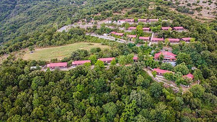
 Ano Doliana is a mountainous village built out of stone in the municipality of North Kynouria, eastern Arcadia, Greece. It extends at an altitude of 950 to 1,050 m, built amphitheatrically on the northern slopes of Mount Parnon. It is a protected traditional settlement.
It used to be the main residence of the settlers, but nowadays only a handful of them stay throughout the year, as most use it as their summer residence and instead overwinter in Kato Doliana because of the milder climate. In the 2010s, it has emerged as a relatively popular tourist destination, with a significant number of visitors, especially during the winter season weekends.
Τhe European long distance path E4 passes right through Ano Doliana, making it a hiking destination.
Get in
By car
From Athens, follow the European route E65 to Tripoli. Turn right on the exit to Tegea and Sparta. Drive 3.5 km on the old Tripoli-Sparta national road, towards Sparta. After 3.5 km, follow the sign to Doliana, by making a left turn. After 7.5 km, follow the sign towards Ano Doliana on the right. Finally, after another 3 km, turn right following the sign towards Doliana. The village is less than 5 km away from here.
Get around
A personal or rented vehicle is needed.
See
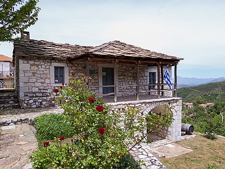
- Historical and Ethnographical Museum of Doliana (Nikitaras' Bullwark), 37.387955°, 22.498142°. We–Su, 09:30–14:30. Nikitaras and his klephts fortified this house during the Battle of Doliana. It's now a museum. Free entrance 2019/09/30
- Saint John's creek, 37.385101°, 22.506330°. Small waterfall. 2019/09/30
- Saint John's chapel, 37.388423°, 22.505754°. Here, Nikitaras and his klephts spent the night before the Battle of Doliana. 2019/09/30
- Bust of Nikitaras, 37.387114°, 22.498206°. 2019/09/30
- Tsakonas ravine, 37.387525°, 22.498278°. Main theatre of the Battle of Doliana, which took place in 1821, during the Greek War of Independence. 2019/09/30
- Old school, 37.386629°, 22.495747°. The oldest school of the village, built on 1853, declared a listed building since 1995. 2022/02/10
- Small marble theatre, 37.384088°, 22.494070°. 2019/09/30
- Ancient marble quarry, 37.392194°, 22.494902°. This is where the famous "marble of Doliana" is mined since antiquity. 2020/05/11
- Church of Virgin Mary, 37.386443°, 22.498261°. Main church of the village. 2019/09/30
- Church of Saint George, 37.388279°, 22.499491°. The oldest church of the village. 2019/09/30
- Church of Saint Elias, 37.379830°, 22.492780°. Little chapel situated at an altitude of 1.280 meters. 2020/05/11
- Church of Saint Paraskevi, 37.391273°, 22.495796°. 2020/05/11
- Church of Virgin Mary of Kouvli (Panagia Kouvliotisa), 37.4140748°, 22.4931433°. 2021/04/25
- Lutsitsa traditional fountain, 37.385380°, 22.498650°. 2020/05/11
- Sopotos traditional fountain, 37.411528°, 22.494987°. 2020/05/11
- Tsirikos traditional fountain, 37.385324°, 22.495808°. 2020/05/11
- Kontis traditional fountain, 37.383882°, 22.501521°. 2020/05/11
- Kontinos traditional fountain, 37.389717°, 22.512089°. 2020/05/11
- Vemmos traditional fountain, 37.396839°, 22.523659°. Located at Dragouni settlement. 2020/05/11
Do


- Chestnut Feast, 37.386671°, 22.498170°. Organized in late October to early November, when chestnut harvesting is over. Visitors have the opportunity to enjoy chestnuts in many different food and pastry recipes, as well as liqueurs. 2019/10/01
- E4 European long distance path. This international trail formed by the European Mountaineering Association (EWV) crosses the settlement, making it an ideal hiking destination. 2019/10/17
- Parnon Trail. 200 km of continuous walking trail, within the administrative boundaries of the province of Kynuria, which begins at its northern tip from Kouvlis and Ano Doliana settlements and crosses Parnonas. The specialty of the route is the combination of mountain and sea, as it alternates from the forests of Parnon down to its edges, where you can also hike by the sea and get to know the protected area of the Moustos wetland. In the Southern part of the trail we reach the region of Tsakonia, where the endagered Tsakonian dialect is spoken until today. 2019/10/17
- Run Doliana, 37.386431°, 22.494200°. Since 2015, an annual mountain trail half marathon takes place here, usually between late May to mid-June, alongside a 5-km race for less experienced runners and a 1000-m race for children. It is an event that has been upgraded since 2017 and is under the auspices of SEGAS, Greece's governing body for amateur sports. 2019/10/21
- Tselepos Winery, 37.429362°, 22.489649°, +30 271 054 4440. Short tour to the vineyards around the Kouvlis settlement and the chapel, followed by a walk to the old water mill, ending up in the winery, in order to be guided through the various wine-making areas, the wine aging vaults and the bottling installations. Your last stop is the wine tasting hall, where you can sample the locally produced Moschofilero wine, plus other labels of the winery. Open to visitors daily by appointment. 2019/10/15
- 5ΕΝΤΕ, 37.386009°, 22.498741°, +30 697 258 2918, info@5ente.com. Social cooperative company that organizes tourist, natural, sport, educational and artistic activities in the settlement. Among other things: hiking, biking, archery, paintball, "survival" games, art seminars, team building programs. 2019/10/25
Buy
- Melaki Dolianon, 37.419948°, 22.495321°, +30 693 40 16 646, +30 697 57 80 746, melakidolianwn@gmail.com. Traditional honey products in Kouvlis settlement. 2019/10/13
- Tselepos winery, 37.429362°, 22.489649°, +30 271 054 4440. Wine products from the vineyards in the surrounding area, in Kouvli settlement. Moschofilero is the main variety. 2021/08/13
Eat
- O Tholos, 37.386330°, 22.498624°, +30 271 022 7635. Tavern. 2019/08/25
- To Dragouni, 37.396961°, 22.524009°, +30 271 023 8570. Traditional tavern. 2019/10/01
- Platanos, 37.386537°, 22.498554°, +30 271 024 3178. Traditional tavern. 2019/08/25
- Dasiko Horio, 37.384583°, 22.495300°, +30 697 897 1575. At the chalet of the environmental settlement that has been built by the local forestry authority. 2019/08/25
- To Hani tou Koskina (Koskina's Inn), 37.394982°, 22.527082°, +30 271 022 2487. Tavern-grill. Also sells homemade cheese products and wine. 2019/10/01
Drink
- Onirologio, 37.386072°, 22.498700°, +30 271 024 1749. Art café. 2019/08/25
- I Kira Vouli, 37.386664°, 22.498483°, +30 697 701 8255. Traditional café. 2019/08/25
- To Hani tou Kouvli (Kouvlis' Inn), 37.414477°, 22.496047°. Traditional coffee shop under two large plane trees. It served as an inn for passersby back in the days when donkeys where used as the main transportation means. 2020/11/10
Sleep
- Erasmion, 37.386358°, 22.497362°, +30 271 023 4073, +30 6972 706 580, info@erasmion.gr. Traditional guesthouse. 2019/09/25
- 1821 En Dolianis Boutique Hotel, 37.386335°, 22.495455°, +30 271 022 3357, +30 210 985 3138, info@1821boutiquehotel.gr. Boutique hotel at the preserved, traditional building of the old school of the settlement. 2019/09/25
- Dasiko Horio, 37.384130°, 22.495479°, +30 697 897 1575. Artificial environmental settlement consisting of log houses, built by the local forestry authority, intended to facilitate short-term visitor stay in relative comfort close to the forest. Located at an altitude of . A big central chalet with unhindered view of the surrounding region is included. 2019/08/25
- O Tholos, 37.386330°, 22.498624°, +30 271 022 7635. Guesthouse on the main road of the settlement. 2019/08/25
- Hatzigiannis guesthouse, 37.386746°, 22.496918°, +30 6973 303 618. Traditional guesthouse. 2019/09/25
- "Andromache" traditional house, 37.387133°, 22.496907°, +30 6974 348 043, +30 6937 094 627. Traditional house operating as a lodge. 2020/10/18
Connect
Go next
Ano Doliana
Postal code:220 13Date Time:Please wait...Timezone:Europe/AthensPopulation:90Coordinates:37.39, 22.50
Arcadia Regional Unit
2nd-order administrative division
Peloponnese
Primary administrative division