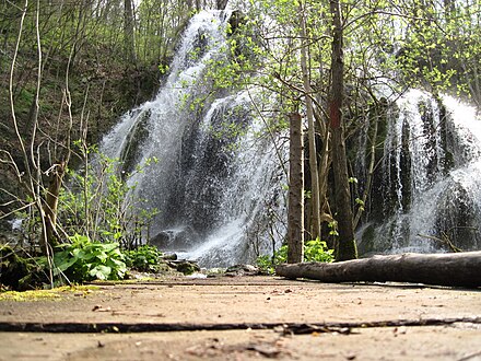
Beech forests of Europe - transnational UNESCO world heritage site
The Ancient and Primeval Beech Forests of the Carpathians and Other Regions of Europe is a world heritage site. First listed in 2007 and only including forests in Slovakia and Ukraine, it has been expanded in 2011 and 2017 and on both occasions its name was changed to reflect the extent of the site. As of 2017 it's made up of 78 forests in 12 countries around Central, Southern and Eastern Europe.
Trees can live to a hundred years old in these forests, providing an important habitat for organisms such as mushrooms, moss, lichen, insects, rare birds (e.g. capercaillie and black grouse) and mammals (e.g. bats, brown bear, wolf and lynx).
Understand
From being confined to mountain ranges, the European Beech (Fagus sylvatica) has, thanks to its adaptability, spread across most of the continent since the end of the last Ice Age. Beech forests are much darker than for instance the boreal forests found further north; the dense trees prevent sunlight from reaching the ground and this also means less ground vegetation. Perhaps the signature forest of Central and Southeastern Europe, 92,023.24 ha of forests (not including buffer zones) make up this natural world heritage site.
Beech wood is valued for its strength and nearly white colour. Many beech forests have been cleared, or are used for industrial forestry.
Sites
Albania
-
Lumi i gashit, 42.481389°, 20.057222°. 2017-12-27
-
Rrajca, 41.203056°, 20.500556°. 2017-12-27
Austria
-
Dürrenstei, 47.770000°, 15.047500°. 2017-12-27
-
Kalkalpen - Hintergebirg, 47.749444°, 14.482222°. 2017-12-27
-
Kalkalpen - Bodinggraben, 47.787222°, 14.353333°. 2017-12-27
-
Kalkalpen - Urlach, 47.804167°, 14.239444°. 2017-12-27
-
Kalkalpen – Wilder Graben, 47.833333°, 14.433611°. 2017-12-27
Belgium
-
Sonian Forest – Forest Reserve “Joseph Zwaenepoel”, 50.756389°, 4.416667°. 2017-12-27
-
Sonian Forest – Grippensdelle A, 50.781667°, 4.426667°. 2017-12-27
-
Sonian Forest - Grippensdelle B, 50.783611°, 4.432500°. 2017-12-27
-
Sonian Forest – Réserve forestière du Ticton A, 50.734167°, 4.436944°. 2017-12-27
-
Sonian Forest – Réserve forestière du Ticton B, 50.726944°, 4.430833°. 2017-12-27
Bulgaria
-
Central Balkan – Boatin Reserve, 42.802778°, 24.269167°. 2017-12-27
-
Central Balkan - Tsarichina Reserve, 42.775556°, 24.405000°. 2017-12-27
-
Central Balkan – Kozya stena Reserve, 42.796389°, 24.524722°. 2017-12-27
-
Central Balkan – Steneto Reserve, 42.745278°, 24.707222°. 2017-12-27
-
Central Balkan – Stara reka Reserve, 42.703056°, 24.818889°. 2017-12-27
-
Central Balkan - Dzhendema Reserve, 42.695556°, 24.973056°. 2017-12-27
-
Central Balkan – Severen Dzhendem Reserve, 42.745556°, 24.934722°. 2017-12-27
-
Central Balkan – Peeshti skali Reserve, 42.765000°, 25.074722°. 2017-12-27
-
Central Balkan – Sokolna Reserve, 42.697778°, 25.138333°. 2017-12-27
Croatia
-
Hajdučki i Rožanski kukovi, 44.766389°, 15.010833°. 2017-12-27
-
Paklenica National Park - Suva draga-Klimenta, 44.340556°, 15.500278°. 2017-12-27
-
Paklenica National Park - Oglavinovac-Javornik, 44.384444°, 15.449722°. 2017-12-27
Germany

-
Jasmund, 54.548056°, 13.645278°. 2017-12-27
-
Serrahn, 53.340000°, 13.197778°. 2017-12-27
-
Grumsin, 52.986389°, 13.895556°. 2017-12-27
-
Hainich, 51.078611°, 10.435556°. 2017-12-27
-
Kellerwald, 51.145278°, 8.973611°. 2017-12-27
Italy
-
Abruzzo, Lazio & Molise - Valle Cervara, 41.832222°, 13.728611°. 2017-12-27
-
Abruzzo, Lazio & Molise - Selva Moricento, 41.846944°, 13.705556°. 2017-12-27
-
Abruzzo, Lazio & Molise - Coppo del Morto, 41.860278°, 13.846667°. 2017-12-27
-
Abruzzo, Lazio & Molise - Coppo del Principe, 41.787500°, 13.744167°. 2017-12-27
-
Abruzzo, Lazio & Molise - Val Fondillo, 41.754167°, 13.885833°. 2017-12-27
-
Cozzo Ferriero, 39.905833°, 16.101111°. 2017-12-27
-
Foresta Umbra, 41.807500°, 15.977778°. 2017-12-27
-
Monte Cimino, 42.408611°, 12.203056°. 2017-12-27
-
Monte Raschio, 42.173611°, 12.161111°. 2017-12-27
-
Sasso Fratino, 43.844444°, 11.803056°. 2017-12-27
Romania

-
Cheile Nerei-Beușnița, 44.905278°, 21.811111°. 2017-12-27
-
Codrul secular Șinca, 45.666667°, 25.170556°. 2017-12-27
-
Codrul Secular Slătioara, 47.443333°, 25.627500°. 2017-12-27
-
Cozia - Masivul Cozia, 45.331667°, 24.325556°. 2017-12-27
-
Cozia – Lotrisor, 45.295278°, 24.259167°. 2017-12-27
-
Domogled - Valea Cernei - Domogled-Coronini- Bedina, 44.941944°, 22.468611°. 2017-12-27
-
Domogled – Valea Cernei- Iauna Craiovei, 45.108611°, 22.578056°. 2017-12-27
-
Domogled - Valea Cernei- Ciucevele Cernei, 45.244444°, 22.823056°. 2017-12-27
-
Groșii Țibleșului – Izvorul Șurii, 47.549722°, 24.185833°. 2017-12-27
-
Groșii Țibleșului - Preluci, 47.534722°, 24.220278°. 2017-12-27
-
Izvoarele Nerei, 45.122500°, 22.066389°. 2017-12-27
-
Strimbu Băiuț, 47.625833°, 24.073056°. 2017-12-27
Slovakia

-
Havešová Primeval Forest, 49.009722°, 22.338889°. 2017-12-27
-
Rožok, 48.975000°, 22.466667°. 2017-12-27
-
Stužnica – Bukovské Vrchy, 49.086111°, 22.536111°. 2017-12-27
-
Vihorlat, 48.929167°, 22.189722°. 2017-12-27
Slovenia
-
Krokar, 45.541944°, 14.768889°. 2017-12-27
-
Snežnik-Ždrocle, 45.584722°, 14.455278°. 2017-12-27
Spain
-
Hayedos de Ayllon - Tejera Negra, 41.234167°, -3.388611°. 2017-12-27
-
Hayedos de Ayllon - Montejo, 41.112222°, -3.499444°. 2017-12-27
-
Hayedos de Navarra – Lizardoia, 43.006389°, -1.112778°. 2017-12-27
-
Hayedos de Navarra - Aztaparreta, 42.910833°, -0.816111°. 2017-12-27
-
Hayedos de Picos de Europa - Cuesta Fria, 43.172500°, -4.987778°. 2017-12-27
-
Hayedos de Picos de Europa - Canal de Asotin, 43.171111°, -4.889167°. 2017-12-27
Ukraine

-
Chornohora, 48.140278°, 24.393056°. 2017-12-27
-
Kuziy-Trybushany, 47.939167°, 24.140556°. 2017-12-27
-
Maramarosh, 47.936667°, 24.326389°. 2017-12-27
-
Stuzhytsia – Uzhok, 49.070556°, 22.050278°. 2017-12-27
-
Svydovets, 48.189167°, 24.226944°. 2017-12-27
-
Uholka – Shyrikyi Luh, 48.306111°, 23.696111°. 2017-12-27
-
Gorgany, 48.471944°, 24.299444°. 2017-12-27
-
Roztochya, 49.962222°, 23.649444°. 2017-12-27
-
Satanivska Dacha, 49.173889°, 26.248889°. 2017-12-27
-
Synevyr – Darvaika, 48.487222°, 23.748889°. 2017-12-27
-
Synevyr – Kvasovets, 48.385000°, 23.712778°. 2017-12-27
-
Synevyr – Strymba, 48.453056°, 23.796667°. 2017-12-27
-
Synevyr – Vilshany, 48.355556°, 23.660000°. 2017-12-27
-
Zacharovanyi Krai - Irshavka, 48.452500°, 23.089722°. 2017-12-27
-
Zacharovanyi Krai - Velykyi Dil, 48.422500°, 23.161667°. 2017-12-27
See also
Ancient and Primeval Beech Forests of the Carpathians and Other Regions of Europe
Timezone:MultipleCoordinates:49.00, 15.00
