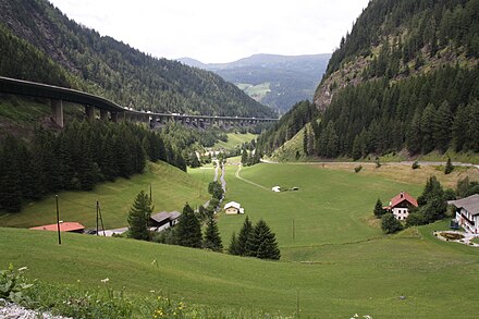
Brenner Pass - mountain pass at the international border between Austria and Italy
 The Brenner Pass is a pass through the Alps at the Austria-Italian border, at 1,370 metres.
The pass has been one of the most important passages through the Alps since ancient times. Today it is traversed by highway E45 and a railway between Innsbruck and Bolzano. Construction is underway on a 55-km-long base tunnel to flatten and shorten the railway. As of Oct 2019, it is expected to open in 2028.
In summer, the Brenner Pass is a gratifying route for hiking and cycling.
Understand
At a saddle height of "just" in altitude, it was one of the lowest Alpine crossings before tunnels were built.
The Brenner is one of the most important and frequently congested freight and passenger routes across the Alps and Austria, Italy and the European Union are working on improving the railway connection by building a massive base tunnel, rivalling that dug under the Swiss Gotthard massive.
History
The Brenner has been one of the major alpine crossings for centuries. The Cimbri set out to attack the Roman Empire when they crossed the pass in the second century BCE and later emperor Septimus Severus had a Roman road built that was called Via Raetia and was in use until the early modern era. For a long time, crossing the Brenner was arduous and dangerous, with barely existing roads often subject to avalanches, flooding and other natural hazards. Still, it was one of the most used Alpine crossings and used by such illustrious figures as Martin Luther or Johann Wolfgang von Goethe on their trips to Italy.
In 1867, the Brenner Railway opened; it was one of the first railways crossing the Alps. Following World War I, the border between Austria and Italy came to lie on the Brenner pass. The Brenner Autobahn was built in the 1950s and 1960s and has since been one of the most important crossings from Central Europe towards Italy and the scourge of numerous German holiday-makers who sat in congestion during the summer holidays.
Get in
By car
If you arrive by car, you'll have to get a Vignette (locally called "Pickerl" by some) for the Austrian highways. The only way to avoid this is to use no highways in Austria whatsoever, which is usually not worth it and sometimes impossible as local roads are closed to all non-local traffic during busy times. In Italy, highways have a distance-based toll, with the Brenner Highway no exception to this rule. The Austrian Brenner Autobahn is a "Sondermautstrecke" meaning that in theory you don't need a Vignette to drive on it, but you do need to pay the toll for that specific road. In practice, however, you'll have to use other Austrian highways to get onto this road in the first place.
By train
Innsbruck and Verona are well connected to the railway networks of their respective countries. Innsbruck also has frequent service from Germany, particularly Munich.
Cities and towns
- Innsbruck — a small Austrian city popular as a base for skiing, hiking and mountain-climbing
- Gries am Brenner — a base for skiing and summer tourism, with some historic churches
- Brenner — a town of 2,000 people with an outlet shopping centre (supermarkets and stores), fruit stores, restaurants, cafés, hotels and a gas station
- Sterzing — or Vipiteno, is a medieval town of 7,000 people
- Bolzano — an Italian city known for its characteristic Christmas market
Go
By car
- Brenner Autobahn. The joint Austrian-Italian motorway, designated as E45, A22 (Italy) and A13 (Austria) is a toll road and the only practicable way to cross the pass by car. It is notorious for congestion, particularly during the summer holiday season, when numerous Germans travel to Bella Italia. The Italian side has a website for the A22. €9.50 toll on the Austrian side, €15.60 on the Italian side 2020-01-22
- Europe Bridge (Europa Brücke), 47.202222°, 11.401944°. At the time of its construction, this was Europe's highest bridge. It is still an important part of the Brenner Highway, carrying the motorized traffic out of Innsbruck
- Brennerstraße (B182), 47.006463°, 11.505885°. The old and until the construction of the Brenner Highway only road across the pass it partially follows the old Via Raetia. The main advantage is that you do not have to pay a toll, but what you might save in tolls is more than made up for in lack of speed and higher fuel consumption. The views are nicer and the curvier road is more of a challenge for drivers, though
On foot
By bike
The pass is the easiest way to cross the Alps and often used by long distance or touring cyclist. The very easy gradient and low elevation make it suitable for families, cyclists on reclining or disability bikes, older, less fit or heavily laden cyclists. It's a unique opportunity to enjoy Alpine views without the demanding physical effort of some of the higher passes. Due to the low elevation it is general open throughout the year, in winter it is sometimes the only option to pass the alps by bike.
By train
Until the construction of the new Brenner Base Tunnel, all trains — local and international — take the old Brenner Railway from Innsbruck via Franzensfeste/Fortezza and Bozen/Bolzano to Verona. Tickets can be bought through both ÖBB and Trenitalia. Direct EuroCities take some three and a half hours from Verona to Innsbruck.
Related: E45 through Europe
Brenner Pass
Date Time:Please wait...Timezone:Europe/ViennaCoordinates:47.01, 11.51