Great Northern Peninsula - northernmost landform of the island of Newfoundland in Canada
 The Viking Peninsula or Great Northern Peninsula is a large rural area in western Newfoundland. Located north of Gros Morne National Park, it extends to St. Anthony (population 2400) as the northernmost town on the island of Newfoundland. L'Anse aux Meadows National Historic Site, a former Viking settlement at the northern tip of the peninsula, is one of the world's first UNESCO World Heritage Sites.
Understand
The Northern Peninsula is sparsely populated (about 25,000 people along 300 km of western coastline); weather conditions can be harsh, especially in winter, due to rugged terrain and direct exposure to westerly prevailing winds across the open Gulf of St. Lawrence. The population is declining. There are few tiny fishing villages and many wide open spaces.
Pack ice jams the Strait of Belle Isle in spring and early summer as icebergs further north break up during the spring thaw and are carried by ocean currents. One may encounter summer conditions ashore and winter conditions on the ice-filled water, or even be unable to get out of the harbour due to ice jams. Polar bears occasionally arrive on the Northern Peninsula from Labrador on the ice; animals or their tracks should be reported to Pistolet Bay Provincial Park staff so bears may be live-trapped and returned to Labrador.
Communities
- Hawke's Bay
- Main Brook
- Plum Point
- Port au Choix
- Port Saunders
- Quirpon Island
- Raleigh
- St. Anthony
- St. Barbe
Other destinations
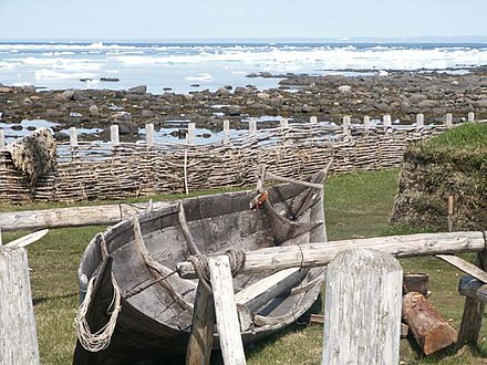
- L'Anse aux Meadows National Historic Site, Route 436 (north of St. Anthony), 51.595267°, -55.531222°, +1 709 623-2608 (May-Oct), +1 709 458-2417 (off-season), viking.lam@pc.gc.ca. 9AM-5PM daily, early June-Thanksgiving, 9AM-6PM summer. The site of the first established transoceanic contact between Europeans and Indigenous peoples of North America at around 1000 CE. It contains reconstructions of three Norse buildings, hiking trails, Viking guides in period costume, visitor centre and picnic area. The original archaeological excavations are understated as simple depressions in the ground and small grassy elevations. $12
- Port au Choix National Historic Site, Point Riche Road, Port au Choix, 50.6973757°, -57.3825625°, +1 709 861-3522. 9AM-5PM, mid-June to early September. An archaeological site about Indigenous peoples with a visitor centre. The centre guides through a history of the variety of groups that occupied the area from the Dorset Paleo-Eskimos to the Beothuk. Caribou can be seen wandering around the site and whales can also be occasionally seen off the coast.
- Burnt Cape Ecological Reserve, Burnt Cape, 1 km northwest of Raleigh, 51.561539°, -55.75353°. Over 30 species of rare plant life. Call ahead to book an excellent guided tour. Free year-round
- Pistolet Bay Provincial Park, Raleigh, 51.5400086°, -55.6793438°, +1 709 454-7570. Unsupervised beach, picnic area, fishing, canoeing, thirty camp sites ($15/night) with partial services (showers, toilets).
- Table Point Ecological Reserve, 14 km northeast of Daniel's Harbour on Route 430, 50.3595345°, -57.5380789°, +1 709 454-7570. Limestone cliffs and beach with many fossils from the Ordovician period. Accessible only by foot. Free
- The Arches Provincial Park, 50.113611°, -57.663056°. Provincial park named after the characteristic rock arches by the shoreline. 2020-05-23
Get in
By car
- From the Trans-Canada Highway, exit at Deer Lake and follow Highway 430 northward through Gros Morne.
By boat
- Newfoundland and Labrador Marine Services. Operates ferries connecting communities in Newfoundland and Labrador. 2022-05-18 Operates a vehicle and passenger ferry enabling travel between Newfoundland and Labrador. During most of the year this ferry operates between St Barbe and Blanc-Sablon, Quebec with a crossing time of 1.75 hours and operating 1-3 sailings daily. For portions of the winter, the ferry instead travels between Corner Brook and Blanc-Sablon with a crossing time of 12 hours.
By bus
From Labrador, board the ferry at Blanc-Sablon. The crossing to St. Barbe is 1¾ hrs, weather permitting, $25 for car and driver.
- Norpen Bus Service, +1-709-457-7110, norpenbus2022@gmail.com. This company runs a shuttle from Corner Brook and Deer Lake to St. Anthony Airport including a stop in St. Barbe. Operates one day per week. 2018-06-11
By plane
- St. Anthony Airport (IATA: YAY), 51.391944°, -56.083056°. This small airport in St. Anthony has scheduled service from St. John's and onward to Labrador and northern Quebec. Additional flights are available in Deer Lake 2018-06-11
- Provincial Airlines. Scheduled passenger, cargo and charter flights.
Get around
The only major local road is the Viking Trail, Newfoundland Highway 430, which follows the western coastline. Driving is the most accessible way to explore the area. Roads off the main highway may not be paved with poor conditions (e.g. large potholes) due to the weather. A 4WD vehicle and/or SUV is recommended if planning on driving much off the main roads. Caution and experience driving in winter weather is also recommended if planning on visiting during the non-summer season as the area is known for treacherous weather conditions.
See
- Cow Head Lighthouse, Cow Head, Newfoundland (across the thin strip of land which connects the old summer island and the mainland 'winter town.' You will see signs that point you to the lighthouse trail). A 10-minute hike with some stairs will bring you to the renovated lighthouse. This is very cool as it is open and you can climb up into the old lantern room and get a beautiful view of the Gulf of St. Lawrence. Free
- Grenfell House Museum, 227 West St, St. Anthony, 51.3667°, -55.5833°, +1 709-454-4010. Summer Daily 9AM-5PM, Winter M-F 8:30AM-4:30PM. A stately home that was the former residence of Sir Wilfred Grenfell, the founder of medical services in Western Newfoundland and Labrador. Adults $10 2020-05-23
- Grenfell Interpretation Centre, 4 Maravel Road, St Anthony, 51.363283°, -55.585031°, +1 709-454-4010. Summer Daily 9AM-5PM, Winter M-F 8:30AM-4:30PM. Museum that takes you through the life and work of Sir Wilfred Grenfell and the Grenfell Mission. Exhibits showcase historical medical equipment and the rugged conditions of providing medical care in Newfoundland and Labrador during the turn of the 20th century. Adults $10 2020-05-23
- Flower's Cove Thrombolites, Flower's Cove (1 hr drive south of St Anthony on Highway 430), 51.299283°, -56.728442°. Circular fossil-like structures of algal colonies millions of years old arrayed along the coast line of this small town. Free 2020-05-23
Do
- Drive along the Viking Trail, Highway 430. Scenic road that extends from Deer Lake through Gros Morne National Park to the northern tip at St. Anthony. The southern parts takes you through the park passing by many viewpoints that would be amiss to not stop at. The northern parts of the trail takes you along the sea coast through small windswept fishing villages. During the summer, icebergs can be seen on the sea throughout the drive.
- Iceberg Festival, St Anthony. Beginning yearly on the first Friday of June for around 10 days, the festival is a celebration of the start of iceberg watching season. Based around the town of St Anthony, there are usually a variety of events involving music and food.
- Scenic Pursuit, 51 Main St, Bide Arm, +1 709 457-2706. Seasonal, M-Sa 9AM-8PM. Boat tours from Canada Bay, charters, iceberg and whale watching.
Buy
- Dark Tickle Company, 75 Main St, St. Lunaire - Griquet, 51.5049692°, -55.4816304°, +1 709 623-2354. Manufactures jams, sauces, vinegars, teas, drinks and chocolates using wild berries from Newfoundland and Labrador. Books, clothing, souvenirs.
Eat
- The Daily Catch, 112 Main St, St. Lunaire-Griquet, 51.5046321°, -55.471637°, +1 709 623-2295, heddersons@nf.aibn.com. Seafood, pork, chicken. $6-12
- The Norseman Restaurant, L'Anse aux Meadows (end of Route 436, turn right at harbourfront), 51.6006°, -55.5274°, +1 709 754-3105 (phone), +1 709-623-2126 (mobile text), ginanoordhof@gmail.com. Daily noon-9PM. Focusing on fresh, healthy, local and gourmet. In 22 years they have never served a french fry. 2015-10-13
Drink
- Skipper Hot's Lounge, Straitsview, St. Lunaire-Griquet, 51.5813587°, -55.4947736°, +1 709-623-2241. noon-midnight daily (June-Sept), 2PM-midnight weekends off-season. Bar and lounge, take-out fried foods and sandwiches, live music, billiards and darts.
Sleep
L'Anse aux Meadows
- Marilyn's Hospitality Home, L'Anse aux Meadows, 51.5203455°, -55.4615428°, +1 709 623-2811. B&B with full breakfast and fresh-made bread, one block from waterfront.
- Snorri Cabins, Route 436, Straitsview, 51.5811837°, -55.4934358°, +1 709 623-2241. Open year-round.
- Southwest Pond Cabins, Route 436, St. Lunaire-Griquet, 51.5297915°, -55.4844185°, +1 709 623-2140. Seasonal (May-Oct).
- Valhalla Lodge, Gunners Cove Harbour Front, L'Anse aux Meadows, 51.5417516°, -55.475185°, +1 709 754-3105. Norseman Restaurant, Gaia Art Gallery and Valhalla B&B.
Hawke's Bay
- Torrent River Inn, Hawke's Bay, 50.6099758°, -57.169674°, +1 709 248-5225.
Main Brook
- Tuckamore Lodge, 51.1617587°, -56.0018288°, +1 709 865-6361, info@tuckamorelodge.com. Hunting, fishing and adventure tourism lodge.
Plum Point
- Plum Point Motel and Restaurant, Plum Point, 51.0824989°, -56.8783896°, +1 709 247-2533, info@plumpointmotel.com. 40 rooms, restaurant, 18 housekeeping units.
Port au Choix
- Sea Echo Motel & Restaurant, Port au Choix, 50.7039756°, -57.354334°, +1 709 861-3777, info@seaechomotel.ca. 30 rooms, 3 cabins and 10 campsites, Point Riche Restaurant (and Greco Pizza), Sea Gull Lounge, souvenir shop, banquet/conference services.
Raleigh
- Burnt Cape Cabins, Raleigh, 51.5571693°, -55.7307615°, +1 709 452-3521, bdz@nf.sympatico.ca. Adjacent to Burnt Cape Ecological Reserve, dining, groceries, fuel. Cabins with Internet and en suite bath.
St. Anthony
- Grenfell Heritage Hotel & Suites, 1 McChada Drive, St. Anthony, 51.3638929°, -55.5874901°, +1 709 454-8395, info@grenfellheritagehotel.ca. Conference facility, wi-fi, continental breakfast, smoke-free, no pets.
- Haven Inn, 14 Goose Cove Road, St. Anthony, 51.3723956°, -55.6021673°, +1 709 454-9100, info@haveninn.ca. Cartier's Galley Restaurant with view of St. Anthony harbour, pet-friendly hotel, wi-fi.
- Snuggle Inn Cottage Suites, 7 Gulley Bank Rd, St. Anthony, 51.3591601°, -55.5780833°, +1 709 454-2408, info@snuggleinn.ca.
St. Barbe
- Dockside Motel, St. Barbe, 51.2017678°, -56.7770267°, +1 709 877-2444. At Blanc-Sablon/Labrador ferry dock.
Connect
Go next
Great Northern Peninsula
Date Time:Please wait...Timezone:America/St_JohnsCoordinates:50.46, -56.77
Newfoundland and Labrador
Primary administrative division