Jajce - town in Bosnia and Herzegovina
 Jajce (dead link: January 2023) is a small 14th-century walled town in nortwestern Bosnia and Herzegovina, well known in former Yugoslavia for its waterfalls, fortress and old town.
Understand
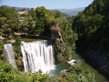
Jajce is situated in a mountainous valley at the confluence of the Pliva and Vrbas rivers. The scenic waterfall is one of the town's main landmarks. The town was an important place in previous centuries, and 24 national monuments bear witness to its vibrant history.
Get in
- Autobusni kolodvor Jajce (Bus Station), 44.33712°, 17.26821°, +387 30658047. Buses on the Banja Luka-Sarajevo Line stop in Jajce. The bus to/from Travnik costs 17.20 KM and takes 1½ h. 2022-10-01
Jajce is located at the crossroads between Banja Luka (North), Mrkonjic Grad (Northwest) or Donji Vakuf (South).
Get around
The easiest way to get around Jajce is by foot. All main sites are located within a short distance of each other.
See
Many of the sights inside Jajce are not constantly manned, so if it is not a busy day you may need to hang around outside for a few mins or follow a note to find the keyholder.
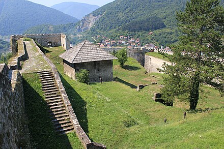
- Fortress, 44.34084°, 17.26910°. Dominating the town, this hilltop fortress offers great views over the town and nearby hills. Inside it is very sparse with almost no information and little more than the walls to walk around, however you will likely have the place to yourself. Pleasant views over the town but debatable if these alone warrant the cost and the steep walk up. 5 KM
- Pliva Waterfall, 44.33754°, 17.27065°. This is the waterfall where the Pliva River meets the Vrbas River. Scenic view points can be accessed on both sides of the waterfall (the southern offering the better view), and on the far bank requiring more effort to get to but a great view back across the town. Viewing the waterfall from above is free, but less spectacular. Expensive for what amounts to a 10 minutes stroll and a photo opportunity. 8 KM 2017-12-04
- Franciscan monastery, 44.3412°, 17.2738°. Monastery with many artworks and historical items, the latter including the skeleton of the last Bosnian king. 2019-09-05
- Underground church - Catacombs, 44.33953°, 17.26828°. A cluster of small rooms make up the catacombs. Very dim light combined with uneven ground mean caution is needed. The 5 minutes it takes to visit hardly warrants the entrance fee, although a guidebook sold at the ticket kiosk helps. 4 KM 2017-12-04
- Ethno museum, 44.3395°, 17.2695°. If you're interested in the town's history, you can get several books (including serious monographies) here. The exhibit itself is nothing spectacular. 4 KM 2019-09-05
Do

- 5 km up the Pliva from the town is the Pliva Lake, where you can go swimming or fishing, or go camping beside its little watermills. The "money shot" for a dedicated photographer is from across the other side of the river, which can capture the falls, city, and fortress in one shot.
Buy
- TROPIC Supermarket, Kulina Bana 1, 44.34033°, 17.26721°. M-S 07:00-21:00, Su 08:00-20:00. A large shop just outside the city walls provides all daily needs. 2017-12-04
Eat
A number of reasonably priced restaurants and cafes are in the town centre along H.V.Hrvatinića.
- Cevab Dzinica Dedo, 44.3383404°, 17.2712407°. A great and inexpensive gem hidden behind the tourist eyes. It has a great view and terrace over the river canyon. 2022-10-01
Drink
A series of bars/clubs are located just outside the south side of the city walls along H.V.Hrvatinića.
Sleep

Budget
- Jajce Youth Hostel, Stjepana Tomasevica 11, 44.34103°, 17.26253°, +387 63 262 168, jajceyh@gmail.com. A modern building about 5-10 minutes walk outside of the town centre. Ample free parking. Campsite available in summer. Dorm €8, Private from €15 2017-12-04
Connect
Go next
Banja Luka is about an hour and a half's drive up the Vrbas river through some fantastic gorges and rural scenery.
Jajce
opcina-jajce.baPostal code:70101Date Time:Please wait...Timezone:Europe/SarajevoCoordinates:44.34, 17.26
Federation of B&H
Primary administrative division