Khao Kho - district in Phetchabun province, Thailand
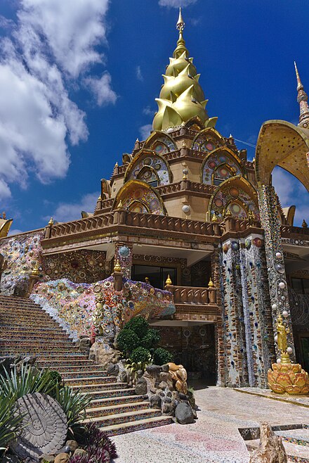
Khao Kho is a mountainous, sparsely-populated district of Phetchabun Province in Lower Northern Thailand. It is noted for its wooded mountain landscape as well as architecturally unusual Buddhist temples and meditation centre.
Understand
The district is named after the Khao Kho, a 1143 metre high peak of the western Phetchabun Mountain range. The district's most populous settlement is Khek Noi 📍, which is also home to Thailand's largest Hmong community. Most points of interest to tourists, including the Wat Phra That Pha Kaeo, are in Khaem Son 📍 (Camp Son) subdistrict. The district administration and several resorts are in the eponymous Khao Kho subdistrict 📍
Get in
The curvy highway No. 12 cuts across Khao Kho on its way from Phitsanulok (c. 100 km) to Lom Sak (c. 30 km) and Khon Kaen (c. 220 km). Buses of the Phitsanulok–Lom Sak–Khon Kaen line run through Khao Kho district, but most intercity buses do not stop here. However, there are local buses from Phitsanulok (normal bus station; 2 1/2 hours; 80 baht) or Lom Sak to Khaem Son.
Get around
See

- Wat Phra That Pha Son Kaeo (Wat Prathat Phasornkaew; วัดพระธาตุผาซ่อนแก้ว; formerly Wat Pha Son Kaeo), Tambon Khaem Son, Amphoe Khao Kho, Phetchabun 67280 (7 km north of highway no. 12. From where the bus stops you have to walk for 25 mins up a hill, or hitch a ride on the back of a pick up truck.), 16.78926°, 101.05085°. Buddhist place of worship and meditation, founded in 2004. Wat Phra That Pha Son Kaeo is completely covered in beautiful mosaic art, walls, floors and stairs are designed in a smooth, fluid way which is reminiscent of Antoni Gaudí. You can climb this temple quite a bit and have an amazing view on the surrounding hills. The Sitting Buddha Statue temple, which is just on the other side of the road, is actually five Buddhas sitting in front of each other and getting smaller.
- Khao Kho National Park, 16.619722°, 101.038056°. 2019-12-20
- Phra Borommathat Chedi Kanchanaphisek, Tambon Khao Kho, 16.64095°, 101.00081°. Buddhist temple
- Thale Mok viewpoint, Tambon Khao Kho, 16.62989°, 100.9954°. View of the "sea of fog".
- Khao Kho Memorial, Tambon Khao Kho (on road no. 2323), 16.61497°, 100.98571°.
- Weapon Museum, Tambon Khao Kho (on road no. 2323, 1.3 km south of Khao Kho Memorial), 16.60368°, 100.98346°.
Do
Buy
Eat
Drink
Sleep
Khaem Son (Camp Son) subdistrict (near Wat Phra That Pha Son Kaeo temple)
- The Imperial Phukaew Hill Resort, 99 Moo 14, Phitsanulok-Lomsak Rd, Camp Son, Khao Kho District, Phetchabun 67280, 16.78414°, 101.01002°, +66 56750056. 2019-12-20
- Kiri Pura Resort, 53 Mu 7 Tambon Khaem Son, Amphoe Khao Kho, Phetchabun 67280 (500 m from Wat Phra That Pha Son Kaeo), 16.78429°, 101.05127°, +66 064-978-6563. 2019-12-20
- Khokirin Resort, 201 Mu 7 Ban Thang Daeng, Tambon Khaem Son, Amphoe Khao Kho, Phetchabun 67280, 16.77924°, 101.04614°, +66 085 441 1919. 2019-12-20
Khao Kho subdistrict (near National Park)
- Khao Kho Talemok Resort, 53 Mu 3 Ban Simarak, Tambon Khao Kho, Amphoe Khao Kho, Phetchabun 67270, 16.62532°, 100.99375°. 2019-12-20
- Ban Ton Kho Resort & Restaurant, 292 Mu Thi 12 Ban Song Khum, Tambon Khao Kho, Amphoe Khao Kho, Phetchabun 67270, 16.64317°, 100.9912°. 2019-12-20
Connect
Go next
- Lom Sak, 30 km east
- Phetchabun, 60 km southeast
- Phitsanulok, 100 km west
- Phu Kradueng National Park, 170 km east (2:35)
Khao Kho
Postal code:6727067280Date Time:Please wait...Timezone:Asia/BangkokPopulation:39,721Coordinates:16.63, 101.00
Phetchabun
Primary administrative division