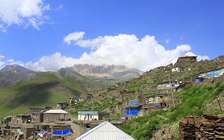
Khinalug (dead link: December 2020) the highest (2250 m above sea level), most remote and isolated village in Northeastern Azerbaijan and among the highest in the Caucasus.
Understand

 It has a population of about 2,000 people. Since its inclusion in Mark Elliott's guidebook, it is considered one of main attractions of Azerbaijan. The village inhabitants speak their own language, not spoken anywhere else.
Get in
It's 50 km from Quba, which can easily be accessed from Baku by bus (4 hr). The rest of the way requires hiring a car or a taxi.
By car
In 2006, the road was paved due to a visit from Azerbaijan's President. Now, a car can make the trip to Khinalig. Before paving an SUV was essential (but still recommended).
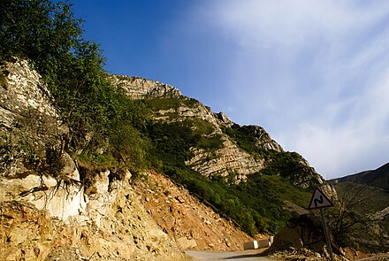
By Quba go straight on the main road from Baku, not crossing the river, after passing the roundabout look for signposts on Qəçrəş. The first 20 km is not that interesting, but it changes dramatically after entering the ravine. At km 41 from Quba there is a bridge, behind which you have to turn right, towards the village of Cek.
By taxi
Prices will be negotiable, but expect to pay around 40 manat from Quba. You may be quoted more, but haggling is acceptable.
By bus
No buses are available to this location.
Get around
Walk. There won't be many other options. It should not be a problem for a reasonably fit person though you might find yourself winded from the steep hills and high altitude. Khinalug is a very small settlement.
See
Surrounded by mountains and green valleys at summer, Khinalug offers fabulous natural scenery.
- The houses in Khinalug are a visual example of the distinctive village. The houses are built like a staircase - each roof is another's house front door terrace. Pay attention to the cubes of dried fertilizer, serving as fuel in the winter. A half-hour walk among households should give a good impression of it.
- Historical-Ethnographic Museum. A modest exhibition of vessels, weapons, medals and a "library". Usually you have to ask locals in order to find key-keeper – azeri: Açar var? 2008-08-06
- Good views over the village can be seen from the old upper road.
Do
 Khinalug boasts of some of the best hiking and camping in Azerbaijan. The surroundings of the village are wide open and include nearby caves with a waterfall. The water is actually filtering through the cliff rocks. More extensive hikes can be done by using a guide book or hiring a local guide. Horses can also be rented to carry gear and/or people.
Keep in mind that hiking is not considered a recreational activity for most Azerbaijani people, but Khinalugian people are more appreciative of the benefits of eco-tourism.
- Hiking. Khinalug is a great base to explore the surrounding mountains: Khinalig, Şahdağ, Heydər düzü, Tufan Dağ. You can also arrange a trek from here to the two village called Ləzə - one is located near the town of Qusar (2-3 days) and the other in the vicinity of Qabala (1 day).
Hiking to the nearby village of Qalayxudat is possible via the old road connecting the two villages. Some shepherd roads branch off from this route, making for a good loop hike up the side of the mountain. The area is near the Russian border, so border guards regularly patrol it and will very likely stop all hikers to check for permits. Speaking Russian is advisable, as they're able to call their commanding officer to get you permission to continue.
- __Khinalig__, [41.127764°, 48.108502°](https://www.google.com/maps?ll=41.127764,48.108502&q=41.127764,48.108502&hl=en&t=m&z=11).
- __Şahdağ__ (_King Mountain_), [41.2711°, 48.0116°](https://www.google.com/maps?ll=41.2711,48.0116&q=41.2711,48.0116&hl=en&t=m&z=11). Azerbaijan's highest mountain.
- __Heydər düzü__, [41.2401°, 48.1086°](https://www.google.com/maps?ll=41.2401,48.1086&q=41.2401,48.1086&hl=en&t=m&z=11).
- __Baltagaya__, [41.2332°, 48.0725°](https://www.google.com/maps?ll=41.2332,48.0725&q=41.2332,48.0725&hl=en&t=m&z=11). Cliff mountain pass at 3,200 m. From here, great views of the valleys on Khinalug and Laza sides. Also a vantage point for Şahdağ.
- Roundtrip Baku to Khinalug (Xinaliq), bakutaxi@gmail.com. Leave day 1, arrive and sleep in Khinaliq or village of your request. Return day 2 around mid day. Many opportunities to stop and take pictures. All additional gas burning excursions from route can be negotiated. Contact a taxi a few days in advance to schedule service. 130 manat for a driver from Baku to Khinaliq and back to Baku
- Horseback riding, +994 169 49076. 20 manat/day (2008)
Buy
Buy some local products, such as socks or a hat. When someone offers you a tea, do not refuse, but expect that after finishing, the hosts will offer something for sale.
- Shepherd's cap – Made from wool, these caps will keep your head toasty in the coldest conditions. The caps are very distinctive to this area. The caps come in several colours; from white to dark wool.
Eat
- Mutton –: Khinalug is a vegetarian's nightmare. The high altitude won't allow many vegetables to grow.
Drink
Sleep
There is an official guest house but a number of local families offer home-stay arrangements from 5 manat. Either way, there will always be an option due the hospitality of the local population.
- Zaur Lalayev, +994 518309720. Runs a guest house from his family home. His family will offer you warm home cooked meals and hot tea. Zaur's late father Badal was featured in Mark Elliot's guide book. Zaur now took over and runs hiking and horse excursions adventures. 15 manat per person would be appropriate, but Zaur likes his guests to only pay what they can.
- Agali Muradov, +994 506426303. Same guy who also offers tours from Quba.
- Rauf, +994 169 49076.
- Rustam Xinaliqli. Rustam and his family have a room they rent out to travelers with floor mattresses and warm blankets. Can also arrange transport to and from Quba. 20 manat per person per night rate, breakfast and dinner included. 2018-06-04
Connect
Spotty GSM connection exist in some parts of a town (at least Azercell provider works). No other internet options except for aforementioned GSM is available (2008).
Go next
-
Quba – Probably the place where you started from.
-
Qizil Gaya. 2015-08-06
-
Ateshgah (Atəşgah). A sacred, natural, eternal flame. 2015-08-06
-
Cloudcatcher Canyon. Scenic landscape between Quba and Khinalig. 2015-08-06