Lahemaa National Park - protected area in Estonia
Lahemaa National Park (Estonian: Lahemaa rahvuspark) is a national park in North Estonia. It was the first national park to be created in the now dissolved Soviet Union.
Understand
Lahemaa National Park is the largest national park in Estonia and about an hour east (50 km) of Tallinn. Given its size it is the largest park in Estonia and one of Europe's biggest national parks, with 1000 km<sup>2</sup>. Lahemaa, which roughly translates as "land of bays", adjoins the coast of the Gulf of Finland. The seaside consists of four peninsulas (Yuminda, Pyarispea, Kiasma and Vergi) and four bays (Kolga, Khara, Eru and Kiasma). Besides that, it is a place to find some nice forests, trails, bogs, swamps, wildlife, and 4 manors.
For more information see: http://loodus.keskkonnainfo.ee (dead link: January 2023) (search for Lahemaa rahvuspark).
History
The area was once used for properties of several rich German landowners. However, around the First World War, landowners were expelled, and the country houses were used for different purposes.
Landscape
Most of the park is occupied by coniferous forest and peat bogs. It is mostly flat, and on the coast there are sandy beaches. There are also very exotic landscapes, for example, wastelands, overgrown with juniper, karst fields, and swamps and bogs.
Flora and fauna
Some parts of the park are off-limit during the breeding season. It is not ensured that people hold on to it, so take responsibility and use your mind. Especially annoying can be the mosquitoes, which during cycling, are not much of a problem as long as you do not stand still.
The "speciality" of the Lahemaa National Park are the huge water reservoirs called bogs. They get their water supply from the rain. Their surface is often covered with a thick and soft Sphagnum moss, which absorbs water into its empty cells. The lack of oxygen and acidity in a bog is the reason why dead plants deposit as partially decayed vegetation matter, the peat. A water drainage through the peat works very slowly. During the process of growth of a bog, wet hollows are enriched with oxygen, decomposition is accelerating and bodies of water, called bog pools, form. The process takes several thousand years. The depth of bog pools is generally less than 2 m, but can reach a maximum depth of 3–4 m in Viru raba. The humin acids found in the peat give the brownish hue and acidity to the bog water. Due to its acidity, this environment is unfavourable for the growth of many organisms.
Climate
Fees and permits
There are no entry fees, all the trails are free to hike.
Get in
The park is large and has many interesting places to go to. Therefore, it is hard to give only one set of directions for getting there.
By bus
It is easy to reach the borders of the national park and especially the suggested hiking trails by bus, since it is along the major route from Tallinn to the east. Many buses, often hourly, leave from Tallinn (along Pärnu/Narva mnt) and stop at Loksa tee 📍, the exit for Loksa town at the highway. Price: €3.50.
Some buses should also go into the smaller villages inside and around Lahemaa national park, or connect from Loksa tee. They are however more sparse and might not go exactly where you want to.
All connections are available online, especially through Peatus.ee. See Estonia#Get around for more information.
By car
To see also the rest of Lahemaa National Park, besides the beautiful trails starting near the highway, it is more preferable to have a car.
Drive from Tallinn towards Narva via Peterburi road. About 50 km from Tallinn, there is a sign for Loksa (left), aka Loksa tee. You may want to turn there, as after a few hundred metres via this smaller road towards Loksa (direction north), the starting point to Viru raba will be on your right. Or you may want to drive to Loksa, further on to the seaside, or to the various other villages.
By train
If you intend to hike the trail through Kõnnu Suursoo, Aegviidu 📍 is the best starting or exit point for the trail, and along the main railway route towards east, for cities like Tapa, Rakvere, and Narva.
Many trains per day leave from/to Tallinn, see Elron.ee and Estonia#Get around.
Price from Tallinn to Aegviidu: €3.
By bicycle
It is also popular to take a bike tour through the park: 1–3 days, 35–65 km, with easy access from Tallinn. City Bike (bicycle rental and tours) organises daily tours and also offers self-guided packages to the park. But you can also rent a bicycle and do the tour an your own, if you have figured out all the sights. Check whether it is possible to take the bikes onto the bus at least until Loksa tee.
Get around
If you came here for hiking then by foot will be your preferred option.
To travel between the villages and from the highway, not so frequent buses can be used. See Estonia#Get around.
But for the latter, a car or bicycle might be your preferred choice.
See
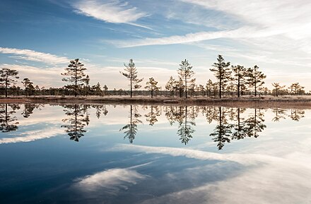
- Viru raba (Viru bog), 59.474461°, 25.662534°. One of the most suggested place to go there is Viru raba, which has a foot track and observation tower. You can start and finish in same location if you go to the tower and back (2 km) or take a round trip around the swamp (5 km), see trails under #Do. There are good maps and information tables at the track.<br/>The track over the swamp is made of wood; generally, no special foot wear is necessary. Sometimes there may be more water in the bog, and at those times, waterproof hiking boots are recommended.
- Kõnnu Suursoo, 59.4103°, 25.6991°. Not in Lahemaa National Park but at its border, and larger and more diverse than Viru raba. A huge bog with countless water pools and also a wooden plank trails over the swamp.
- St. Mary Church, Tallinna 54, Loksa (at the entrance of Loksa on the left side), 59.57526°, 25.72459°. A small cemetery church built in the middle of the 19th century. If you are lucky enough to get inside, pay attention to the huge and rather modernist picture of the Crucifix in the altar.
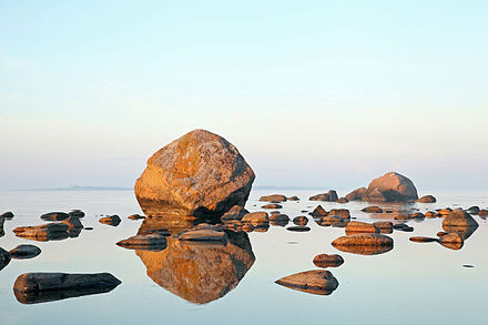
- Pähknemännik, 59.67437°, 25.69642°. The northernmost point/peninsula of mainland Estonia is a stony spit that stands out almost 1 km into the sea. It is about 4 km from Viinistu. Here you wade through the sand and rocks, along the way enjoying the panorama, stones, and pretty paginated birds. Take a stop at the Mähu boulders in Pärispea village. You can climb on it with a special rope, and from it explore the neighbourhood. Excellent panoramas and thickets of dog rose. There are sandy beaches, where you can swim in warm weather.
- Boulders, Laane tee 4, 59.61569°, 25.91237°. Boulders in Lahemaa are everywhere, but in Käsmu they are especially numerous and huge. Each large boulder has its own name, indicated on the park's maps placed here and there. One of the largest stones can be seen from the left side on the road to Käsmu, about 1 km before the village. Another interesting place is the northern tip of the peninsula, where the stones form a kind of bridge to the island about 500 m from the Shore of the Devils. You can get there by going to the very end of the road (there is a small parking lot) and further along the path through the forest. Here you will find the largest boulder, Kiasma, which is more than twenty meters in diameter.
Manors
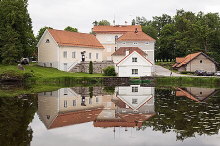
- Vihula Manor (Vihula mõis), 59.54677°, 26.18323°. Perhaps, this is one of the most interesting Estonian estates. It does not have a luxurious palace - on the contrary, both manor houses are small and rather modest. However, a huge complex of outbuildings has survived; barns, stables, a tea house, a laundry, a water mill and even a distillery. All of them from the 19th century and in perfect condition, performing different functions in this spa hotel on the manor. Adjoin a restaurant, a tavern, a cosy café next to the water mill, a swimming pool, a gym, etc. There is no museum. However, the appearance of the buildings, their picturesque pile and the pond with the hammered wooden bridges deserve attention. At the entrance from the west a restored windmill appears.
- Palmse Manor (Palmse mõis), Palmse küla, Vihula vald, Lääne-Viru maakond, 59.512796°, 25.956213°, +372 55599977, +372 3240070. 10:00-18:00 (museum). An 18th-century manor house and its park, and one of the most prominent and grand baroque manor buildings in Estonia. The manor and park where inhabited by a Baltic German family before they were ousted in 1913 like many other such families in Estonia. The manor house is still equipped with furniture from the beginning of the 20th century. It was the first fully restored manor in Estonia. €5 for park and manor house 2017-10-12
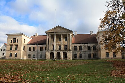
- Kolga Manor (Kolga mõis), 59.49192°, 25.61127°. Museum: 15 May–15 Sep 10:00–18:00, otherwise M-F 10:00–16:00. The manor is in the village of the same name, directly on the road. It has a rich history. Since the 13th century there was a fortress, which was destroyed in the Livonian War. Later, on the site of the fortress, a manor house was built. The central house of it was built in the 1820s in the style of classicism with a painfully familiar portico. Nowadays, the house is in a semi-abandoned, heavily dilapidated state. Part of the building occupies a shop with the promising name Mõisa Pood (manor shop), but actually it is a regular food store, filled with shelves and refrigerators. In addition to the central house, a well-restored farm buildings is of interest. It, probably, dates back to the 18th century with glimpses of European architecture. Nearby, the local lore museum can be found.
- Sagadi Manor (Sagadi mõis), Sagadi küla, Vihula vald, Lääne-Viru maakond (1.5 km to the east of the village with the same name), 59.53710°, 26.08455°, +372 6767888. Museum: May–Sept 10–18:00. There is a hotel and a pretty pathos restaurant. In the central building the museum of the manor can be found (interiors of the 19th century, and hunting room). There is also a forest museum (with an interesting exhibition about Estonian nature) and a cage; a wooden building for ordinary people, where they tell about the everyday life of the Estonian peasantry. From the end of the 17th century the manor belonged to Baltic Germans (von Fokov). The palace is made in the style of classicism; cornice is decorated with bowls, from a distance reminiscent of samovars. The rest of the buildings are typical for Estonian estates. The eye can overlook this point, the bright pink colour of the palace is slightly annoying, but otherwise pretty. One can walk around the park along the pond located behind the palace. Also, take a look into the apple garden to the left of the entrance, especially in September. Free. RMK Sagadi Forest Museum: €3 2017-10-12
Towns
- Käsmu 📍 – A small coastal village set in the park. It is a settlement on the peninsula of the same name, known as the "village of captains". From 1884 to 1931, there was a naval school here. Also, in the adjacent bay the ships used to be wintering. The local captains were particularly famous for their illegal trade with Finland – first by smuggling of salt, and in the 1920s, almost as now, of alcohol. Käsmu is probably the most visited place on the coast of Lahemaa National Park. Look at boulders and the sea, touch the history in the interesting naval museum, see the wooden lighthouse, or simply go out by boat. The village is built up by private houses-estates, which are somewhat similar to each other and painted in unusual way for Estonia, almost white colours with some kind of a shade.
- Võsu 📍 – A beach village in the park.
- Loksa 📍 – The largest and at the same time the probably most boring town in the park. Located on the western coast of the Peninsula peninsula, at the mouth of the Valgeijõgi River, offers views of the Hara Bay. It is built up with post-war dwelling and panel houses and has its own port.
Do
Hiking
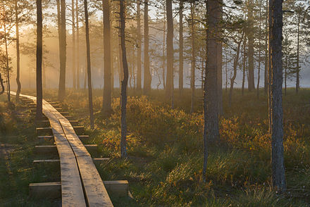 One of the most widely recommended places to go there is Viru raba, which has a 5-km foot roundtrack and observation tower. The following two trails cover this sight. The third one is longer, more diverse and includes a larger swamp than Viru raba, south of the highway. The projected walking times depend on whether you are just there for the hike, or also want to take your time for bird watching, longer breaks and such. All three allow for day tours from Tallinn, depending on your level of fitness. The tours partly correspond to sections of the "official" RMK matkatee (hiking path by the forest authority).
-
Viru raba (short) (<span style="color:#22CA54; font-weight: bold;">green</span>). Distance: 5.69 km, flat. Duration: 1.5–2 hr. Grade: Easy. Recommended: comfortable clothes and shoes for walking; waterproof hiking boots during or after rain. This is an easy hike and gives you the opportunity to see the bogs and swamp from the biggest wooden watchtower in Estonia. The first part of the track until the watchtower is even a wheelchair-accessible 1 m wide wooden path. After the watchtower wooden planks continue.<br/>First you walk through a pine forest, then go out onto a wide wooden floor leading through a wet but not yet melted soil with stunted pines. About 1 km from the parking lot you will find the observation tower, which you must climb. From the tower begins a dike that stretches along the most real marsh, winding among small lakes – on one of them even a bathhouse is built. The water is dark, but very clean – you can dip. From the tower it is about 1 km to the eastern edge of the swamp, and then you either need to return the same way, or go through the forest further west, bypassing the swamp from the north. There you will be walking on the swamp's magnificent mosses, quietly, calmly and somehow a little too lifeless.<br/>Download coordinates: GPX, KML.
-
Viru raba (long) (<span style="color:#615CF3; font-weight: bold;">blue</span>). Distance: 14.13 km, mostly flat. Duration: 3–5 hr. Grade: Medium. Recommended: comfortable clothes and waterproof hiking boots for walking, the latter especially during or after rain.<br/>This is an extension to the short Viru raba roundtrack for people excited with forests and nature walks. It presents more of the national park, besides just swamps and bogs, and dives deeper into this region.<br/>Download coordinates: GPX, KML.
-
Kõnnu Suursoo (<span style="color:#FFC41F; font-weight: bold;">orange</span>). Distance: 27.50 km. Total climb: 280 m. Total descent: 294 m. Duration: 6–8 hr. Grade: Medium. Recommended: waterproof cloths and hiking boots, sleeping mattress and bag. The trail across the swamp is made up of two wooden planks, which can be slippery when wet.<br/>This trail is not in Lahemaa National Park, but at its border. This is this 1-2 days trail, covering similar landscape, including an even larger swamp, many picturesque bogs, two watchtowers, and several camping grounds. Along the track, depending on the time of year, mushrooms and blueberries can be found.<br/>If you have a good level of fitness, this track can be done within a day from Tallinn. Starting at around 08:00, take the train from Tallinn to Aegviidu, walk the trail, and take the bus back from Loksa tee – or vis-versa. Be sure not to miss the last bus or train, and allow for at least one hour buffer.<br/>Download coordinates: GPX, KML.
Note that the official track has been moved in the North part. It is unclear whether the northern part of this track is accessible; the alternative route is not from/to Loksa tee but from/to the next junction to the east, at the route to Kemba; the path as designated by RMK is to follow the "highway" for slightly less than 3 km up to the junction, which is far from being a nice walk; thereafter it continues on a (boring) mud road for a long time before getting back to the former interesting hiking track.
Remember to take nothing but photos and memories, and leave nothing but footprints.
Swimming
It is said that swimming in one of the water pools of the bog is one of the strangest but also interesting experiences that you can make, but can be equally refreshing in summer. While it is possible to do so with depth between 3 and 4 m in Viru raba, not all places are safe for swimming, because you need to know where to safely enter and (most importantly) exit the water pools. There are some wooden mountings for entering pools, especially in Viru raba. However, Kõnnu Suursoo does not offer these.
Beaches
Along the entire shore of the Bay of Jara (Loksa) is a nice sandy beach.
Eat
You will not die of starvation in Lahemaa, but there are fewer eating points here than you might think.
- Anonymous Café, Tallinna 47, Loksa, 59.58071°, 25.72395°. M-Th 9–17:00, F 9–18:00, Sa 10–18:00, Su 10–17:00. A café near the bus stop. Looks a little pathetic. The hall is partitioned by a screen that fences the cash desk from the tables. Food at the level of the dining room, but it is cooked soundly. The café is hung up with signs about the cost of using the toilet, but WiFi is completely free. Main courses: €4–5
- Restoran Lahemaa Kohvikann (Family restaurant in Palmse), Vihula vald, Palmse (6 km from the Tallinn-Narva road, turn to Viitna for road number 176), 59.5070°, 25.9622°, +372 3234148, kohvikann@gmx.net. Tu-Su 12:00–21:00, closed M, closed Tu during winter. Family restaurant for about forty places. Without white starched tablecloths and, as a rule, not serving large tourist groups. A country restaurant serving almost all the year round. €5–20

- Sagadi Manor, 59.537593°, 26.085589°, +372 6767888. There is a nice restaurant specialized in game dishes at the manor. The complex of Sagadi manor is located on the north coast of Estonia in the middle of the park. The history of the manor goes back more than 500 years and now Sagadi has become a well-known centre of nature education, culture and tourism.
Drink
Sleep
Several accommodation options exist in the villages and towns in Lahemaa National Park and around it. Though, no budget accommodation is available so far.
Camping
You can put up tents free of charge in the official "RMK" camping sites. Consult OpenStreetMap (dead link: February 2023), which many mobile Apps like OsmAnd or Mapy.cz use, or any other preferable map, to find them. Also there is nothing wrong with camping outside the special site, but remember not to have any fires in places that are not meant for making a fire. Putting up a tent on private land is not allowed – you must ask permission from the owner.
Observation towers
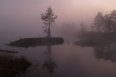 Sunsets and sunrises in the swamp are unforgettable. And on a warm summer night you may want to experience the feeling of sleeping in one of the (at least three) observation towers in the area. The towers have a roof, so worries about the rain are not that big, although wind may spray rain to parts of the "covered" areas. Sometimes there may be mosquitoes here, which are annoying but carry no disease but. Even in spring and fall, the towers could be used, depending on your equipment. Bring your own water and food. Please note that the towers south to the highway (located on the yellow hiking trail) are much quicker to reach from North than from South (if you intend to sleep there, just consider the time needed, from Loksa tee it's probably about 2-3 hours to walk).
- Viru raba observation tower (Viru raba vaatetorn), 59.468522°, 25.654574°. This tower can offer space for 10–15 people during the night. It is very clean, due to its soil free location in the swamp, and well maintained, due to its touristic nature. 2017-09-29
- Kõnnu Suursoo observation tower (Kõnnu Suursoo vaatetorn), 59.411128°, 25.688460°. This tower is beautifully located inside the huge Kõnnu Suursoo. It is clean. The roof has a small hole (as of Sep 2017), which makes one side of the tower not practicable for overnighting during rain, and thus can only offer space for 4-5 people. 2017-09-29
- Paukjärve observation tower (Paukjärve vaatetorn), 59.399279°, 25.689722°. This tower can offer space for 6–10 people during the night. It is a little dirty due to the forest soil around it and people carrying the dirt into the tower. Due to its height and location on top of a hill, there should be fewer mosquitoes here. 2017-09-29
Stay safe
In these forest there is a great possibility of catching a tick that can carry a disease (TBC or ehrlichia or borreliosis). Therefore a sufficient repellent is highly suggested. Also it is recommended to wear long, light clothes and examine your body in the evening to find any ticks.
The bogs may be tricky to get out of, and even dangerous, so better not step off the track. If you intend to go swimming in one, no not go alone and go where the is at least a provisional entry.
Go next
- Jägala Falls (Jägala juga) 📍 – some 20 km east of Tallinn, this is Estonia's largest waterfall. It is better to go early in the morning to catch the soft dawn light or in the evening when the sun shines on the falls. During cold winters, Jägala Falls freezes in a spectacular fashion and is well worth seeing.
- Rakvere – Estonia's fifth largest city, east of Tallinn, famous for its Punk and Rock festivals and spirit.
- Tallinn – The capital, and financial and cosmopolitan centre of Estonia, with a medieval Old Town. Beautiful and expensive.
Lahemaa National Park
kaitsealad.ee/eng/lahemaa-national-parkTimezone:MultipleCoordinates:59.57, 25.80