The Financial District comprises the southern tip of Manhattan, with the Hudson River on the west, the East River on the east, New York Harbor to the south, and Barclay Street on the north. It is one of the two largest business districts in New York City - the other being Midtown Manhattan - and is the historical core of the modern city, a fact reflected in the convoluted street pattern compared to the grid of regular streets and avenues found uptown.
The "lowest" part of Lower Manhattan is home to some of New York's most famous and evocative landmarks: Wall Street, the Brooklyn Bridge, as well as the Statue of Liberty on Liberty Island and Ellis Island in the harbor, both accessed by ferry boat from the financial district.
Understand
History
The southern tip of Manhattan was the site of earliest European settlement in the New York area - the Dutch settlement of New Amsterdam. Established in 1625, the settlement became the capital of New Netherland, the colonial Dutch province which controlled the area along the Hudson River. In 1664, the British conquered New Netherland and New Amsterdam became "New York".
In the late 18th century, with the American Revolution brewing, New York became a major political center for the colonists. Protests against the Stamp Act led the so-called "Stamp Act Congress" to convene here and sign a Declaration of Rights and Grievances, asserting the concept of "no taxation with representation." British soldiers captured New York and maintained control of the city until the war ended, when George Washington triumphantly returned to Manhattan. He would return again in 1789 to take the oath of office and become the nation's first president, as New York briefly served as the first capital of the United States, where the Bill of Rights was drafted and ratified.
Shortly after the creation of the United States, Lower Manhattan started becoming an economic and financial center for the new nation. In 1792, a group of stock brokers signed the Buttonwood Agreement, which created the New York Stock Exchange, underneath a buttonwood tree at 68 Wall Street. In the late 19th and early 20th centuries, the corporate culture of the area fueled the construction of many skyscrapers in the district, and as the financial power of New York grew, so did its influence; as evidenced by the 1929 Wall Street Crash, which ushered in the Great Depression.
Through the 1940s and 50s, new economic growth on Manhattan was centered in Midtown. Desiring to concentrate new growth in Lower Manhattan, and coming in at the height of the urban renewal movement, local leaders demolished most of the old structures to make way for the gleaming office towers of today's Lower Manhattan, not the least of which included the World Trade Center. The World Trade Center, a complex of two identical skyscrapers (the Twin Towers) and five low-rise buildings constructed in the 1970s, defined the Lower Manhattan landscape until it was destroyed during the terrorist attacks of September 11, 2001. A new World Trade Center complex is in the process of being built on the site, opening in stages alongside a large museum and outdoor memorial to the September 11th victims.
Layout
This part of Manhattan has an irregular street grid system, a throwback to the original Dutch settlement of New Amsterdam. This street pattern seems even more irregular when compared to the neat grid system seen just about everywhere else in Manhattan. Major avenues here run in a north-south direction - West Street along the Hudson River, Church Street and Broadway through the middle of the district, and Water Street and South Street (the former running beneath the elevated FDR Drive) along the East River. With the exception of these roads, almost every street in the financial district is very narrow and often clogged with traffic during the day. The blocks immediately surrounding the intersection of Wall and Broad Streets (where the stock exchange and Federal Hall are located) are blocked off to automobiles; only pedestrians may enter.
Visitor information
- NYC Information Center–City Hall, southern tip of City Hall Park (on the Broadway sidewalk at Park Row), 40.71144°, -74.00850°, +1-212-484-1222. M–F 9AM–6PM, Sa–Su 10AM–5PM, holidays 9AM–3PM. Guides, maps, pamphlets, brochures, and bilingual staff available for questions.
- NYC Information Center–South Street Seaport, South Street Seaport, Pier 15 (next to Hornblower Cruises on the East River Waterfront Esplanade), 40.70555°, -74.00274°, +1-212-484-1222. May–Aug: 9AM–7PM daily; Sep–Apr: 9AM–5PM daily. Guides, maps, pamphlets, brochures, and bilingual staff available for questions.
Get in
By subway
Most of the city's subway lines have stops in the Financial District, making it one of the best ways to get there. There are few express stations in the area, so most trains will stop at every station in this neighborhood. Though many city bus lines serve the area, traffic is often slow on the winding streets.
The 1, 2, 3, 4, 5 and 6 lines connect the district to Uptown and the Bronx, with the 2, 3 and 4 also running to Brooklyn under the East River (along with the 5 during rush hours). The A and C lines run Uptown and east out to Brooklyn, with the A continuing to the JFK Airport area. The E runs alongside the A and C lines to Midtown, where it breaks off and runs out to Queens, towards JFK Airport. The R heads north to Midtown and Queens on the weekdays. Finally, the J and Z lines head northeast to Brooklyn and Queens.
Additionally, PATH subway trains connect the World Trade Center site to New Jersey. There are two lines: one to Newark and one to Hoboken, both with stops in Jersey City. The PATH costs $2.75 per ride and accept MetroCard for payment.
There is a free circulator bus around the Financial District called the Downtown Connection (dead link: January 2023).
By ferry
The Staten Island Ferry connects the South Ferry Terminal 📍, located at the southern tip of Manhattan, to the St. George Ferry Terminal on Staten Island. The ferry is absolutely free and is popular for tourists since the route offers excellent views of Lower Manhattan and the Statue of Liberty. The ferry runs 24 hours a day, usually running at 30 minute intervals, with more running during rush hours and fewer running at very late hours.
NY Waterway operates ferry services from the World Financial Center ferry terminal and the Pier 11/Wall St. ferry terminal to several points in New Jersey along the Hudson River, including in Hoboken and Weehawken. Fares vary by route.
New York Water Taxi operates ferry services from World Financial Center, Battery Park, Pier 11/Wall St. and the South Street Seaport to points in Midtown, Brooklyn, Queens, Yonkers, and Breezy Point. Their boats are painted to look like taxis and fares vary by route.
See
Landmarks
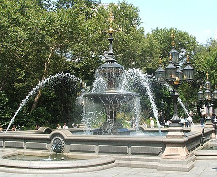
- City Hall, 40.71273°, -74.00599°, +1-212-788-2656, tours@cityhall.nyc.gov. On a triangular city block between Broadway, Park Row and Chambers Street sits City Hall, a gorgeous gleaming white building completed in 1812, which still hosts the mayor's office and the New York City Council chambers. The building itself is fenced off and only accessible by tour, but there is a lovely park surrounding the building, with plenty of shady trees and a pleasant fountain just to the south of the building. Just north of City Hall and on the same block is the Tweed Courthouse 📍, a gorgeous government structure and the legacy of Tammany Hall boss William M. Tweed, who used the courthouse project to embezzle large sums of money from the city budget and was convicted in a courtroom in this building.
- City Hall Station, 40.7133°, -74.0067°. The original subway station, and quite a marvel to witness--the chandeliers and ornate tiling are a sharp contrast to the nearby Brooklyn Bridge-City Hall station. There's one catch, though: it's been closed since 1945. However, you can see it by staying on the downtown 6 train after its last stop Brooklyn Bridge-City Hall; it will turn around in the old station. This is the one place in the system where this is allowed, and the announcements reflect that. The Transit Museum (in Downtown Brooklyn) offers occasional tours as well, which allow you to actually walk around the station, but you must be a museum member and a US citizen, making this an impractical choice for most visitors.
- Manhattan Municipal Building (David N. Dinkins Manhattan Municipal Building), 1 Centre St (at Chambers St), 40.713°, -74.0039°. With New York City growing and not enough space in the City Hall building, this 40-story structure was built to meet the space demands of the city government. Completed in 1915, it is a massive and very grand building with the gilded statue of a woman standing atop the building's spire.
- {{see
| name=Wall Street | alt= | url= | email=
| address= | lat=40.706389 | long=-74.009444 | directions=Subway: or to Wall St or to Broad St
| phone= | tollfree= | fax=
| hours= | price=
| wikipedia=Wall Street | image=Sign Brodway crossing Wall Street.JPG | wikidata=Q11690
| content=The historic heart of the Financial District and the home of the New York Stock Exchange, Wall Street is a metonym for American big business, stock trading and the entire financial industry, although most New York financial firms are no longer headquartered on the street itself, but housed nearby in new offices, and some have moved to Jersey City. A narrow street running downhill from Broadway to the East River, Wall Street was named for the wall that was built here in 1652 to keep Manhattan's indigenous peoples out of the growing Dutch settlement. The wall was demolished by the British in 1699. By the late 18th century, traders and speculators would gather under a buttonwood tree at the foot of Wall Street to trade informally - this was the origin of the New York Stock Exchange that was established in 1817.
}}
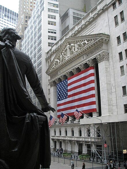
- New York Stock Exchange (NYSE), 18 Broad St (at Wall St), 40.70697°, -74.01111°. A historic site, not least because of the Black Thursday crash of the Exchange on 24 October 1929 and the subsequent sell-off panic which started on Black Tuesday, 29 October, precipitating the worldwide Great Depression of the early 1930s. The present Exchange building opened in 1903, recognized from the first as an example of masterful architecture, with the six massive Corinthian columns across its Broad Street facade imparting a feeling of substance and stability and, to many, seeming the very embodiment of America’s growth and prosperity. The building has been closed to the public since 9/11.
- 23 Wall Street, 40.707°, -74.0106°. Located across from the Stock Exchange is this imposing office building which was constructed in 1914 and served as the headquarters of JP Morgan. The Wall Street Bombing of September 16, 1920 damaged the building, with shrapnel blasting several holes in the limestone facade. The holes are still there for any to see.
- 40 Wall Street (Trump Building), 40 Wall St, 40.706944°, -74.009722°. A very impressive skyscraper with a green spire which was completed in 1930 and surpassed the height of the nearby Woolworth Building (see Manhattan/TriBeCa#See), making it the tallest building in the world until the Chrysler Building was completed just a month later (which in turn lost that title to the Empire State Building less than a year later). The building was leased by Donald Trump in 1995, hence its current name.
- Federal Hall, 26 Wall St (opposite the NYSE), 40.7072°, -74.0103°, +1-212-825-6990. M-F 9AM-5PM. On this site on April 30, 1789, George Washington stood on a balcony overlooking Wall Street and was inaugurated as the first president of the United States. The old building on the site had been used as New York's city hall and had hosted some of the first congregations of the colonies in the lead-up to the American Revolution, such as the Stamp Act Congress. After the revolution the building, now Federal Hall, briefly housed Congress, the Supreme Court, and Executive Branch offices before the national capital moved to Philadelphia. The current building dates to 1842 and was used first as a Customs House, then later the US Sub-Treasury (millions of dollars of gold and silver were kept in the basement vaults). Today the building is maintained by the National Park Service as a museum dedicated to the history of the site. Guided tours of the building are available, or you can just walk in and look up at the rotunda and view some of the artifacts, such as the bible Washington used in his inauguration ceremony. Free
- {{see | name=Trinity Church | alt= | url=http://www.trinitywallstreet.org/ | email= | address= | lat=40.708333 | long=-74.0125 | directions=Broadway at Wall St; Subway: to Wall St | phone=+1-212-602-0800 | tollfree= | fax= | hours=M-F 7AM-6PM, Sa 8AM-4PM, Su 7AM-4PM | price=Free | wikipedia=Trinity Church (Manhattan) | image=Trinity Church NYC 004b.JPG | wikidata=Q866896 | content=An Episcopalian (Anglican) church and parish was first established on this site in 1697 under charter by King William III. The present Neo-Gothic Revival church building (the third incarnation) dates from 1846 and remains a significant landmark within Downtown. The original burial ground at Trinity Church includes the graves and memorials of many historic figures, including Alexander Hamilton, William Bradford, Robert Fulton, and Albert Gallatin. }}
- {{see | name=Bowling Green | alt= | url=https://www.nycgovparks.org/parks/bowling-green | email= | address= | lat=40.705 | long=-74.013611 | directions=at Broadway and Morris; Subway: to Bowling Green | phone= | tollfree= | fax= | hours= | price= | wikipedia=Bowling Green (New York City) | image=Wpdms 20020923b bowling green composite.jpg | wikidata=Q895455 | content=A small park at the foot of Broadway which is the oldest public park in the city and is the site of the Charging Bull sculpture created after the 1987 stock market crash. Bowling Green is also the origin point for the Broadway ticker-tape parades; if you walk up Broadway, you can view plaques in the sidewalk honoring the people or events celebrated in these parades. }}
- {{see
| name=Battery Park | alt= | url=http://www.thebattery.org/ | email=
| address= | lat=40.70385 | long=-74.01588 | directions=Subway: to Bowling Green or to South Ferry – Whitehall Street
| phone= | tollfree= | fax=
| hours= | price=Free
| wikipedia=Battery Park | image=Battery Park.JPG | wikidata=Q13689
| content=At the southern tip of Manhattan, Battery Park is a waterfront green space, named for the artillery batteries which were installed here to protect the settlement of New York when it was under Dutch, then British rule. In the lead-up to the War of 1812, Castle Clinton 📍 was constructed as a fort to protect the city, and is now operated as a small museum. There are several memorials in the park, including The Sphere 📍, a public art piece originally housed on the World Trade Center site which survived the events of September 11 and was moved to Battery Park. Ferries departing to the Statue of Liberty and Ellis Island (see below) depart from here.
}}
.jpg/440px-M%C3%A9morial_du_World_Trade_Center_(8856311127).jpg)
- {{listing | type=see | name=National September 11 Memorial & Museum | alt=World Trade Center site - note that the term 'Ground Zero' is never used by New Yorkers | url=http://www.national911memorial.org | email=info@national911memorial.org | address=180 Greenwich St | lat=40.711389 | long=-74.013611 | directions=between West, Greenwich, Liberty, and Fulton Streets; Subway: to Park Pl or or to Fulton St or to Cortlandt St or to Chambers St or to World Trade Center | phone=+1-212-312-8800 | tollfree= | hours=Memorial: 7:30AM-9PM daily; museum: Su-Th 9AM-8PM, F Sa 9AM-8PM, last museum entry 2 hours before closing | price=Memorial: free; Museum: adult $24, senior or 13-17 or college $20, veteran $18, 7-12 $15; free admission Tuesday evenings after 5PM | wikipedia=National September 11 Memorial & Museum | image=WTCmemorialJune2012.png | wikidata=Q1136137 | lastedit=2018-10-21 | content=On the site of the former World Trade Center towers, the memorial consists of two enormous waterfalls and reflecting pools set within the footprints of the twin towers, lined with bronze panels with the names of the nearly 3,000 victims of that fateful day inscribed. The surrounding plaza holds a grove of trees. The museum, which sits underground right next to the memorial, contains exhibits which explain the events of 9/11 and their aftermath, with remnants of the original towers and artifacts from that day. If you see a white rose on one of the names, it's because today is that victim's birthday. }}
- One World Trade Center, 285 Fulton St (at Vesey and West Sts), 40.713°, -74.0135°, +1-844-696-1776. Daily 9AM-8PM, open daily until midnight in the summer months; last ticket sold 45 min prior to close. The One World Trade Center skyscraper rises 1,776 feet above the street and is the tallest building in the United States (and for that matter, the Western Hemisphere). Despite its colossal size, its simple design allows it to blend remarkably well into the Lower Manhattan skyline. An observation deck on the top floors offers 360-degree views of the city. $32 adults, $30 seniors, $26 children 6-12, free for children 5 and under 2015-05-29
- {{see | name=St Paul's Chapel | alt= | url=https://www.trinitywallstreet.org/about/stpaulschapel | email= | address=209 Broadway | lat=40.711394 | long=-74.009947 | directions=between Fulton and Vesey Sts; Subway: to Fulton St | phone=+1-212-602-0800 | tollfree= | fax= | hours=10AM-6PM | price=Free | wikipedia=St. Paul's Chapel | image=WTM tony 0137.jpg | wikidata=Q1325500 | content=Built in 1776, the chapel is an active part of the Parish of Trinity Church and is Manhattan's oldest public building in continuous use. It is the only remaining colonial church in New York City and was George Washington's place of worship after he was inaugurated as president. Since 2001, the chapel has been known for surviving the events of 9/11 without even a broken window - despite being across the street from the World Trade Center - and for its role as a place of refuge for the WTC recovery workers in the days that followed. }}
- New York by Gehry, 8 Spruce St (south of City Hall), 40.710922°, -74.005686°. A 2011 addition to the Lower Manhattan skyline, this 76-story residential skyscraper by the noted Frank Gehry has a distinctive rippled, "wavy" facade that is quite eye-catching. It is best viewed from City Hall Park and the Brooklyn Bridge.
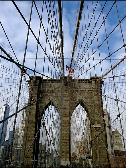
- {{see | name=Brooklyn Bridge | alt= | url=http://www.nycroads.com/crossings/brooklyn | email= | address= | lat=40.70788 | long=-73.99928 | directions=Subway: to Brooklyn Bridge – City Hall or to Chambers St | phone= | tollfree= | fax= | hours= | price=No toll | wikipedia=Brooklyn Bridge | image=NYCBrooklynBridge.jpg | wikidata=Q125006 | content=From its intersection with Park Row (just east of City Hall) you can walk (takes about 20-30 minutes each way), bike, or drive across the historic and iconic bridge to Brooklyn. The view from the bridge is quite lovely, with excellent views of Lower Manhattan and Downtown Brooklyn and good views of Midtown and the New York Harbor in the distance. }}
- Irish Hunger Memorial, 40.715139°, -74.016528°. 2018-07-22
- Queen Elizabeth II Garden (formerly British Garden at Hanover Square), 40.7046°, -74.0095°. 2018-09-30
Museums

- African Burial Ground National Monument, 290 Broadway, 1st floor (north of City Hall), 40.7144°, -74.0044°, +1-212-637-2019. Visitor Center: Tu-Sa 10AM-4PM except Federal holidays; Memorial: Daily 9AM-5PM except Federal holidays. Memorial closed November–March. For most of the 18th century, Africans in New York City were buried in a graveyard outside the city. The graveyard was eventually forgotten and was rediscovered in 1991. This museum and memorial site commemorate the estimated 15,000 Africans that were interred on the site of the memorial. Note that the museum is located inside of a Federal building so airport-style security should be expected. Free
- Fraunces Tavern, 54 Pearl Street, 40.703333°, -74.011389°. 2018-09-04
- Museum of American Finance, 48 Wall St, 40.7064°, -74.0092°, +1-212-908-4110. Tu-Sa 10AM-4PM. A small museum dedicated to finance and the markets, with exhibits that change periodically. $8 adults, $5 students/seniors, children 6 and under free
- Museum of Jewish Heritage, 36 Battery Pl, 40.70621°, -74.01875°, +1-646-437-4200. Su-Tu Th 10AM-5:45PM, W 10AM-8PM, F 10AM-5PM. A memorial to the Holocaust. $12 adults, $10 seniors, $7 students, children 12 and under free; free admission W 4-8PM
- {{see | name=National Museum of the American Indian | alt= | url=http://nmai.si.edu/visit/newyork/ | email= | address=One Bowling Green | lat=40.7043 | long=-74.0138 | directions=adjacent to the northeast corner of Battery Park; Subway: to Bowling Green | phone=+1-212-514-3700 | tollfree= | fax= | hours=F-W 10AM–5PM, Th 10AM-8PM | price=Free | wikipedia=George Gustav Heye Center | image=Us-customhouse.jpg | wikidata=Q5539979 | content=Housed in the Alexander Hamilton US Custom House, this Smithsonian museum is the New York branch of the National Museum of the American Indian (the other branches are in Washington, D.C. and Maryland). }}
- New York City Police Museum, 45 Wall St, 40.703538°, -74.008192°, +1-212-480-3100. Temporarily closed. A museum dedicated to the history of the NYPD. $8 adults, $5 seniors/students/children, children under 2 free
- Skyscraper Museum, 39 Battery Pl, 40.705556°, -74.0175°, +1-212-968-1961. W-Su noon-6PM. Exhibits on the history of highrise and skyscraper construction. $5 adults, $2.50 students/seniors
- South Street Seaport Museum, 12 Fulton St, 40.7061°, -74.0028°, +1-212-748-8600. Jan-Mar: F-M 10AM-5PM, Ships noon-4PM; Apr-Dec: Tu-Su 10AM-6PM. A museum with exhibits on the historic Seaport area and a collection of ships at the South Street Seaport on the East River open for tours. $10 adults, $8 students/seniors, $5 children, children under 5 free
- Federal Reserve Museum and Gold Vault Tour, 44 Maiden Lane, 40.708333°, -74.008611°, frbnytours@ny.frb.org. Tours M-F at 1PM & 2PM, except bank holidays. Arrive 30 minutes early for security screening. Free 2016-12-31
New York Harbor

The Financial District is the primary gateway to three islands in New York Harbor: Liberty Island (home to the Statue of Liberty), Ellis Island, and Governors Island. Another ferry runs to Liberty and Ellis Islands from Liberty Park in Jersey City, but most tourists use the Manhattan ferries. These are some of the most popular destinations in New York City and access is available only by ferry boat.
If you're visiting New York on a budget or you don't want to wait for hours to get near the Statue of Liberty, you may want to consider taking the Staten Island Ferry, which is absolutely free and offers excellent views of the Statue of Liberty from its route to Staten Island from the South Ferry Terminal, just east of Battery Park.
- Statue Cruises, 40.70320°, -74.01735°, +1-212-269-5755. 8:30AM-5:15PM (hours adjusted seasonally); if you leave after 2PM, you will only be able to visit either Liberty Island or Ellis Island. The only means of access to Liberty and Ellis Islands; the ferries depart from Battery Park at the southern tip of Manhattan or from Liberty State Park in Jersey City. Be prepared for airport like security screening with similar restrictions (no food or open liquids, no knives, etc.) before boarding the boat. One ticket is good for sailings to both islands and return to starting point. Tickets are limited in number and can be obtained on the day from the ferry company or in advance by calling the ticket office on the phone number above or online. If leaving from Manhattan, you may need to arrive at Battery Park 2 hours before your timed tour to allow for security screening and ferry travel, so it is best to arrive at Battery Park early in the morning. $18 adults, $14 seniors (62+), $9 children (4-12). Includes audio tour. Crown Access requires advance reservation 2018-08-11
- Statue of Liberty (Liberty Enlightening the World), 40.689209°, -74.044439°. One of the most famous and iconic landmarks in the USA, if not the world. A gift from the people of France to celebrate the centennial of the United States, stands upon Liberty Island and is one of the most famous symbols of the nation and has been inscribed on the UNESCO World Heritage list. Upon departing the ferry, you can visit the Visitor Information Station, which has a schedule of the day's events. Visitors can also meet at the Liberty Island Flagpole (behind the statue) for a ranger-led tour of the island. You can also visit the monument lobby, museum (where you'll see various exhibits on the statue, the old torch, and the famous "New Colossus" sonnet), and outside to the promenade and Fort Wood (the 11-point star-shaped structure the statue stands upon). You can also take a trip to the pedestal observation deck (though not up into the statue itself, unless you have a Reserve with Crown ticket); visitors can look upward to view the interior of the statue (there are four marked viewing locations); and the pedestal observation deck provides a 360-degree view, which includes the New York City skyline. Security checks are rigorous, so travel as light as possible. Backpacks and other large bags are not permitted on the tours but can be stored in lockers for a fee. On busy days there may be long waits. Visitors with the Reserve with Crown ticket are allowed to climb up a circular staircase from the base of the statue to the crown, but tickets are very limited and should be reserved three or four months (up to one year) in advance. Children must be at least 4-feet tall, and must be able to walk up and down the stairs by themselves, and all ticket holders must show a photo ID to match the name on their tickets.
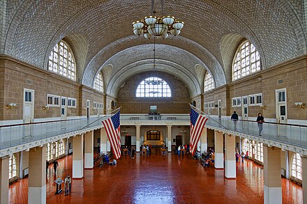
- Ellis Island, 40.698611°, -74.04°. Ellis Island was home to the nation's primary federal immigration station, with over 12 million immigrant steamship passengers passing through from its opening in 1892 to its closing in 1954. Today, over 40 percent of America's population can trace their ancestry through Ellis Island. The island is home to the American Family Immigration History Center, which contains manifests of 25 million immigrants, passengers, and crew members who entered New York Harbor. The Immigration museum at Ellis Islands has details about "Peopling of America" and if you are an avid history lover, this museum will need at least 3-4 hrs of your time. Since the ferry ride takes you to both Ellis Island as well as the Liberty Island, you will have to plan your day well.
- Governors Island, ferries depart from the Battery Maritime Building at 10 South St, 40.691389°, -74.016111°, +1-212-825-3045. Open seasonally; W-Th guided tours take place at 10AM and 1PM, F ferries leave every hour 10AM-3PM, Sa-Su ferries leave every hour 10AM-5PM, from Brooklyn ferries leave every 20 minutes. Governors Island has a long military history, home to headquarters and military posts of the United States Army from 1794 until 1966, then a complex for the U.S. Coast Guard before becoming a historic district open to tours. Free
Ticket Options
 Visitors to Liberty Island and Ellis Island have two reserve ticket options:
-
- Reserve Ticket – includes ferry transportation; provides access to Liberty Island and Ellis Island, including the grounds of Liberty Island and the Ellis Island Immigration Museum. The Reserve Ticket allows you to save time when waiting for the ferry; instead of waiting on the longer line, the Reserve Ticket allows you to go through the priority entrance at the security check-in. The Reserve Ticket does not allow entry to the crown of the statue. The cost of the Reserve Ticket is the same as the Ferry ride; there is no additional cost for the Reserve Ticket.
-
- Reserve with Crown Ticket – includes ferry transportation; in addition to the access that is provided with the Reserve Ticket, this ticket also allows access up to the Crown of the Statue of Liberty. Visitors to the crown will be required to go through a secondary security screening. Reserve with Crown Tickets are very limited and should be obtained three or four months or longer (up to one year) in advance.
Tickets can also be purchased through concierges at major hotels and at the ticketing windows in the Castle Clinton National Monument inside Battery Park, New York, or inside the Central Railroad of New Jersey Terminal in Liberty State Park, Jersey City, New Jersey.
Note: There is a separate Reserved Ticket entrance (at the security check-in) for the Reserve Ticket and Reserve with Crown Ticket. If you purchase one of these reserved tickets, then you can take advantage of this priority entry (Reserve Ticket entrance) and you could easily save an hour of waiting during busy times.
Learn
- The Institute of Culinary Education, 225 Liberty St, 40.71193°, -74.01531°. Founded in 1975, The Institute of Culinary Education (ICE) is New York’s largest cooking school. ICE career cooking programs feature classes in culinary arts, pastry arts & baking, and culinary management. 2019-09-18
Buy
- Brookfield Place (formerly World Financial Center), 230 Vesey St (just west of the World Trade Center site), 40.7116°, -74.0156°, +1-212-978-1698. Shopping, dining, events and the Winter Garden all open to the public.
- Westfield World Trade Center, 185 Greenwich St, 40.7113°, -74.0119°, +1 212-284 9982. 2018-07-22
Eat
Broad Street has several chain eateries.
Budget
- Terry's, 41 River Terrace, 40.71817°, -74.01458°, +1-212-267-2816. Deli popular with local students. 2022-08-01
- Shorty's, 62 Pearl St, 40.7035069°, -74.0110014°. Cheesesteak restaurant 2022-08-01
- Rockwell's, 105 Broad St, 40.7031249°, -74.0113967°. Independent eatery since 1995. 2022-08-01
- Blue Park Kitchen, 70 Pine St, 40.7063452°, -74.0078662°. 2022-08-01
- d Elici, 71 Nassau St, 40.7096571°, -74.0083661°. Sandwiches 2022-08-01
- Joe’s Pizza, 124 Fulton St, 40.7101214°, -74.0076774°. 2022-08-01
- Tartinery, 225 Liberty St, 40.7122437°, -74.0159269°. 2022-08-01
- Underground Pizza, 3 Hanover Square #2615, 40.7049226°, -74.0097870°. 2022-08-01
Mid-range
- Bill’s Bar & Burger, 85 West St (in the Marriott Hotel Downtown), 40.709612°, -74.014484°, +1-212-894-3800. Sa Su 7AM-11PM, M-F 6:30AM-11PM. Classic American fare, includes handmade griddle burgers, milkshakes and a wide beer selection. $5-15 (Aug 2015) 2022-08-01
- Watermark, 78 South St Pier 15, 40.7044979°, -74.0031411°. Stylish restaurant overlooking the East River 2022-08-01
- Hole In The Wall, 15 Cliff St, 40.7084280°, -74.0055903°. 2022-08-01
- Playa Bowls, 1 New York Plaza, 40.7021135°, -74.0118556°. 2022-08-01
- Fraunces Tavern, 54 Pearl St, 40.7034340°, -74.0114195°. 2022-08-01
- O'Hara's, 120 Cedar St, 40.7095549°, -74.0126590°. Irish restaurant 2022-08-01
Splurge
- {{eat | name=Nobu |url=http://www.noburestaurants.com/downtown/experience-3/ | email= | address=195 Broadway | lat=40.710973 | long=-74.009602 | directions=entrance on Fulton between Broadway and Church; Subway: to Fulton St | phone=+1-212-219-0500 | tollfree= | fax= | hours=Lunch: M-F 11:30AM-2:15PM; Dinner Su-W 5:30PM-10:15PM, Th-Sa 5:30PM-11:15PM | price= | lastedit=2022-08-01 | content=World-renowned Japanese restaurant requiring reservations well in advance. For an alternative, try Nobu Next Door which doesn't require a reservation and serves the same creative, delicious food. May not be worth all the hype, but certainly worth some. }}
Drink
Sleep

- Andaz Wall Street, A Hyatt Hotel, 75 Wall St (entrance on Water St), 40.70525°, -74.00780°, +1-212-590-1234, guestservices.wallst@andaz.com. Check-in: 3PM, check-out: noon. The only hotel on Wall Street featuring 253 rooms that begin at a very large 345sq.ft./32sq.metres. All rooms come with free internet, free minibar (except alcohol), free gym access, and free light refreshments in the lobby. $250-350
- Conrad New York, 102 North End Ave (Between Murray and Vesey St), 40.71500°, -74.01532°, +1-212-945-0100, conradnewyork.reservations@conradhotels.com. Check-in: 3PM, check-out: noon. Brand new all-suite luxury hotel overlooking the Hudson River in Battery Park City, located next to the World Financial Center and minutes from Wall St, Statue of Liberty and 9/11 Memorial.
- Eurostars Wall Street, 129 Front St (at Pine St), 40.70513°, -74.00611°, +1-212-742-0003, info@eurostarswallstreet.com. A small boutique luxury hotel a block north of Wall Street. $230-400
- Gild Hall, A Thompson Hotel, 15 Gold St (at Platt St), 40.70786°, -74.00707°, +1-212-232-7700, infoGildHall@thompsonhotels.com. $250-300
- Holiday Inn Wall Street, 51 Nassau St, 40.70900°, -74.00918°, +1-212-227-3007. A boutique hotel two blocks from Wall Street, one block from the New York Stock Exchange, and across the street from the Federal Reserve Bank. Consists of 113 rooms with free wireless internet, contains a fitness center, and is pet friendly. $150-250
- Millenium Hilton, 55 Church St (Across from the World Trade Center site), 40.71114°, -74.01025°, +1-212-693-2001. Check-in: 3PM, check-out: noon. 55-Story hotel located in the heart of the Financial District, next to the 9/11 Memorial and 11 different subway lines, featuring a heated indoor pool and 569 guest rooms and suites with skyline views.
- New York Marriott Downtown, 85 West St, 40.70946°, -74.01437°, +1-212-385-4900. Good views and nice rooms. $300-450
- Residence Inn by Marriott World Trade Center, 170 Broadway (at Maiden Lane), 40.70956°, -74.00992°, +1-212-600-8900, sales@riwtc.com. Check-in: 4PM, check-out: noon. 242 rooms with kitchenettes and suites, 240sq.ft. to 600sq.ft with 10' ceiling height. All rates include a full hot American breakfast buffet daily, free basic wi-fi and fitness center. $250-450
- World Center Hotel, 144 Washington St (South side of the World Trade Center site), 40.7098°, -74.0139°, +1-212-577-2933, info@worldcenterhotel.com. Check-in: 3PM, check-out: noon. 2016-11-20
Connect
- New York Public Library - Battery Park City Branch, 175 North End Ave, 40.715614°, -74.015853°, +1 212-790-3499. Like other branches of the New York Public Library, they have Wi-Fi and computers for public use, among other services. 2019-09-18