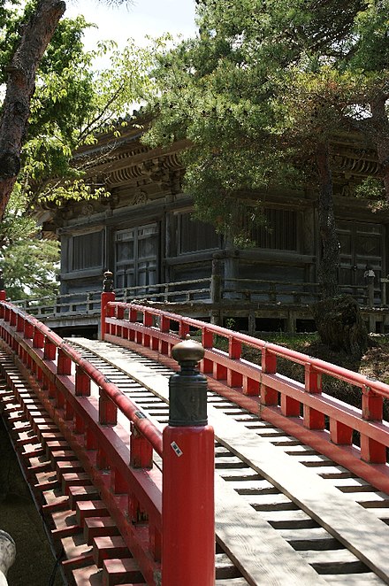
Matsushima (松島;) is a small town in Miyagi prefecture, northeastern Japan. The town faces Matsushima Bay, famous for some 260 tiny islands (島 shima) covered in pines (松 matsu) — hence the name — and ranked as one of Japan's Three Great Views.
Understand
In 1689, haiku poet Matsuo Basho visited Matsushima on the trip recorded in Narrow Road to the Deep North. A well-known poem often attributed to Basho claims to record his reaction, signifying that nothing more could be said:
Today's Matsushima is perhaps a little less inspiring, but still a worthwhile day trip if in the region.
The town did not suffer significant damage due to the Great East Japan Earthquake; the tsunami damage was minimal. The temples, shrines, and sights are still there and still worth the trip.
Get in
The town is only a short distance from prefectural capital Sendai.
By train
Most visitors arrive on the JR Senseki Line (仙石線) connecting Sendai and Ishinomaki. The most convenient station is Matsushima-Kaigan (松島海岸), which is 40 minutes from Sendai (¥420). During daytime hours there are usually only two departures per hour to Matsushima-Kaigan. Another hourly service runs as far as Hon-Shiogama (see below). If you buy a ticket in Sendai, be sure to have the name written in characters: the machines do not have an English option.
On the other hand, Matsushima station on the JR Tohoku Main Line is further away from the shore and requires a walk of at least 20 minutes, or a short taxi ride, to reach the ferry.
From Tokyo, the Shinkansen bullet train runs to Sendai for connection to the Senseki Line. The total one-way fare is ¥11,520 using the fastest, all-reserved Shinkansen service, and the journey to Matsushima-Kaigan lasts around 2 hr 45 min. There is no charge if you use the Japan Rail Pass.
By boat
Ferries tour around the islands every hour or so, and some of them do the trip to and from Hon-Shiogama on the JR Senseki line (don't mistake it with JR Tohoku line train to Shiogama station). The ferries are focused on sightseeing, and you won't miss any of the islands in the bay by taking the ferry to Hon-Shiogama. If you are flexible, you can do this trip on your return leg, as it is much more pleasant to be waiting at the wharf in Matsushima than at Hon-Shiogama (although the latter does have an air-conditioned waiting room, and a cafe).
From Hon-Shiogama train station to the wharf is a 500-m walk. You can see one from the other, or follow the signs.
Get around
Matsushima's seaside attractions are within walking distance of the train station and ferry pier, but the best views are from mountaintops not so easy to reach on foot. The most spectacular views are from Saigyo Modoshi no Matsu Park, a ¥660 cab ride up from the station. It is covered with cherry blossoms in the spring, but the food available there is nothing special. Other overlooks are Sōkanzan, a promontory that juts out into the bay, and Ōgitani, a hill across the coastal highway from Sokanzan.
See

- Zuigan-ji Temple (瑞巌寺), Chōnai-91, 38.371966°, 141.060209°. 08:00-15:30 (sometimes later). Matsushima's top Zen temple with over a thousand years of history, but not a top choice for relaxation: tickets are sold from vending machines and guides shouting into megaphones herd tour groups through the temple, which has been turning into a museum with everything of interest partitioned off and/or packaged in glass cases. The approach with its moss-covered Kannon statues is atmospheric though. ¥700
- Kanran-tei Pavilion (観瀾亭), 38.369458°, 141.061337°. It was built in Kyoto by famed Shogun Toyotomi Hideyoshi. It was moved to Matsushima by Date Tadamune in 1645 and is the largest Momoyama-style tea house in Japan. An excellent place to stop for a ¥200 cup of tea (traditional Japanese sweets included) and a view of the Matsushima coastline.
- Fukuura Island (福浦島; Fukuura-jima), 38.366711°, 141.070945°. Connected to the mainland by a long bridge, the island is crisscrossed in all directions by paths small and large, paved and muddy, well-trod and overgrown. A circuit of the island won't take more than an hour and there are some very sparsely beautiful spots to be seen. An interesting anecdote, there is a local superstition that crossing the bridge with a girlfriend/boyfriend will cause a breakup. ¥200
- The Museum Matsushima (ザ・ミュージアムMatsushima), 38.372209°, 141.066847°. The museum contains three separate collections; the Orgel Collection of music players, the Segawa Collection of fashion from 1870-1960, and the Kitahara Toy Collection, featuring a variety of old, nostalgic toys. 2019-10-10
- Kyohei Fujita Museum of Glass (藤田喬平ガラス美術館), 38.376946°, 141.071972°. 2019-10-10
- Godaido Hall (五大堂), 38.369736°, 141.064258°. A picturesque building built on its own peninsula overlooking the bay, it is a well-known symbol of the city. It was founded 807 and the current structure dates back to 1604. Free 2019-10-10
Do
- Ōtakamori (大高森), 38.340026°, 141.152288°. One of the 4 Famous Places to view Matsushima Bay and a good place to catch the sunset over the island. The start of the 1-km trail to the top is some 3 km from the Pila Youth Hostel in Oku-Matsushima.
Buy
Eat
Matsushima is famous for oysters grown in the bay. The oyster season starts on October. During the season, one can buy/eat oysters in all possible varieties (fresh, fried baked etc; take-out and eat-inside) along the main street starting from the railway station.
- Date Shojin Kaiseki Ryori Ungai, 67 Chonai, Matsushima-aza, +81 22 353 2626. Traditional vegetarian cuisine.
- Matsushima Italian Toto (松島イタリアン トト), 38.368604°, 141.059153°. Lunch 11:30-15:30, Dinner 18:00-21:00. A popular pizza and pasta restaurant. 2021-10-23
Drink

Sleep
- Waraku Hotel (和楽), 38.376947°, 141.068545°. A hotel with spacious rooms compared to most in Japan. 2021-10-23
Go next
- You can continue eastward from here towards Kinkazan.
- Higashimatsushima
- Ishinomaki
- Shiogama
- Shichigahama
- Tagajo
- Sendai
- Osaki
- Misato
