Mount Rinjani - Active volcano in Lombok, Indonesia
Mount Rinjani (Gunung Rinjani) is an active volcano and a national park in Lombok and one of the largest mountains in Indonesia. On a clear day you can see breathtaking views from the summit. The trek to the summit usually takes about three days and highlights include the crater lake Segara Anak, and the natural hot springs there.
Understand
At 3,726 m, Rinjani is the second highest volcano in Indonesia, second only to Mount Kerinci on Sumatra, and it dominates the landscape of the relatively small island of Lombok.
Within its huge 50 km² caldera sits the crater lake Segara Anak (Child of the Sea). Eruptions within the caldera have formed a new small cone called appropriately enough, Gunung Barujari (New-finger Mountain).
The mountain and its satellites form the Mount Rinjani National Park (officially Taman Nasional Gunung Rinjani) with 41,000 hectares within the park boundaries and a further 66,000 hectares of protected forest outside.
In 2008, the Indonesian government proposed to UNESCO that Mount Rinjani be one of the world's official geoparks. If this was approved by UNESCO, Mount Rinjani would become the first such geological park in Indonesia.
As a place for tourism, Mount Rinjani is famous among European hikers. Foreign hikers are most prevalent except during school holidays, when domestic hikers predominate. About 90,000 tourists visited Mount Rinjani every year, but when Gunung Barujari erupted, the tourists were evacuated and as of late November 2016, only a fifth of the usual number are visiting.
History

This is a very active volcano. The oldest recorded historical eruption was in 1847. Previous to that this was a very remote region indeed, hence the lack of records. However, in approximately 1257 the volcano erupted so violently that its shape changed to what it looks like today and the event is believed to have contributed to the onset of the Little Ice Age. This was a VEI-6 or 7 event.
There was a spate of activity from 1994 to 1995 which resulted in the further growth of the crater cone Gunung Baru, since renamed Gunung Barujari (New-finger Mountain). There were more eruptions in early 2009 which caused the hiking routes to the crater to be closed for several months. Then in 2010 both Gunung Barujari and Rinjani itself had eruptions, with ash rising to an altitude of 5.5 km (18,000 ft) and drifting 150 km NW. These eruptions did not directly threaten villagers, but access to some sections of the mountain was officially closed or restricted at some times.
After these events, the next lot of major activity occurred in November 2015. These 2015 eruptions forced closure of Ngurah Rai airport in Bali, and disrupted international flights in and out of Bali.
Landscape
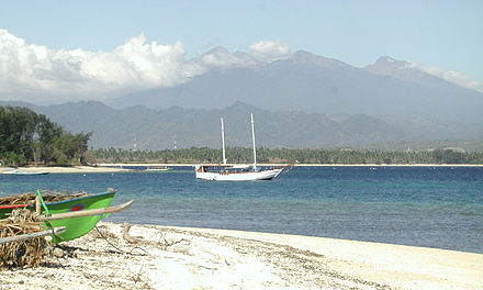
The lower and mid levels of the mountain are quite heavily forested. Above the tree line though the slopes are barren and rugged scree slopes and volcanic rock. The views of the crater lake are quite breath-taking from the caldera rim, as is the sunrise. From the absolute peak you can see Bali to the west and Sumbawa to the east.
Flora and fauna
The lower and middle elevation slopes are densely forested with typical tropical species. Fig trees are especially apparent. Casuarina forest (cemara) takes over higher up and eventually these give way to an alpine flora above the treeline.
Lombok is east of the Wallacean Line and some Australia bird species are therefore apparent. These include a lot of sulphur crested cockatoos and green hanging parrots. Bird life is generally not easy to observe here though due to the density of the forest.
The familiar long-tailed grey macaque (the Bali temple monkey) is common right up to the crater rim. Also the rare ebony leaf monkey inhabit these forests. Rusa deer and muntjacs are more often heard than seen.
Climate
Rinjani is best climbed during the April–November dry season. It is possible to climb during the rainy season as well but treks are often cancelled at short notice if the rain is heavy.
It gets cool indeed on the mountain above 2,000 m and nears freezing at the summit. Warm clothing is an absolute must.
Get in
Most visitors arrive via the village of Senaru (600 m), on the northern side of the mountain and thus closer to the main resort areas of the west coast including Senggigi. The other possible entry point is Sembalun Lawang (1,150 m), on the eastern side, which is closer to the summit. Porters are available in Sembalun. They carry 15-20 kg per porter, charging domestic tourists Rp 200,000/day, though foreign tourists pay more. Porters hike faster than the tourists and wait for them to catch up at a pre-arranged meeting place.
- Arfatourindo Transport, arfatourindo@gmail.com. Serves transports to Senaru or Sembalun Lawang from which you can do trekking. It can drive you from any places in Lombok. The owner is knowledgeable for Lombok island and speaks English and German. 2018-03-10
Fees and permits
Entry to the park costs Rp 150,000 per person. This fee is split up as follows: 13% to the national park authority, 62% to the Rinjani ecotourism trekking program and 25% for trek route maintenance etc. An online system has been implemented for permits and registration, with payments done through banks. Permits will be given only for a maximum of 200 climbers per day. Purchase your permit far in advance of your planned arrival time.
Get around
Within the park the only way to get around is to hike. Porters can be arranged to carry your supplies. Officially you're not allowed to trek up the mountain alone, but it can still be done with some paperwork, see the do section for this.
See
- Segara Anak. The crater lake of Mount Rinjani. Segara Anak translates to "Child of the Sea", as the lake water has the same colour as the sea. The water is heated by the volcano keeping the temperature just above +22°C and releasing gas bubbles into the water. The lake used to be depicted on the Rp 10,000 banknote.
- Aik Kalak hot springs. Three hot springs, that are of spiritual significance. According to local belief, bathing in one of them will slow ageing and rejuvenate you — give it a try! Also, a mixture of their water and coconut oil is used as a traditional medicine against many diseases.
- The Mulang Pakelem. An annual Hindu event, held before the rainy season at the crater lake featuring hundreds of Hindu pilgrims in white clothing. The event is to celebrate the Balinese invasion of the island in the 18th century.
- Gua Susu (Susu Cave). One of the mountain's famous caves (the others are Gua Payung and Gua Manik), this one is filled with hot steam and a popular place for meditation.
- Sendanggile Waterfall. At the foot of Mount Rinjani, featuring great views. 2015-09-03
Do
Climbing Mount Rinjani
The basics
At 3,726 m, Rinjani is the second highest volcano in Indonesia after Sumatra's Gunung Kerinci. It is very climbable by visitors with a high level of physical fitness. Critical is to understand and respect this great mountain: visitors have died here through failing to follow sensible procedures and make all necessary preparations.
Few actually make the very strenuous effort required to reach the actual summit but instead stop at the crater rim (approx 2,700 m) where the views of the crater lake are mind blowing. To make the extra 1,000 m ascent to the very top requires a considerably higher level of fitness, not to mention strength of spirit and sense of adventure.
Typically, a trek to the crater rim involves two days and one night on the mountain. The longer ascent to the summit can be done with just one night's camping but is often part of a longer trek of three to four days and two or three nights.


An organised trek is by far the easiest, safest and most popular option but it is also quite possible to make all of your own arrangements and just hire a guide and equipment from one of the trekking centres on the mountain. Rinjani Park regulations stipulate the use of a certified guide so the people at the center at the start of the hike are not happy to let you climb Rinjani without. With a lot of patience and explanations you can sign a paper which says that you are responsible for yourself and not the organisation. You will still pay the entrance fee, but it is by far the cheapest option to walk by yourself.
The mountains Licensed Guide Association (HPI) issues certification to the Rinjani guides and porters but it should be understood that the certification standards and required training are no where near as rigorous as would be expected in many other countries. Serious accidents including fatalities do occur on Rinjani treks when led by these accredited guides.
Proper sturdy climbing or hiking boots are an absolute necessity as is a substantial waterproof, windproof jacket, and a head lamp. If you are going to the top, use of poles (walking sticks) for getting through the scree (loose rock) at the top are also highly recommended. By 2,000 m, you will feel like you are not in the tropics any more as rising wet, hot air loses its temperature and may fall as rain. If inappropriate clothing becomes wet, difficulties will set in as air temperatures towards the summit are as low as 4°C, often with a significant extra wind chill factor. You must prepare accordingly.
Guides and trekking providers
At times it seems that everyone in Lombok is a trekking guide for Mount Rinjani, especially on the main tourist strip in Senggigi.
Take most of what you are told with a pinch of salt and you will find the most experienced and reputable guides at the main trekking centres at Senaru and Sembalun Lawang. It does happen that tourists who are highly experienced hikers or climbers may find themselves far better prepared and skilled for mountain conditions than the local guides. Codes of conduct have been developed for the local trekking support community that include climbing safety, environmental awareness and responsible use. Some of the guides and trekking organisations are better than others at respecting these agreements and guidelines. It is also a good idea to check independently for any volcanic alerts that may have been issued for Mount Rinjani.
Many visitors have found it is preferable to avoid package deals purchased away from Senaru, and instead negotiate either with one of the four trekking providers listed below or with the guides themselves to ensure that they are competent. If there is a problem, you can then find a different guide company in Senaru or Sembalun.
To help you judge the experience, abilities and equipment provision of a potential guide and support team it may assist to consider the following:
Use of booking services for Rinjani treks
The use of booking services and travel agents for the booking and pre-payment of Mount Rinjani treks should be approached with considerable caution.
One active booking agent uses names and logos that mimic established and legitimate providers and utilises multiple misleading and deceptive websites to redirect bookings and pre-payments to their own booking services.
The inadvertent use of an unscrupulous booking service may lead to your booking and any pre-payments being redirected to an alternative provider. This may result in the non-fulfilment of arrangements for pre-booked accommodation, transfers and mountain treks.
It is recommended to either use one of the providers listed in this article or to make arrangements directly with a provider after arriving in Lombok.
- preparation for rain squalls such as waterproof covers for equipment and supplies, personal raincoats or emergency ponchos
- ensure that all trek participants are provided with clothing suitable to the conditions and provided with a thermally protective layer such as polypropylene
- first aid equipment and training including treatment for exposure, provision of supplies such as emergency splints for fractures and space blankets
- provision of a trowel or fold-away shovel for burying human waste and the provision of toilet paper
- if the guide team are cooking or handling food are they going to wash and clean their hands, all plates and utensils using detergent or soap
- ensure that the guides and porters understand how to pitch their supplied tents and can demonstrate that the tents are complete and can be pitched using adequate pegs and with the fly sheets secured away from the tent so that moisture does not seep in even if it is windy and raining.
- provision of a route map detailing emergency assembly points and demonstrate a capacity to communicate a position to a rescue party
- that an emergency management plan is in place in case of accident or other emergency during the climb
- availability of a working mobile phone for emergency calls and provision of SIM cards that have sufficient credit to deal with communications in an emergency
- availability of a serviceable VHF hand held radio with two fully charged batteries and a capacity to use it in case of emergency.
- availability of a satellite phone in serviceable condition, in service, with active network reception and supplied with a fully charged battery
Guide fees are generally negotiable. Only the Rp 150,000/person/day park entrance fee is set by the park authority. A sensible package price range would be:
- 2-day, 1-night trek to the crater rim only: Rp 1,500,000-2,000,000 per person.
- 3-day, 1-night trek to summit, lake and hot springs: Rp 2,500,000-Rp 3,500,000
- 4-day, 3-night trek to summit,Lake&hot springs: Rp 3,500,000-4,000,000.
These trekking fees will vary though according to how busy the guides are, how many people are in your party and if a commission is due to a referring person or agency. Some guide companies will charge as little as Rp 900,000 per person for a 2-night trek in the off-season, but it is important to check they are properly experienced, equipped and provisioned. Ensure your trek price is all-inclusive of any extra charges for transportation, provisions, porter fees and the park entrance fees. The following all offer organised treks with accommodation, transport to the mountain, return to your accommodation and can also help with hiring a private guide if required:
- Dedy Adventure, sembalun village,East Lombok-Indonesia, +62340876767, info@rinjanitrip.com. Offer Rinjani Trekking package for beginner climbers and experienced climbers since 2008.
- Mr. Adi Rinjani, Senaru, Lombok, +62 852-3806-6401, mradirinjani@gmail.com. Adi is a guide himself and will help you organize and book your trip to Mount Rinjani. Besides all kinds of tracking packages, also transport and accommodation can be arranged. Treks can be booked as private tours or within a public but small group. Prices for 2019 can be seen on the website. Upon request, you will get a reply within 24 hours. 2019-07-07
- Dhyns Rinjani Hiking, Jalan Pariwisata Senaru, bayan, Nusa Tenggara Barat, +62 81238076623, dhynsrinjani@gmail.com. Offering tour packages to Mount Rinjani, from 2 days to 5 days program, and professional guide and porters.
- Full Rinjani, Jl Pariwiasta Senaru, Bayan, +62 87864356690, full123expedition@gmail.com. Offers a Rinjani trekking package. They tout their team as experienced, professional, friendly and caring about the environment and provide high-quality camping equipment (tents, sleeping bags, mattresses, pillows, camping chairs and a toilet tent) and tasty food.
- Hajar Trekking, Dusun Tumpang Sari Desa Senaru, Bayan, +62 81916014731, info@rinjanitrekkingplanner.com. Local trekking company in Senaru village concerning with an affordable trekking tour package service.
- Herman Trekker, Jalan Pariwisata, Senaru, +6281918429666, hermantrekkerrinjani@gmail.com. Headed by Herman, who used to work as a barman and is familiar with western culture and accommodation. Team of experienced guides for Mt. Rinjani. The team speaks good English and is polite and accommodating. Herman has a high respect for the environment and practices sustainable trekking activities. 2015-06-05
- John’s Adventures, Jl Senaru, Senaru, +62 817 5788018, rinjani_master@yahoo.com. Established agency with full range of trekking packages. John has been guiding climbers and arranging treks up Rinjani for over 20 years. Comfortable base at Senaru with a cafe, pickups are available from hotels and the airport.
- Jou Trekking, Jl Pariwiasta senaru, Bayan, +6285338627708, joutrekking@gmail.com. Provides packages to mount Rinjani. Guide & porters and good quality of trekking equipment.
- Evsi Rinjani, Jl Pariwiasta, Senaru village, +6281915987599, infotrekrinjani@gmail.com. Provides trekking packages to Mount Rinjani can be sharing package (join group) and private trek tour.
- Lhuna Adventure, Jln Pariwiasta Senaru Bayan, +6281339020882, info.adventure25@gmail.com. Rinjani trekking team . Touts its "great service" during the trek, transport and hotel.
- Lombok Rinjani Trek Organisation, Hotel Lombok Raya, Mataram, +62 370 641124, +62 813 53443445. Official partnership between the national park authority and local communities with support from NZ AID. Full range of trekking packages. City office in Mataram and one at each of the two trek departure points.
- Rinjani Footprint, Jl Wisata Alam Kerandangan, +62 813 5344 3445 (hotline), rinjani.fp@gmail.com. Professionally run expeditions under the management of an experienced operator.
- Rinjani Fun Trekking, Jl Pariwiasta, Senaru village, +6281999195335, rinjanifun@gmail.com. Reliable Mount Rinjani trekking organizer.
- Rinjani Trekking Club, Jl. Raya Senggigi Km 08, Senggigi, +62 370 693202 whatsApp +62 817 5730415, rinjaniclub@gmail.com. 24hr. Responsible, knowledgeable and run by Ronie. There is wide choice of guided hikes available; all include entrance fees, three meals a day, camping equipment.
- Trekking Mount Rinjani Organizer, Jalan cendrawasih No 8 Cakranegara, Nusa Tenggara Barat, +62 817 369010, info@trekkingrinjani.com. Tour packages offering the ascent of Mount Rinjani.
- Rinjani Samalas Tour & Trekking, Senaru village, +6282341446551, mailto:rinjanisamalas@gmail.com. Mount Rinjani hiking guide 2022-10-10
Ascent routes
Serious trekkers should explore the options of staying on the mountain for 3 nights or more with a planned trek that takes in the crater rim, down to the lake shore, the absolute summit and more. Such treks normally start in either Senaru or Sambulan Lawang however in the last couple of years some other routes have opened including the Benang Stokel, Timbanuh and Torean routes.
The Senaru ascent route
 This is by far the most used route as it allows the (relatively) less strenuous trek to the crater rim only. You start at an elevation of 600 m in Senaru village, normally in the late morning or early afternoon and make the 6 hour ascent to the crater rim before dark. The route passes through POSII at 1,500 m, breaches the treeline at 2,000 m (POSIII) and then it is a bit of slog up gravel paths to the camp site just below the crater rim at 2,600 m. Wake before dawn to make the 20 to 30 minute final climb to the crater rim to enjoy sunrise and the iconic view across Segara Anak to Gunung Baru.
If that has not sapped all of your energy you can then make a very precarious descent down to shores of the crater lake and bath in the hot waters. You need some confidence to do this as it is a steep descent of over 600 m using handrails and ropes.
And then it is back to Senaru the way you came.
There is an option to go on to Plawangan II where you overnight again before making the ascent to the absolute summit. This is not especially recommended from the Senaru side though. If you want to get to the top, the climb to Plawangan II is best made from Sambulan Lawang.
The Sembalun Lawang ascent route
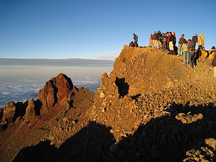 Starting in the morning from the Rinjani Trek Centre in the village, the climb to Plawangan II at 2,638 m will take about 8 hr via POSI (1,300 m), POSII (1,500 m) and POSIII (1,800 m). Overnight at the campsite here and go for the summit starting at 3AM the next day. You need to be well rested as this is a stiff task - the final climb is nearly 1,100 m on difficult ground.
The Benang Stokel route
Departs from the village of Aik Berik in Central Lombok and is about 27km east of Mataram or a little less than an hour’s drive. Locally Benang Stokel is well known for its 2 waterfalls, the Benang Kelambu waterfall and Benang Stokel waterfall. Treks normally depart from this waterfall location. The ascent up to the crater rim takes around 6 hours. From there a descent to the crater lake requires a further 3 hours. This track offers lots of variety and includes the Tiara Dewi Anjani waterfall. This is an route suitable for experienced trekkers.
Other activities
Guides for waterfall trips
Please use caution in accepting the services of some of the local guides. Payment fees to guide visitors to the first waterfalls may be demanded by local tout and guides. At times these activities can be quite aggressive and demanding. This behavior is most certainly not officially sanctioned and a guide is not required to visit the primary waterfall site.
You do not have to climb to the summit of Mount Rinjani to enjoy the splendors of the national park. Indeed unless you really think that you are physically capable it would be foolhardy to even try. You will find plenty of guides in either Senaru or Sembalun Lawang to suggest lower level treks through beautiful valleys.
- At Sembalun Lawang, there are several popular walks which will take you into remote villages famous for weaving. The Rinjani Information Centre in the main village will be able to help you with these.
- At Senaru take your time to explore the local villages. There are several nice waterfalls in this area all of which are reached via fairly gentle hikes.
Access to the primary waterfall is by way of an established pathway and steps. The fixed price entrance fee is posted at the ticket booth at the top of the steps leading down to the waterfall site.
A reputable and suitably experienced guide is recommended to walk to the second waterfall and is essential for the third which has a requirement for suitable climbing skills and equipment.
Many of the individuals that lurk near the entrance above the steps to waterfall site and nearby are opportunists with little or no guiding skills. These self proclaimed guides and their associates often demand a guide payment from visitors or guides who take people into Senaru from other areas such as Senggigi or the Tanjung area. If unsuccessful in gaining direct payment from a visitor they often demand it of the driver or guide who brought the visitor to the site. The extraction of this payment may be done in a manner that is not immediately apparent to the visitor. Some of the accompanying guides and drivers may explain this to the visitor, others may not. If a serious dispute develops with the local self proclaimed guides then explain to them that you will leave the site and travel to an alternative location.
There are other activities centred around the park including eco-walks and tree planting treks.
A day trip around the Senaru and Bayan region can provide a mix of nature and culture. Some providers can organise visits to the traditional village in Senaru, a walk through the rice paddies, and a short walk to the two waterfalls of Senaru with a refreshing dousing in the falling water at the bottom. It's also possible to visit the old mosque in Bayan, or to have a look at the production of handicrafts in and around Bayan. The food market in Ancak might appeal to some people who would like to try some typical local food.<br> All those things may be done independently, or with a guide from one of the trekking providers. This can offer some good alternative activities for those who are unable to make an ascent for any reason, including the standard seasonal closure of the ascent routes.
Choose the provider for a mountain ascent carefully to ensure they do actually have an understanding of the local environment and an informed and genuine commitment to environmental sustainability practice. One long term Rinjani trek provider, Rinjani Trekking Club, has attempted to shift the focus of activities upon the mountain to one of environmental respect and sustainability. Programs such as carrying out rubbish and maintaining clean camp sites and trails is a stated objective of the more eco-sustainable trek providers.
It is important to ensure that if a trek marketed as eco-friendly is taken that the trekking guides do indeed thoroughly conform to their own stated objectives and policies during the trek.
Eat
If you are trekking outside of an organised group, you should carry in all necessary food for your trek. Fresh fruit and high energy foods are especially appropriate. If you are planning to make the ascent to the absolute summit try to carry a special food item with you for celebrating your achievement of reaching the top. If you don't bring food and drink with you, be prepared to pay 5 times the normal price to vendors.
Trekking packages usually include food which is carried and prepared by the porters.
There are simple restaurants at the lodges in Senaru and Sembalun Lawang.
Drink
If you are trekking independently, stock up with some liquids at Senaru or Sembalun Lawang. A flask of hot tea or coffee is very appropriate.
There are a lot of fresh springs on both routes and these determine the positioning of the campsites. You therefore do not need to carry large quantities of water with you. The springs can run a little dry sometimes but all guides should know the status of each spring beforehand.
Sleep
Lodging
There is no lodging in the park itself, but some simple places to stay can be found at Senaru & Sembalun Lawang.
Tanjung on the nearby northwest coast has several more upmarket offerings, and both it and the Gili Islands are reasonably close to Mount Rinjani. Many visitors choose to stay in the Senggigi region and travel north to Mount Rinjani by road.
Accommodation for the Senaru route
Please see the sleep section at Senaru for details
Accommodation for the Sembalun Lawang route
- Lembah Rinjani Homestay, Sembalun Lawang village, +62 852 39841709, lembahrinjani@gmail.com. 10 double rooms all with cold water showers. Has a decent restaurant attached. Rp 175,000
Camping
Camping is possible at designated rest shelter areas on the ascent routes, and at the crater rim.
Stay safe
See also: Volcanoes#Stay safe
This is a very active volcano. Always be aware of the current assessment of eruptive activity. Sources worth keeping an eye on include local media and The Smithsonian Institute's weekly Volcanic Activity Report (dead link: February 2023). Do not take the word of a trek organiser as gospel on safety issues.
It is recommended that you come to Senaru the day before you begin trekking Rinjani , so you can have a proper rest and so you don’t need to wake up very early to get started. Most guides offer free accommodation in a local hotel for the night before the trek, plus you can get a light breakfast in the next morning – also included for free.
Rinjani is high enough that altitude sickness is a concern. Be aware of the symptoms and treatment.
It is also very cold up on the summit (4–5°C), so warm, windproof clothes are a must as are appropriate hiking boots and a head lamp. The sun can be very strong during the day and severe sunburn is a risk — you're on a high mountain and just a few degrees south of the Equator.
Make sure that your guide is carrying a radio with him and that it is fully charged and working. A test call to the trek centre is advisable. The trek centre has a satellite telephone and it can be used by visitors – ask to see the chart of charges.
Go next
- Back to Senggigi, Tanjung or Kuta for some well earned rest on the beach.
- Cross to the Gili Islands for a chill out and views of the huge mountain you just climbed.
East Lombok
2nd-order administrative division
West Nusa Tenggara
Primary administrative division