Saint-Tite - town in Mauricie, Quebec, Canada
 Sainte-Tite is a town in the Middle-Mauricie at the southeastern limit of the Laurentian shield, on the north shore of the St. Lawrence River, in the regional county municipality of Mékinac.
Today its economy is based on recreational tourism activities (Western festival, vacation, camping, hunting and fishing, mountain biking, snowmobiles, boating, flora and fauna observations), forestry, agriculture, several paragovernmental services (primary and secondary education, CLSD, municipality, etc.). Throughout its history, the leather industry has greatly contributed to the local economy; this industrial expertise served as the basis in 1967 for the Festival Western de Saint-Tite.
Understand
Geography
Saint-Tite has a territory of where 3673 inhabitants reside (2016). The village of Sainte-Tite is located at the junction of roads 153 (connecting Grand-Mère to Lac-aux-Sables) and 159 (connecting Saint-Roch-de-Mékinac to Sainte-Anne-de-la-Pérade).
Saint-Tite is entirely part of the Batiscania (hydrographic basin). The Laurentian Mountains are located to the northwest. In addition to the territory of the town of Saint-Tite and the resort hamlets (e.g. Lac Perchaude, Lac Trottier, Lac Pierre-Paul, Petite rivière Mékinac), the rest of the territory of this locality consists of agricultural land, sometimes hilly.
The Rivière des Envies has its source at Lac de la Traverse and is the most important hydrographic basin. Its course crosses rang Saint-Joseph to the southwest to the limit of Saint-Tite; then, its course crosses this last municipality subsequently, Saint-Séverin and Saint-Stanislas. It flows onto the west bank of the Batiscan River in Saint-Stanislas.
The "Rivière Mékinac du Sud" (South Mékinac River) flows over 17.8 km in Grandes-Piles, Hérouxville and Saint-Tite. It flows into the rivière Mékinac du Nord at Saint-Tite.
The Mékinac du Nord river flows from north to south over 17 km in Saint-Roch-de-Mékinac, Grandes-Piles and Saint-Tite, in particular by crossing Roberge Lake. It flows into the rivière des Envies in Saint-Tite.
The Pierre-Paul River with its 14 km course has its source at Lac Pierre-Paul in Saint-Tite. Its course describes a large Z by crossing a mainly agricultural territory (a forest part at the beginning of the route) successively Saint-Tite, Sainte-Thècle and Saint-Adelphe. In Sainte-Thècle, its course crosses the Saint-Thomas and Saint-Georges ranges. It flows into the Batiscan river near the village of Saint-Adelphe.
History
Indigenous families settled around Kapibouska Lake, undoubtedly formed by beaver dams erected south of the present village. The Indigenous people left artefacts of their passage, however, no writing or remains of buildings.
The first pioneer François D'Assise Cossette and his wife Marguerite Rivard settled in 1833 on the shores of Lake Kapibouska. In 1835, other settlers joined this pioneer family. In 1851, the Mission of Saint-Juste-de-Kapibouska was created around Lake Kapibouska. In 1859, the canonical erection was promulgated and the civil erection in 1863. The construction of the Grand Trunk railway took place from 1880 to 1884 in order to access the Piles railway. Four years later, the railway line was extended to Rivière-à-Pierre. In 1910, the territory of the city was detached from the parish. In 1998, the city and the parish merged to become the new City of Saint-Tite.
Get in
By car
- From Montreal (190 km. Time: 2 hr 34 min. Take highway 40 eastbound, to Trois-Rivières; Highway 55 North, to Saint-Maurice River Highway 153 North to the village of Saint-Tite.
- From Quebec City. (129 km. Time: 1 hr 39 min. Take highway 40 west to Sainte-Anne-de-la-Pérade, then take route 159 through the villages of Saint-Prosper-de-Champlain, Saint-Stanislas and Saint-Séverin, to the village of Saint-Tite.
;Trails The Quad trail (dead link: January 2023) passes through the forest north of Saint-Tite.
Get around
Gas stations
- Garage RG Davidson, 995, route 153, 46.74083°, -72.55847°, +1 418-365-5038. 2021-10-26
- Station-service Sonic, 480, boul. Royal, 46.72605°, -72.56886°, +1 418-365-3221. 2021-10-26
- Station-service Shell, 655, rue le Bourdais, 46.73182°, -72.57160°, +1 418-365-1413. 2021-10-26
- Station-service Ultramar, 995, route 153, 46.72973°, -72.57450°, +1 418-365-5038. 2021-10-26
- Harnois Groupe pétrolier, 669, route 153, 46.73152°, -72.57271°, +1 418-365-5038. Specialized for trucks. 2021-10-26
Charging stations
Municipal terminals for electric vehicles:
- Métro Saint-Tite, 621, route 153, 46.72967°, -72.57461°. 2021-10-26
- Sportium municipal (aréna), 425, boulevard St-Joseph, 46.73089°, -72.56055°. 2021-10-26
- Stationnement municipal (du Moulin) (Municipal parking (du Moulin)), 445, rue du Moulin, 46.72938°, -72.56499°. 2021-10-26
- Stationnement bureaux MRC de Mékinac (MRC de Mékinac office parking), 560, rue Notre-Dame, 46.72682°, -72.56451°. 2021-10-26
Railway station
- Gare ferroviaire de VIA Rail (VIA Rail train station), 560, rue Notre-Dame, 46.72313°, -72.56416°. 2021-10-26
See
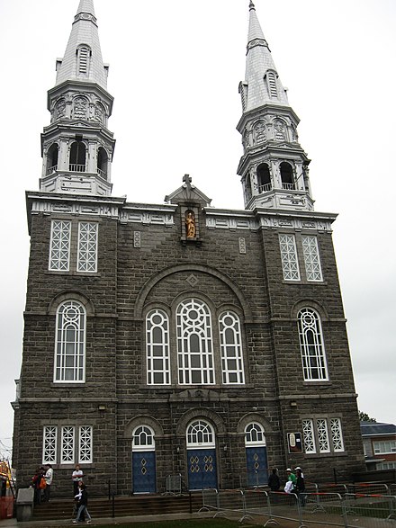
- Église catholique de Saint-Tite (Church of Saint-Tite), 531, rue Notre-Dame, 46.72804°, -72.56398°, +1 418-365-6594. 2021-10-20
- Presbytère de Saint-Tite (Presbytery of Saint-Tite), 531, rue Notre-Dame, 46.72788°, -72.56391°, +1 418-365-6594. 2021-10-20
- Cimetière de Saint-Tite (Saint-Tite cemetery), boul. St-Joseph, 46.73045°, -72.56007°, +1 418-365-6594. 2021-10-20
- Musée Souvenirs d'autrefois (Souvenirs from the past), 240, route 159 (chemin Haut du Lac Sud), 46.7318°, -72.6116°, +1 418-365-6728, + 1 418-365-7342, Robert-mado@hotmail.com. In the middle of 20th century, the highest concentration of citizens of Saint-Tite lived here. The museum was built to pay homage to the ancestors of the Mauricie region. It houses in well-reconstructed decorations: a kitchen, a bedroom, a chapel and a barn. 2021-10-20
Do
- Club de tir Saint-Tite (Saint-Tite Shooting Club), 333, route 153, 46.71104°, -72.59078°. 2021-10-27
- Club des Ainés de Saint-Tite (Saint-Tite Seniors Club), 480, boulevard St-Joseph, 46.72996°, -72.56112°, +1 418-365-7368. Reception room, with kitchen, in the heart of the village of Saint-Tite. 2021-10-27
- Club de ski de fond Le Sillon (Le Sillon cross-country ski club), 1670, chemin du Lac Pierre-Paul, 46.73890°, -72.49825°, +1 418-365-6967. Cross-country ski centre in the heart of nature. Four cross-country ski trails (11.2 km) and seven snowshoe trails (11.2 km). Equipment loan. 2021-10-27
- Conscience Nature, 1650, Grand Rang, 46.68956°, -72.53437°, +1 581-777-4360, consciencenature@hotmail.com. Guide, hike and mushroom picking. 2021-10-27
- Miniferme du Boisé, 220, chemin haut du lac Sud, 46.73077°, -72.61516°, +1 418-365-2266, minifermeduboise@hotmail.ca. Mini-farm on the west side of the village of Saint-Tite and open year round. Guided tour of the mini-farm on more than , lasting 2 hours. by reservation: more than 400 animals, 28 different species, such as horses, cows, alpacas, llamas, goats, sheep, donkeys, rabbits as well that several birds such as emu, peacocks, pheasants. Clientele: families, school groups, day camps and birthday parties; visitors can have a family picnic there. On the tour, visitors get to know the animals and their history, can pet and feed them. The mini-farm is a partner of the Galahad et Térégo animal refuge. Visitors can also admire the reproduction of a village in the Old West. 2021-10-27
- Pisciculture les truites de la Mauricie (Mauricie trout fish farming), 1321, route 153, 46.75725°, -72.54020°, +1 418-365-3352. Pond fishing. 2021-10-27
- Salle des Chevaliers de Colomb (Knights of Columbus Hall), 700, rue Brunelle, 46.73112°, -72.55938°, +1 418-365-7163. Meeting and reception room. 2021-10-27
Heritage tours
- Saint-Tite historical route (Saint-Tite historical route), rue Notre-Dame, 46.71104°, -72.59078°, +1 418-365-5143 ext 161, loisirs@villest-tite.com. 15 historical interpretation panels. 2021-10-27
- Balado Western: Histoires de cowboy (Western Podcast: Cowboy Stories), Saint-Tite, 46.72688°, -72.56441°. About ten audio clips on the western world of Mauricie were produced jointly by Tourisme Shawinigan, the MRC de Mékinac and the MRC des Chenaux. These "Cowboy Stories" capsules tell the story of a cowboy's tour who introduces you to western culture on a daily basis through a series of businesses in the Mauricie region. Westerners are invited to stroll through three MRCs in the Mauricie region: Shawinigan, Mékinac and des Chenaux, while listening to these Western capsules. Available on the baladowestern.com site, the route map includes the location of the Balado Western posters with QR codes allowing you to listen to the capsules, and to discover the people who built the region and the world of the Mauritian western. 2021-10-27
Scenic routes
- Panoramic route Saint-Tite-Saint-Roch-de-Mékinac. 14 min, over 19 km between Saint-Tite and Saint-Roch-de-Mékinac. From the intersection of route 153 and 159, west of the village of Saint-Tite, take Chemin du Haut du Lac Sud (north-west). Visitors then walk along the meandering part of the Rivière des Envies, that is to say the old Kapibouska lake which flooded this area because of beaver dams, until the end of the 19th century. Visitors can make a stop (by appointment at +1 418-365-6728) at the Musée Souvenirs d'autrefois, 240, route 159 (Haut du Lac Sud), Saint-Tite. Then the road spans the Mékinac du Sud River (starting at Tavibois, Hérouxville), then the Mékinac du Nord river. After the agricultural zone, the resort has developed along the Mékinac du Nord river which originates at Lake Roberge, in the municipality of Grandes-Piles. On Chemin Petite Mékinac, visitors then walk along the magnificent Lac Roberge, whose mountains opposite reach 417 m. This lake receives the Castor river (coming from Saint-Thècle) and the discharge of the second Roberge lake. The mountainous and forest scenery of this wild and encaved valley is splendid, particularly in the season of colorful trees. Visitors then cross the intersection of Chemin du lac Fontaine (resort lake); this road joins Chemin Joseph St-Amand in Sainte-Thècle and Lac du Jésuite (resort lake). Opposite this intersection, it is the start of Chemin du lac des îles and very close to Chemin du Lac Clair. The national trail arrives in this area at Route 159. Continuing on Route 159, visitors enter Saint-Roch-de-Mékinac and follow Second Lac Roberge and Lac Méduse. Finally, visitors arrive at the village of Saint-Roch-de-Mékinac which was rebuilt on the promontory after the construction of the Grand-Mère dam which flooded the site of the old village. Visitors can return via Grandes-Piles and admire the panorama of the valley of the Saint-Maurice river. Free 2021-10-18
Events
- Festival Western de Saint-Tite (Saint-Tite Western Festival), (administration) 581, rue St-Paul Bureau 107, 46.72917°, -72.56168°, +1 418 365-7524, info@festivalwestern.com. Festivities over ten days, from the 2nd to the 3rd weekend in September. The most important western festival in Eastern Canada. Great shows and equestrian competitions. The 53rd edition took place in September 2021. 2021-10-29
Buy
;Food/alcohol
- Boucherie Veillette Albert & Fils (Butcher Veillette Albert & Fils), 302, rue St-Paul, 46.72681°, -72.56624°, +1 418-365-6131. Butcher famous for steak in Veillette. 2021-10-27
- Épicerie Métro Saint-Tite (Saint-Tite metro grocery store), 621, route 153, 46.72968°, -72.57461°, +1 418-365-6115. General grocery store. Prepared meals and cold and hot buffet. 2021-10-27
- SAQ Saint-Tite, 512, rue du Moulin, 46.72773°, -72.56493°, +1 418-365-6137. Service counter of the Société des Alcools du Québec (SAQ). 2021-10-27
;Western articles store
- Bottes Boulet (Boulet Boots), 501, rue St-Gabriel, 46.72588°, -72.56223°, +1 418-365-5174. Shoe shop. 2021-10-27
- Boutique équestre Saint-Tite (Equestrian shop Saint-Tite), 31, rue Notre-Dame, 46.73368°, -72.56755°, +1 418-365-5233, boutiquebest@hotmail.com. Custodian of the products of the manufacturers: Boulet, Wrangler, Outback, Roper. 2021-10-27
- Boutique souvenir du Festival Western, 454, boul. St-Joseph, 46.73027°, -72.56120°, +1 418-365-7524, info@festivalwestern.com. 2021-10-27
- Village Western Kapibouska, 661, rue Notre-Dame, 46.72565°, -72.56325°, +1 418-365-4370. The seasonal summer public market. Local products: agrifood, artisan products, general store. Late June to late September. 2021-10-27
;Others
- Désaulniers Bicycles, 235, rue Notre-Dame, 46.73079°, -72.56617°, +1 418-365-5854. Sale and repair of bicycles. 2021-10-27
- J.M. Sports inc, 890, route 153, 46.73732°, -72.56183°, +1 418-365-6370, danny@jmsports.ca. Arctic Cat, ATV and snowmobile dealer, Club Cadet, Stihl, Ezgo, Sledez, Husqvarna and Ariens. Sale and repair, as well as accessories and clothing for these types of sports. Seasonal storage service for snow blowers, ATVs and snowmobiles. Chainsaw, generator and snowmobile rental service. 2021-10-27
- Maison M. Bussière, 421, rue Notre-Dame, 46.72887°, -72.56549°, +1 418-365-6155, maisonmbussiere@globetrotter.ca. Operating under the Chaussure Pop banner. Footwear for all family needs, training and outdoor clothing, work boots, water boots, cowboy boots, handbags, accessories, shoe cosmetics as well as a cleaning service, sharpening of personalized skates and soles. 2021-10-27
- Un Brin de Laine Plus (A Strand of Wool More), 302, rue St-Paul, 46.72679°, -72.56634°, +1 418-365-3936. Art and craft shop specializing in painting, stained glass and embroidery materials. 2021-10-27
- Rose Pétale (Rose Petal), 100, rue du Moulin, 46.72600°, -72.57024°, +1 418-365-5053, fleuristerosepetale@gmail.com. Floristry and gift shop offering flower arrangements for all occasions. 2021-10-27
Eat
Budget
- Casse-Croute Aux Petits Bonheurs, 411, rue du Couvent, 46.72719°, -72.56377°, +1 418-365-4575. 2021-10-08
- Casse-Croûte Rouli-Roulant, 439, route 153, 46.72450°, -72.57352°, +1 418-365-6033. Snack bar at the southern entrance to the village. Seasonal restaurant. 2021-10-08
- Restaurant Casse-croute Au Pignon bleu, 41, boul. St-Joseph, 46.73506°, -72.56442°, +1 418-365-7090. 2021-10-08
- Restaurant Casse-Croûte, 439, route 153, 46.72442°, -72.57360°, +1 418-365-6033. 2021-10-08
- Café Papillon, 350, rue Notre-Dame, 46.72980°, -72.56626°, +1 418-365-5970. 2021-10-08
Mid-range
- Bistro La Vieille Banque, 441, rue Notre-Dame, 46.72858°, -72.56535°, +1 418-365-4191. Bistro in the heart of the village. Style inspired by the old safe still present in the establishment. Healthy menu, no frying. 2021-10-08
- Brasserie 500 Steakhouse, 765, route 153, 46.73484°, -72.56648°, +1 418-365-5077, administration@brasserie500.com. Catering service for snowmobile, ATV, motorcycle and horse riding activities. 2021-10-08
- Brûlerie Mékinoise, 670, rue Notre-Dame, 46.72548°, -72.56362°, +1 418-507-3489. Micro burner, tea. 2021-10-08
- Pizzeria Stratos, 440, rue St-Gabriel, 46.72492°, -72.56306°, +1 418-365-6666. Meals on site. Take-out orders. Delivery. 2021-10-08
- Restaurant Chez Ti-Poil, 390, route 153, 46.72281°, -72.57479°, +1 418-365-6680. Specialties: pizzas and brochettes, lunches and table d'hôte. 2021-10-08
- Terrasse du Festival Western (Western Festival terrace), 510, rue du Moulin, 46.73022°, -72.56355°, +1 819-692-9250. 2021-10-08
Drink
- Bar le Reflet, 261, rue du Moulin, 46.72776°, -72.56802°, +1 418-365-4370, gestionaded@hotmail.com. Resto-bar. Meals on site. Orders to bring. Specialty: chicken wings, burger. 2021-10-27
- Microbrasserie À la Fût - Resto-Publ-Saloon (On-tap microbrewery - Resto-Publ-Saloon), 670, rue Notre-Dame, 46.72549°, -72.56359°, +1 819-523-7711, info@alafut.qc.ca. Resto-Pub-Saloon since 2007 to discover craft beers. Meal service. Twenty barrel lines in continuous operation. This business is established in the first general store in the western village of Saint-Tite. 2021-10-27
Sleep
Camping
- Au Camping Le Rocher, 891, boulevard St-Joseph, 46.72462°, -72.55684°, +1 418-365-3315. Campsite near the village of Saint-Tite. 2021-10-27
- Camping Marchand, 170, rue Notre-Dame, 46.73170°, -72.56696°, +1 418-365-3315. Campsite in the village. 2021-10-27
- Camping Écurie (Camping Stable), rue du Couvent, 46.730002°, -72.55627°, +1 418-365-3315. Camper stable used for the Festival Western. 2021-10-27
- Camping La Gervaisie, 1 chemin du lac Trottier, 46.77100°, -72.55309°, +1 418-365-7171. Family campsite near Lake Trottier in Saint-Tite. Swimming pool, kayak, children's play areas. Rental of trailers. 2021-10-27
- Camping Trépanier, 605, route 153, 46.72817°, -72.57466°, +1 418-365-7171. Campsite in the village. 2021-10-27
Chalet, gîte, inn
- Auberge Kapibouska (Kapibouska Hostel), 661, rue Notre-Dame, 46.72569°, -72.56323°, +1 418-365-8005. Private rooms in a townhouse, in the heart of the village. 2021-10-27
- Gîte de l'Artiste, 1021, Grand Rang, 46.71799°, -72.55532°, +1 418-365-3855, pierre_patry@cgocable.ca. A gite in an ancestral house in the countryside, featuring a distinctive art gallery, surrounded by gardens and a swimming pool. 2021-10-27
- La vieille Maison Rouge, 261, rue Notre-Dame, 46.73042°, -72.56616°, +1 418-365-6411, vieillemaisonrouge@videotron.ca. Tourist lodging. 2021-10-27
- Le Gîte du Village, 460, rue Notre-Dame, 46.72834°, -72.56546°, +1 418-365-7668, giteduvillage@globetrotter.net. Gîte in an ancestral house in the heart of Saint-Tite. This cottage has five cozy bedrooms (king, queen or double) and four bathrooms. Full tasty breakfasts. Outdoor activities: cycling, cross-country skiing, mountain biking, snowshoeing. 2021-10-27
- Refuge des 3 P'Tits Cowboys, 70, chemin du Lac-Trottier, 46.76701°, -72.55323°, +1 450-756-8616. Refuge on the edge of Lake Trottier in Saint-Tite. Swimming and non-motorized water sports with its sandy bottom lake and crystal clear water. 2021-10-27
- Lac Perchaude (hotel pavillonnaire) (Lake Perchaude (suburban hotel)), chemin Allard, 46.75887°, -72.55763°. Suburban hotel. 2021-10-27
Cope
- Sportium municipal, 425, boul. St-Joseph, 46.73088°, -72.56064°, +1 418-365-5143. 2021-10-27
- Bibliothèque Marielle-Brouillette (Marielle-Brouillette Library), 330, rue du Moulin, 46.72793°, -72.56686°, +1 418-365-5143. Loans of books, audio books, magazines etc. The library accepts special requests through access to the Regional Center for Public Library Services. 2021-10-27
- Parc Adrien Bélisle (Adrien Bélisle Park), rue Adrien-Bélisle, 46.725218°, -72.566698°, +1 418-365-5143. Soccer field. Softball field with stands. Children's play area. 2021-10-27
- Piscine municipale (Public pool), rue Adrien-Bélisle, 46.72612°, -72.56609°, +1 418-365-5143. This public swimming pool is located in Parc Adrien-Bélisle. 2021-10-27
Ecocentre
- Écocentre de Saint-Tite (Saint-Tite Ecocentre), 1019, route 153, 46.74528°, -72.55310°. The Ecocentre operated by agreement under the aegis of Service Cité Propre Inc. 2021-10-27
Go next
Saint-Tite
villest-tite.comMauricie
2nd-order administrative division
Quebec
Primary administrative division