South Iceland - region of Iceland
South Iceland is the region of Iceland along the North Atlantic Ocean.
Towns
Towns are listed in an west-east order.
- Hveragerði - located in a geothermal area, less than an hour from Reykjavík by car.
- Eyrarbakki - beautiful old village on the south coast. Also worth visiting are nearby Stokkseyri and Þorlákshöfn.
- Selfoss - the largest town in the south.
- Stokkseyri
- Hella and Hvolsvöllur - two nearby villages in the agricultural heartland of western South Iceland.
- Vestmannaeyjar is the name for both a town and an archipelago just south of Iceland. The biggest and main island Heimaey is known for its 1973 volcanic eruption that destroyed part of the town, and for the Atlantic puffin colonies. Millions of birds spend summer and breed in the island's cliffs. It is possible to visit Heimaey as a day trip from Reykjavik.
- Vík - a coastal village world famous for its puffins, black sand beaches, impressive basalt columns and strange rock formations in the ocean.
- Kirkjubæjarklaustur - a village in the sparsely populated Skaftárhreppur, in the eastern part of South Iceland.
Other destinations

- Upcountry Árnessýsla - A rural area in the north-western corner of South Iceland. Home to some of the most famous tourist destinations in Iceland including Gullfoss and Geysir.
- Landmannalaugar - One of the great jewels of Iceland, located in the Southern Highlands is Landmannalaugar. The area's incredible natural beauty and extreme contrasts have been attracting visitors for centuries. It's a mountainous area rich in minerals, which results in strong colors, and its impressive volcanic geology brings you to massive, old lava fields and natural hot springs. There's a mountain hut operated by Ferðafélag Íslands, and a simple, rocky camp ground is there as well. There is a simple mountain shop/café where snacks and coffee can be bought, as well as fishing license to the nearby lakes, where you can catch mountain trout. There is also one horse rental operated by Hraunhestar, ranging from 2 to 10 hours in length through the spectacular valleys and many marked hiking trails, one leading all the way south to Þórsmörk.
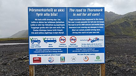
- Þórsmörk - A natural pearl situated in a valley, tucked in between two glaciers. There are many hiking opportunities in the area, with its large network of marked trails. There is a lovely camp ground and several mountain cabins and little bungalows. Road access is by F-roads only and requires a large 4x4 as there are a number of river crossings (see offroad driving).
Understand

The area is the setting of some of Iceland's most popular sagas and home to many of their heroes. Njáll's saga, one of the most famous sagas, is largely set in South Iceland with the title character Njáll living at Bergþórshvoll and the hero Gunnar hailing from Hlíðarendi in Fljótshlíð near Hvolsvöllur. These farms still exist today, but don't expect to see medieval ruins. Icelandic building materials were not made to last, and the farms you see today are twentieth century constructions. However, the nature and the scenery remain as impressive.
The region also contains two of the most important seats of power of medieval Iceland: Skálholt was the location of the bishop of Iceland from 1056 until 1106, when north Iceland received a bishop of its own but Skálholt remained the seat of a diocese covering east, south and west Iceland until 1801. Þingvellir was the meeting place of the Alþingi, the joint parliament and court founded in 930. Alþingi lost its legislative functions in 1662 but remained a court held at Þingvellir until 1800. Alþingi was revived in 1845 as advisory and later legislative assembly in Reykjavík. It was also at Þingvellir that, on 17 June 1944, Iceland was declared a republic.
The eastern part of South Iceland is dominated by the glacier Vatnajökull and the water systems linked to it. Big rivers flow from the glacier in all directions and have created large flood planes along the southern coast. The glacier and some of the surrounding areas form Vatnajökull National Park, the biggest national park in Iceland.
Unlike these rest of Iceland's coast, the south is not a fishing area because it has practically no natural harbours. The southern coastline from Þorlákshöfn in the west to Höfn in the east contains an almost unbroken sand beach open directly to the treacherous Atlantic Ocean.
Get in
By car
Taking the Ring road east from Reykjavík will very quickly lead you into South Iceland. This is how by far most locals will choose to travel and as with the rest of Iceland, having a car of your own will give you a lot more options for exploring the region than relying on public transport. When entering from Reykjavík, you also have the alternative of taking the road through Þingvellir to enter South Iceland. Drive up on the ring road through Mosfellsbær (a town on the outskirts of Reykjavík), as if you were heading for West Iceland, and following the signs indicating Þingvellir (road nr. 36).
If you're entering the country by ferry and bringing your own car, you will drive off the ferry in Seyðisfjörður in East Iceland. Once you get to the ring road, head southwards and you should be able to reach South Iceland in a few hours. It may be best, though, to stop somewhere around Höfn in the southeast before heading further, as the distances are big.
By plane
Mainland South Iceland is not served by any flights, domestic or international. On the western side, it's within reach of Reykjavík, which has a domestic airport that connects with some of the towns in different parts of the country. The eastern half of South Iceland can be reached by flying from Reykjavík to Höfn (a town in the southeast) with Eagle Air. This is close to Vatnajökull National Park, Jökulsárlón and other popular destinations.
Vestmannaeyjar has a domestic airport with flights from Reykjavík with Eagle Air.
By bus
Scheduled buses run along most of South Iceland operated by Sterna Travel. Reykjavík Excursions also has some scheduled services and a number of guided tours.
The Reykjavík area bus system (Strætó) reaches all the way to Selfoss. Take bus nr. 51 from Mjódd, which goes over Hellisheiði to the town of Hveragerði and then terminates in Selfoss.
Get around
By car
The south is well served by the ring road, which goes through the region from west to east serving most of the population centres on the way. The western part of the south is one of few regions in Iceland where populated areas are found far inland, and this area has a good road system as well. Further east the interior turns into highlands and glaciers, and should only be reached by 4x4s.
By bus
As in the rest of Iceland, public transport can be quite difficult to navigate and cannot take you everywhere. However the bus system is slightly more developed in the south and there is a bus that travels daily along the entire southern section of the ring road. There are also buses that travel between the upcountry towns in the western part of the south. Most of these are operated by Sterna Travel or Reykjavík Excursions, but it may also be worth it to ask around locally as there may be different seasonal options.
By boat
A ferry called Herjólfur, operated by Eimskip (dead link: December 2020), runs between the mainland and Vestmannaeyjar. A new harbour has been created in Landeyjar, shortening sailing times significantly, but as it frequently fills with sand the old harbour at Þorlákshöfn is also in use. Add to this the fact that high waves often occur on the route and you get very irregular travel times, so it's best to check the status of the ferry before showing up at the pier. If you're traveling by car, it can also be brought to the islands with the ferry.
See

- Þingvellir National Park - this is the most popular national park in Iceland and a UNESCO World Heritage site, approx. 40km east of Reykjavík. The valley is mentioned in many famous Icelandic sagas and is where one of the oldest parliamentary institutions of the world, the Althing, was founded in the year 930. Tectonic activity can be clearly seen here: the continental drift of North-American and European shelf plates has identified and scarred this area for thousands of years. The valley itself is the result of this activity and is getting wider every year. Free parking.
- Seljalandsfoss - one of South Iceland's many falls, falling off a 60 m high cliff. Its biggest attraction is the pathway leading to behind the falls. Access to the falls is free and open year round. There are no services at the falls, besides a picnic table and a public bathroom.
- Skógar - a small village home to the mighty and beautiful Skógafoss waterfall and one of Iceland's most famous museums, Skogar Folk Museum.
- Skógafoss is 60 m tall and 25 m wide and comes from the river of Skógá. The falls have been protected since 1987. Access to the falls is open all year round and there is no admission. A trail leads to the top of the falls (via metal stairs to the right of the waterfall) and up the Skógá river valley. This trail eventually ascends all the way to the Fimmvörðuháls pass between the Eyjafjallajökull and Mýrdalsjökull glaciers before descending to Þórsmörk; the complete hike from Skógar to Þórsmörk generally takes two days. Day hikers can follow this trail as far as they like along the Skógá river, they will be rewarded with views of more than a dozen waterfalls.
- Skogar Folk Museum houses a large collection of antique and historical artifacts. The museum is stretched over a large area, with 13 houses standing on the museum grounds. The museum is open June to August from 09:00 to 18:30, May and September from 10:00 to 17:00 and the rest of the year from 11:00 to 16:00. Entrance is 1,000 kr for adults, 600 kr for students, seniors and children aged 12-15. Free for children under 12 if accompanied by an adult. There are several services in town, including restaurants and accommodation.
- Kvernufoss is a waterfall nearby the more famous sibling, far less visited, but no less picturesque. Just 10 minutes from the car parking.
 Fjaðrárgljúfur Canyon 📍 is one of Iceland's most popular canyons, located near Kirkjubæjarklaustur.
- Skaftafell (formerly Skaftafell National Park) is a part of Vatnajökull National Park and contains the Skaftafellsjökull glacier and the Svartifoss waterfall.
- Jökulsárlón (Glacier Lagoon) is a glacial lake with ice bergs floating out to sea. Diamond Beach across the road is a well-known beach where pieces of ice glint in the sun like diamonds.

Itineraries
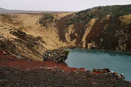
A Golden Circle tour generally includes – at a minimum – Geysir, Gullfoss, and Þingvellir. Various companies offer day coach tours, or a better alternative is to rent a car for a day; this will let you see many more sights and often save money, especially if you have two or more people in your group. This also lets you vary the time you want at each attraction, linger at the geysers, or have a stop at Kerið.
Do
- Fimmvörðuháls – a popular hiking trail, from Skógar to Þórsmörk, between Mýrdalsjökull and Eyjafjallajökull. Eyjafjallajökull famously erupted in 2010 sending an ash cloud across Europe, but shortly before that eruption Fimmvörðuháls itself erupted, causing the trail to be closed for a while. It is now completely safe again, and has the added attraction of seeing brand new landscapes.
- Laugavegur trail (or Laugavegurinn) – another popular hiking trail from Landmannalaugar to Þórsmörk, 55 km long, takes around 4 days, with huts and campsites on the way where you can stay overnight (Brennisteinsalda —Hrafntinnusker — Álftavatn or Hvanngil — Emstrur (Botnar) — Þórsmörk (Langidalur)). Caution: Could be dangerous during bad weather conditions: several people got lost or even died on the route. Each summer the trail is host to a cross-country marathon called the Laugavegur Ultra Marathon is held on the route. Don't confuse it with the shopping street of the same name in Reykjavík. It is possible is to do hike Laugavegurinn and Fimmvörðuháls together, as they both lead to Þórsmörk.

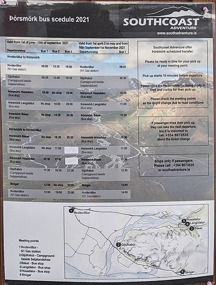
 Þórsmörk (or Thorsmörk) hiking trails. Highlands area with good public transport options. Buses depart from the parking lot at Seljalandsfoss waterfall. Southcoast Adventure also offers regular bus service from the campground next to Seljalandsfoss and from Hvolsvöllur. Self-driving is only possible with a larger 4x4 as there are a number of river crossings.
- River rafting is possible in both Hvítá and Markarfljót, close to Selfoss and Hvolsvöllur respectively.
- Glacier tours – traveling with specially equipped trucks onto Vatnajökull offers incredible views of the white desert that is Europe's largest glacier.
Eat
The western part of South Iceland is in many ways Iceland's agricultural heartland, and hosts many traditional Icelandic farms with sheep, cattle, horses and other animals. It's one of the main dairy producing regions of the country, producing most of the milk consumed in the capital region. Further east, aquaculture and fresh-water fishing plays an important role. Arctic char from Kirkjubæjarklaustur is known in Iceland as a delicacy. Also worth mentioning is the farm Þorvaldseyri , the only place where wheat is grown in Iceland. You can buy it direct from the farmer.
Awareness of the value of local produce is increasing, and farmers markets are becoming ever more common in South Iceland. You should also ask in restaurants whether they have some local specialties, chances are that they do.
Drink
There isn't much in the way of nightlife in South Iceland outside the main towns. Of the towns it should be no surprise that Selfoss, being the largest town in the region, has the most active nightlife.
South Iceland is home to one of Iceland's smaller breweries, called Ölvisholt Brugghús. It's located in a rural area about 10km outside Selfoss and their three main beers are called Skjálfti, Freyja and Móri.
Stay safe
The major concern for safety in South Iceland are the roads. The roads leading inland from Selfoss are very narrow and drivers should take special precaution. The national road from Reykjavík to Hveragerði, a mountain pass called Hellisheiði, can be particularly dangerous in winter, as blinding snow storms, icy roads and strong wind is common.
As the southern coast is open directly to the Atlantic Ocean, it's important to be very careful when on the beach. Appearances can be deceiving, and tides can be strong. Tourists have been killed when suddenly swept out to sea.
Go next
Continuing east out of South Iceland will bring you to East Iceland, with the stunning East Fjords. To the west is Southwest Iceland including the vibrant capital Reykjavík and the international airport in Keflavík. Alternatively you could choose to head towards the Interior, the expansive highland region which can only be accessed in 4x4s but offers some incredible rugged landscapes. You could cross via Kjölur or Sprengisandsleið and reach North Iceland on the other side of the island, but for this you need to be very well equipped and do good research on both road conditions and weather before setting off.
