The North Cascade Loop
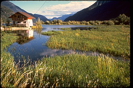
The North Cascades Loop is a beautiful 440-mile driving itinerary in the North Cascades of Washington. It is a very diverse drive, encompassing pristine mountains, grand rivers, picturesque islands, and rolling river valleys.
Understand
This loop passes through some of the most spectacular and diverse scenery in northwestern Washington around and in the North Cascades Mountains, crossing the mountain range itself twice and also going through bucolic Whidbey Island, beautiful Lake Chelan, and peaceful river valleys. All roads on this route are paved and well-maintained, but the North Cascades Hwy. is closed in winter, making this loop only passable during the summer months. To complete the loop, you also need to take a Washington State Ferry from Mukilteo to Whidbey Island (Clinton).
Prepare
While doing a day-trip on this loop is theoretically possible, it would not be a good idea because you would have no time at all to stop and enjoy the scenery. Two days is probably the bare minimum, but three to four days would allow you to explore this loop in much better detail. Driving is the only way to experience this loop.
Get in
By plane
The closest major airports to the route are Seattle-Tacoma International Airport, which is about 45 minutes south of Everett on the loop, and Vancouver International Airport which is about one hour and fifteen minutes from Burlington (in the Skagit Valley, also along the North Cascade Loop). Bellingham and Everett have airports that service to other cities in the western states, such as Las Vegas, Los Angeles, Palm Springs, Phoenix, San Diego, San Francisco Bay Area (such as Oakland or San Francisco). Wenatchee has three flights from Seattle-Tacoma, but unless you take this connecting flight during the morning or evening commute it's unlikely to be worth it.
By car
From Seattle or Portland, take I-5 north to Everett, and begin the loop from there. From Vancouver (BC), take BC-99 and I-5 south to Burlington, which is on the route. From points on the east, including Spokane, take US-2 or I-90 and US-97 to join the loop at Wenatchee or Leavenworth.
By train
Amtrak Cascades serves Everett and Mount Vernon. Amtrak's Empire Builder serves Wenatchee, Leavenworth and Everett. The loop can be started at any of those cities.
Drive
For our purposes, the city of Everett will be our starting point and the description of the loop will go clockwise from there, even though you can start anywhere , such as Burlington, Wenatchee, etc. and go either direction. The loop has been divided into eight main sections.
Whidbey and Fidalgo Islands
From Everett, drive west on WA-526 to Mukilteo, and catch the ferry across Possession sound to Whidbey Island (Clinton 📍). Whidbey Island is one of the longest islands in the continental USA and is also one of the most scenic. As you drive north on WA-525 and WA-20, the main road running along the spine of the island, you pass through pastoral countryside and cute little towns such as Langley and Coupeville, as well as Fort Ebbey State Park and Ebey's Landing National Historical Reserve. At the north end of the island is the beautiful Deception Pass State Park, which includes land on both Whidbey and Fidalgo Islands bordering Deception pass which divides those mountains. There are beaches, freshwater lakes and the majestic Deception Pass bridge towers over it all. Take the bridge across to Fidalgo Island. Anacortes, on Fidalgo Island is the ferry terminal to the San Juan Islands and a wonderful (overnight) side trip can be taken there from Anacortes.
The Skagit Valley
 From Fidalgo Island, the route takes Hwy. 20 east across the Swinhomish Channel to the mainland in the Skagit Valley. This fertile valley is famous for its tulips and claims to grow more of these flowers than Holland. The colorful town of La Conner is just off the highway and can be another side trip. Hwy 20 continues to speed through Burlington (Washington) and Sedro-Wooley, the gateway to North Cascades National Park, where there is a park information center. As the Skagit Valley melts away, the imposing North Cascade mountains come into view.
The North Cascades Highway
At Concrete, a US Forest Service Spur leads to Baker Lake, just east of Mount Baker. This reservoir is popular for hiking, canoeing and angling. Back on the highway, Rte. 20 passes through Rockport State Park and the Skagit River Bald Eagle Natural Area. Continuing on the highway, stop at the Gorge Creek Falls, and then you reach the crystalline Diablo Lake and Ross Lake, both large reservoirs. After Ross Lake, the beautiful North Cascades Hwy. climbs up to Rainy pass (4855') which is a wonderful viewpoint for the area and where a paved trail leads to Rainy Lake. The road ascends even higher up to Washington Pass (5477'), the highest point on this loop. After Washington Pass, the highway snakes down the slope down to the Methow Valley.
The Methow Valley
As the North Cascades Hwy. descends into the Methow Valley, you pass through the cute western town of Winthrop which still seems to have retained the flavor of the frontier. Winthrop is also an outdoorsy place: with 300 days of sunshine, all forms of recreation are here. Nearby is the Pearrygin Lake State Park. After leaving Winthrop, the route follows the Methow river first on WA-20, then switching onto WA-153 south down the lower Methow Valley toward the Columbia River.
The Columbia River
 The Columbia River is the most important and grandest river of the Northwest, and the drive follows it for quite some time. At Pateros, take US 97 south and soon you will arrive at Lake Chelan, which is one of the deepest lakes in the US. It extends well into the Cascade mountains. Although the southern end of the lake is like a resort, an unusual adventure is to take a ferry or floatplane from the town of Chelan all the way up the lake to remote Stehekin in the Lake Chelan National Recreation area. From Chelan, the loop continues to go along the west side of the Columbia River on US 97-A and soon reaches Wenatchee, which is often regarded as the "Apple Capital of the World". While in Wenatchee, visit the Ohme gardens, a beautiful retreat.
The Wenatchee Valley
At Wenatchee, take US 2 west (the Stevens Pass Hwy)along the Wenatchee Valley. The Wenatchee Museum has great exhibits on the history of the apple industry and an 11 mile Loop trail skirts both sides of the Columbia River. At Cashmere, you can stop by the Aplets and Coltets factory where they make delectable fruit treats or visit a pioneer village. A few miles west, the town of Leavenworth reinvented itself into a charming Bavarian village and is now a top tourist destination. Just outside Leavenworth, there are endless possibilities for outdoor activities especially rafting the Wenatchee River in summer. Continuing west, the drive passes through the beautiful Tumwater canyon to Coles Corner, where a road leads to pristine Lake Wenatchee State Park.
Stevens Pass
The loop goes back into the Cascade Mountains through Stevens Pass on US-2. At 4061', it is a great viewpoint as well as a ski resort. Descending from Stevens Pass, stop at Deception Falls on the way. The jagged Mount Index can also be seen from the highway. At Sultan, the mountains mellow out into the Skykomish Valley.
Snohomish/Skykomish Valley
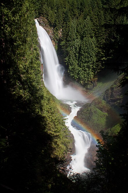
 At the town of Gold Bar, be sure to stop at Wallace Falls state park. The center of his park is the 265-foot waterfall, accessed by a trail. The highway rejoins the Puget Sound at the port city of Everett, which is also the end of the loop.
Eat
Zeke's Drive In Just outside of Goldbar, Zeke's is a solid roadside shake and burger joint. The portions are large, the burgers are pretty good and the fries are fries are awesome. I stop there every time I drive Highway 2.
Stay safe
Fuel
After you pass Marblemount on the North Cascades Highway (going eastbound), there is no gas for 70 miles until Mazama. There is also no cell phone coverage (no matter which carrier) from Ross Lake to Mazama. If you need assistance, you'll have to flag down someone with a two-way radio, or obtain a lift.
Avalanches
In the Cascade Mountains (which divide the state into halves) there can be significant snow accumulations during the late fall and winter months. This poses a danger for avalanches whenever these areas experience warm up periods, regardless of how brief they may be. Washington Pass is at an elevation of 5477 ft. (1669 m), and can have snowfall on any day of the year. Mountain passes are sometimes closed for avalanche control and may effect travel plans. Check the Washington State Department of Transportation website for information regarding Avalanche control.
If going into the mountains during winter and early spring months, refer to the Northwest Weather and Avalanche Center website for information regarding the current avalanche dangers throughout the Cascade region of the state.
Go next
- Seattle
- Olympic National Park Accessed from Whidbey Island or Seattle via ferry.
- Vancouver Just about 1.5 hours from Burlington
- The San Juan Islands can be reached on a side trip by ferry from Anacortes on Washington State Ferry.
- Victoria This city with a British charm can be reached from Anacortes by Washington State Ferry, but due to its schedules it is impossible to do a day trip.
The North Cascade Loop
Timezone:MultipleCoordinates:48.08, 238.83
