Xanthi - city in Thrace, Greece
Xanthi (Greek: Ξάνθη) is in Western Thrace. It's the capital city of Xanthi Prefecture.

Understand
History
The perhaps overly exciting history of Thrace, characterized by attacks by neighboring peoples, catastrophes, ethnic conflicts and civil wars, prevented a normal development of villages into cities. The city was conquered by the Ottomans in 1361. Unlike other parts of Greece that were affected by the population exchange between Turkey and Greece, Western Thrace was exempt from this agreement. Hence there is a higher proportion of Muslim population in this part of Greece.
Get in
By plane
The closest airport is "Alexander the Great" airport in Kavala, about 20 km away. Planes, mostly tourist charters, fly all over Europe.
Aegean (Flights to/from Athens daily)
By regional coach
The Bus stand 📍 Interurban coaches ("KTEL" buses) are by far the most convenient way to travel around Greece, as well as for intra-regional travelling. There is frequent bus service from Athens Kifisos Station to Xanthi, as well as from Thessaloniki bus terminal "Macedonia" to Xanthi.
By train
Railway station 📍 - Trains OSE connect Xanthi to other cities in Greece. Travelling with ordinary trains can be cheaper, although a little bit slower, whereas choosing a fancy faster Intercity train will cost the same amount of money, or even more than a KTEL bus.
Get around
As Xanthi is a small town, it's easy to explore it on foot.
See
- Folk Art Museum, 7, Antika St, 41.143552°, 24.887616°. The museum is housed in two three-story buildings, built next to each other and dating back to 1860. They were the private residence of two tobacco tradesmen and still have their inside walls decorated by remarkable paintings. 2016-02-19
- Public Paint Gallery, Orfeus & Pindaro St, 41.143296°, 24.888062°. 2016-02-19
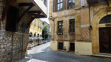
- Old town, 41.14006°, 24.88595°. Xanthi is famous for its old town with many pubs and restaurants. A walk through the old town combined with pub visits along the streets or in the backyards is a really worthwhile experience. Once a year, in the end of summer, the Old town Festival takes place, with music, food and drinks everywhere along the old streets. 2018-03-17
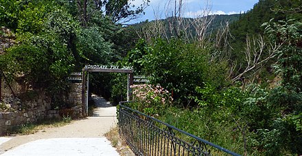
- Monastery of Taxiarchon & Kaliva Castle (Ιερά Μόνη Παμμεγίστων Ταξιαρχών), 41.1480°, 24.8822°. The Byzantine castle ruins are uphill of the Taxiarchon monastery. The drive on the dirt track is worthwhile because of a small chapel on the hill, above the ruins. The view of the surroundings is more beautiful than the ruins itself. 2018-03-17
- Monastery of Panagia Archaggeliotissa (Ι.Μ. Παναγίας Αρχαγγελιώτισσας), 41.1486°, 24.8949°. 2018-03-17
- Monastery Panagia Kalamou, 41.1573°, 24.8857°. 2018-06-11
- House of Shadow, 41.14310°, 24.88725°. Very worth seeing art museum, in which the shadow cast of the exhibited objects creates fascinating impressions. 2018-06-11
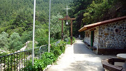
- Rock chapel of St. Georg, 41.1496°, 24.8897°. Interesting chapel at the end of the trail along the river. 2018-06-11
Outside the city:

- Thracian Meteora, 41.1927°, 25.0841°. Rock formation at Iasmos, which reminds of the well-known Meteora near Kalambaka. 2018-11-25
- Anastasioupolis. An ancient ruined city with a special "lost place" atmosphere on Lake Vistonia, not far from Porto Lagos.
- Kioutouklou Baba Tekke. The Tekes Kioutouklou Baba is an Ottoman tomb that is estimated to date from the 15th to 16th centuries. Today only the mausoleum (Tourbes) is preserved. It is an octagonal stone building with a domed roof. Inside is the hermit's grave, which is covered with a green cloth. The visitor can see the carved symbols of Bektashism such as ax and kioulachi. The monument was probably erected on the ruins of an earlier Christian church. It is a religious space for Muslims and Christians today. For the Muslims the tomb (Tourbes) of Kioutouklou Baba, while the eastern part of the monument was converted by Christians into a provisional church of St. George.
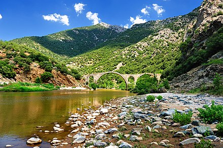
- Polyanthos Bridge. It is a remarkable medieval stone bridge over the Kompsatos river. The two large arches of the bridge are 21.8 and 17 m wide and the height of the arch is 12 m. The western of the original three arches has collapsed. From the parking lot on the street, a footpath goes uphill for about 10 minutes to the bridge.
- Thracian Meteora, 41.1927°, 25.0841°. Interesting rock formation near Iasmos, which is reminiscent of the famous Meteora near Kalabaka.
- Abdera. Was a major ancient Thracian port city and home to the philosophers Democritus and Protagoras. However, it lost its importance in Roman times. The reason for the settlement of this area was, on the one hand, the strategically important location on the Via Egnatia, the most important trade route from Rome to Constantinople until Roman times. The city was also on the important shipping route to the Black Sea: the Roman Empire obtained part of its grain from what is now Ukraine. On the other hand, the Thracian hinterland contributed to the prosperity of the colonists and the city of Abdera with fertile arable and pasture land, rich forest in the valleys of the Nestos and its tributaries, fish-rich waters and precious metal deposits in the mountains. Today there are some must-see ruins and an archaeological museum in the modern village of Avdira. In addition, the nearby beaches are among the best in the region.
- Nestos. 15 km west of Xanthi is the Nestos nature reserve, which is known for its special natural beauty and animal wealth. The Nestos Gorge near Toxotes is particularly worth seeing.
Do
- Walk along the river, 41.14511°, 24.89026°. next to the pedestrian bridge, which connects the old town with the district to the east of it, begins the approximately 500 m long promenade and plant path called "Monopati tis zois". Plants are labeled in Greek. The path leads along the river through beautiful countryside. 2018-06-11
- Carnival of Xanthi (Xanthi Carnival), 41.14007°, 24.887384°. A three-week-long event held every year since 1966. It features a vast array of concerts, dance, drama and visual arts. The parade and the traditional puppet burning takes place to end the carnival event. 2020-02-15
- Old town festival. In the first week of September, the Old Town Festival takes place with a lot of music, dance performances, food and drink. 2018-06-11
Buy
- Kariokes - A tasty praline with walnuts and chocolate, one of Xanthi's specialties, which can be found in all the sweets shops around the old town.
Eat
- Fanarakia tavern, Georgiou Stavrou 18 (1 minute walk from the central square of the city), 41.14045°, 24.88786°, +30 25410 73606. Traditional tavern since 1948
- Xanthippi, 1st km Xanthis-Stavroupolis (northern part of the city), 41.1471°, 24.8865°, +30 2541 023627. Xanthippi is a modern restaurant with traditional flavours from Greece and the Balkans. It offers a spectacular view of the city and the valley of Xanthi.
- Palea Polis, Evripidi Hasirtzoglou 7, 41.14196°, 24.88724°, +30 2541 068685. Some interesting Thracian food. 2018-06-11
- O Kipos, 41.14405°, 24.89056°, +30 2541 069018. Nice seats in the shade of tall trees 2018-06-11
- Melathron, 41.14433°, 24.89170°, +30 2541 074122. In the summer with beautiful seating under tall trees 2018-06-11
- Taverna Kottani, 41.3266°, 25.0679°, +30 694 500 9855. Exceptional local cuisine in a 200 year old traditional house in the Rhodope Mountains. Worth the very arduous approach 2018-06-11
- To Pilima, 41.1835°, 24.8373°. popular restaurant destination in beautiful surroundings about 10 km north of Xanthi 2018-08-16
Drink
Because of the relatively high proportion of young people through the university, Xanthi has a good nightlife relative to its size. In and around the old town is the center of the nightlife. Many very nice bars are either directly in the streets or in backyards.
Sleep
Budget
- Filoxenia Hotel, Toxotes (village of Toxotes, 10 km from Xanthi). Check-in: 1PM, check-out: noon. Filoxenia hotel is next to Nestos river.
- Xanthi Hotel, Lefkippou 14, +30 25410 23242. 2016-02-19
- Xanthippion Hotel, 28is Oktovriou 212, +30 2541 077061. Has a pretty stately exterior presence and features breakfast for a surcharge. 2016-02-19
- Orfeas Hotel, 40, M. Karaoli, +30 25410 20121. 2016-02-19
Mid-range
- Elena Hotel, Leoforos Stratou 2 (next to the river Kosinthos), 41.141291°, 24.895695°, +30 25410 63901-3. Elena hotel is a 3-star hotel, a few steps from Emporiou square. from $63 per night
- Nestos Hotel, 41.126428°, 24.884436°. Check-in: 14:00, check-out: 12:00 - 13:00. A 3-star hotel. from 36 euro
- Le Chalet, Pigadia Xanthis, 41.1243°, 24.9518°, +30 2541 068511. 2019-09-11
Splurge
- Z Palace and Congress Center, Georgiou Kondili street (in the entrance of the city), 41.126812°, 24.891688°, +30 25410 64414. Z Palace is a 5-star hotel.
- Elisso Xenia Hotel, Vas. Sofias 9 (next to the river Kosinthos), 41.143534°, 24.889326°, +30 25410 84400, +30 25410 84888. Elisso hotel is a 4-star hotel. 85$ par night (2016)
- Hotel 1000 Colors, Latomia (next to the casino), 41.140235°, 24.868133°, +30 25410 84805. Nice deck and pool, with free breakfast and bar and restaurant.
Connect
Most pubs and restaurants in the old town have free WIFI
Go next
- Nestos: natural reserve area of special beauty in landscape, and archaeological site such as Abdera.
- The villages and ancient ruins, such as Anastasiopolis (Peritheorion), around lake Vistonida
- Stavroupoli - Traditional village set on a scenic valley among forests and waterfalls. Some 30 km northwest of Xanthi by scenic Drama road or by train and gate to the Rhodope Mountains
- Kavala: one of the most beautiful towns of Greece
- Komotini: provincial town with strong influence of Muslim architecture
- Alexandroupolis: Harbour town with ferries to Samothrace Island
Xanthi
cityofxanthi.grPostal code:671 00Date Time:Please wait...Timezone:Europe/AthensPopulation:56,122Coordinates:41.13, 24.88
Nomós Xánthis
2nd-order administrative division
East Macedonia and Thrace
Primary administrative division