Al Shamal - administrative territorial entity of Qatar
Al Shamal is a municipality in the state of Qatar. The seaside teems with local dhow boats. Al Ruwais is part of a conglomeration of towns in the municipality of Madinat ash Shamal, including Al Ruwais (little more than a sleepy fishing village the northernmost city of the Qatar peninsula) and Abu Dahlouf.
Get in
Route 101 and 100 buses (timetable) travel from Al Ghanim Bus Station, Doha, to Al Ruwais and its surrounding towns regularly, with the journey taking 2 hours and 2½ hours respectively. The first service to Al Ruwais leaves Doha at 06:20, while the last bus back to Doha departs the bus station at 20:35. Buses can be affected by service changes and disruptions, so it is recommended you call Mowasalat to confirm first on +974 4458 8888.
The journey to Al Ruwais from Doha by road is just over 110 km, the furthest point from the capital in the country. The journey should take about an hour and 20 minutes along the Al Shamal Road.
Get around
By car
The Q1 highway traverses half of Al Shamal. The other half can be accessed via Al Areesh Rd.
See

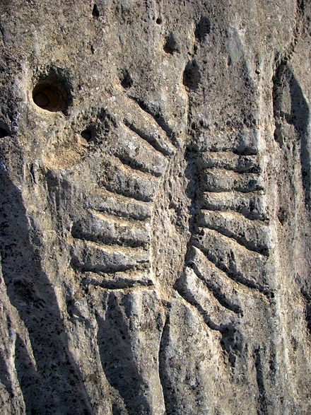
- Al Jassassiyeh Carvings (Al Jassassiya), 25.951663°, 51.406085°. A collection of about 900 petroglyphs, depicting such subjects as local fauna and boats. There are also geometric cup-shaped depressions, thought to have been used for traditional Arabian games using stones as counters. Recent studies date the oldest of these carvings to about 250 years old. Free
- Al Rakiyat Fort (Al-Rekayat Fort), 15 km north of Zubarah, next to a camel farm (turn inland at the Al-Khuwair radio station, drive 200 m off-road, 4WD not required), 26.05127°, 51.130453°. 24 hr. Built between the 17th and 19th centuries, restored in 1988. The fort is notable for having three square towers and one round tower, and was constructed of coral, limestone, and mud brick. Free
- Al Thughab Fort (Al Thaghab Fort), 26.032718°, 51.117129°. 24 hr. Built between the 17th and 19th centuries and restored in 2003. Similar to the fort at Al Rakiyat, this fort also features three square towers and one round tower. Free
- Al Ghariya (Al Ghariyah), Al Shamal Rd (Q1), 26.078824°, 51.358497°. A photogenic partially abandoned fishing village, active during Qatar's pearling years. There is also a good beach with fishing spots a bit further north of the old Scout Camp.
- Al Jemail (Al Jumail), 26.094867°, 51.154166°. An abandoned fishing village, founded in the early 17th century and fully abandoned in the 1970s with the shift of Qatar's economy to one based on mineral resources. The site is now under the protection of the Ministry of Arts, Culture and Heritage, and can only be visited after prior approval by the Qatar Museum Authority. Arrangements can also be made through Doha-based tour groups.
- Al Khuwair, 26.068676°, 51.083763°. A traditional fishing village abandoned in the 1970s. The name 'khuwair' refers to a small seawater canal.
- Al Areesh, 26.050950°, 51.056825°. An abandoned fishing village, inhabited from the early 19th to late 20th centuries. 'Areesh' is the Arabic word for a shelter made from date palm fronds.

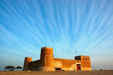
- Al Zubarah Fort, 25.978611°, 51.026389°. An ancient fort, and a museum. Listed as a UNESCO World Heritage site since 2013 - situated just 100 km west of Doha lies the town of Al Zubarah, an important archaeological site famous for its old fort. This fort-turned-museum was constructed in 1938 during the reign of Sheikh Abdullah Bin Jassim Al-Thani and was erected on the ruins of a neighbouring fort. The fort itself is square-shaped with circular towers in three of its corners and a rectangular tower in the fourth. With high, thick walls, this fort also served as a coast-guard station and, until the mid-1980s, was used by the military. The nearby archaeological site of the town appears to be closed. Free 2019-09-03
- It is possible to get to the fort solely by public transport. The Route 100 bus () towards Al Shamal runs return from Al Ghanim Bus Station three times a day. The journey takes about two hours each way. If you are planning on a day trip from Doha, the only option is to take the first departure from Doha at 10:15 and catch the last 16:43 return bus at Zubarah back to the city. It will give you about 4 and a half hours at the fort, which is more than enough time to observe the surroundings. An alternative for those wish to spend more than a day around the Qatari countryside is to catch the 18:12 Route 100 bus at Zubarah onward to one of the nearby towns, such as the northernmost seaside village of Al Ruwais, where you can catch a later Route 101 evening bus back to Doha. Ticketing information is included in the Qatar article.
- Umm Al Maa (ام الماء). Archaeological site most notable for its ancient cemetery, which is thought to date to the Bronze Age. The site also includes an 19th century fort. 2021-11-24
Do
- Fuwairit Beach, Al Shamal Rd (Q1) (the signpost for the beach is just before Bridge 79), 26.046913°, 51.360712°. Popular with kitesurfers, and notable for unusual eroded rock formations. Be careful of rocks in the water.
- Ruwais Beach (Abu Dhalouf Beach), Al Shamal Rd (Q1), 26.143188°, 51.187059°. This quiet beachfront is located directly on a small spit directly north of Al Ruwais, and has a few coves and inlets with picnic benches and shaded areas, and toilets. Dugongs and flamingos can occasionally be spotted here, and at high tide visitors can catch shrimp and crabs.
Buy
Eat
- Iskendar Kebab, Al Ruwais (towards the beach). Offers great fatayer and shwarma.
Drink
Sleep
- Al Ghariya Beach Resort, 26.066026°, 51.3634°, +974 4472 8000, +974 4472 8822, alghariyaresorts@hotmail.com.
- Camping. The beaches at Al Ghariyah and Fuwairat are well-suited for camping (see listings above).
Stay healthy
HMC operates an emergency department at its local clinic here.
- Al Shamal Health Center, Abu Dhalouf Rd, 26.135868°, 51.203495°, +974 4473 1232.
Go next
Ash Shamal
Date Time:Please wait...Timezone:Asia/QatarCoordinates:26.14, 51.22
Madīnat ash Shamāl
Primary administrative division