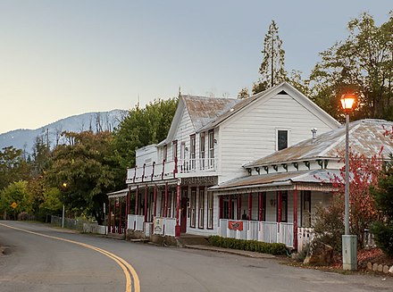
French Gulch - census-designated place in Shasta County, California
 French Gulch is a community of 350 people (2010) in Shasta County in the Shasta Cascades region of California. The French Gulch Historic District was listed on the National Register of Historic Places in 1972.
Get in
The optimal way to go to French Gulch is by car. Be sure to bring chains for your tires in winter.
Directions from Redding: Go west on CA 299 W until you reach it.
Get around
The town of French Gulch is small enough that you can get around by car.
See
French Gulch Historic District
The historic district listing included nine contributing buildings and two contributing sites on 180 acres (0.73 km²). It runs along both sides of Main St. (which has also been referred to as French Gulch Rd.) through a historic mining town.
It includes:
- Feeny Hotel (1887), still in operation in 1970, as "French Gulch Hotel".
- Franck's Store (1867), stone building of store founded 1854; owner's descendants still operated store in 1970.
- Franck Residence (c.1860s), west side of Main St. One-story wood frame house.
- Gartland Cabin (c.1856). Oldest surviving building in French Gulch.
- Commercial buildings and residences within a large north-south oriented rectangle 1,750 by 4,000 feet (530 m × 1,220 m) encompassing both sides of Main St.
Whiskeytown Lake
Whiskeytown Lake is one of two major lakes within 50 miles of Redding, CA. It is smaller, so it is by far the least crowded. It is best to visit in the fall.
Park headquarters
This place offers rangers to ask for help and information, and a gift shop. It shares a parking lot with the trailhead of the Shasta Divide Nature Trail. For visitor information, call +1 530 246-1225 .
Do
The closest outdoor recreation areas are Whiskeytown Lake (see above), Whiskeytown Falls, and the Carr Powerhouse area.
Whiskeytown Falls
These falls are odd in that they flow a bit at a more horizontal slope than most others. It is a strenuous hike there, but you'll be glad you did. If you can muster enough energy, there is also a trail at the Falls that takes you eventually to Shasta Bally.
Carr Powerhouse Area
Best known for its gold panning and nice picnicking areas, this goes from a creek and an old house to the Mill Creek Trail, the El Dorado Mine Loop Trail, and the Tower Gravesite trail. The latter has many fruit trees, and is the least strenuous. Along the creek in the summer, there are many monarch butterflies.
Buy
Shopping is not a major industry in French Gulch.
Eat
- French Gulch Hotel, 14138 Main St., +1 530 359-2112. A nice place to eat in French Gulch is the French Gulch Hotel, which, of course, doubles as a hotel.
Drink
Sleep
- French Gulch Hotel, 14138 Main St., +1 530 359-2112. The French Gulch Hotel, which doubles as a restaurant, is where most travellers stay in French Gulch.
Go next
French Gulch
Postal code:96033Date Time:Please wait...Timezone:America/Los_AngelesPopulation:373Coordinates:40.71, -122.64
Shasta County
2nd-order administrative division
California
Primary administrative division
United States
usa.govPopulation:327.2 MDial code:+1Currency:Dollar (USD)Voltage:120 V, 240 V, 60 HzNEMA 14-30NEMA 14-50