Kastamonu - central district and city in Kastamonu province, Turkey
Kastamonu is an inland city near the Black Sea coast, in Turkey.
Understand

With a population of 124,000 as of 2020, present-day Kastamonu is one of the smaller mid-sized cities of Turkey.
Kastamonu is strung along the banks of the Karaçomak River — the only flat ground of this mountainous area with a sparse forest cover. The southern part forms the historic core (although the traditional cityscape is partially pierced by modern concrete constructions), while the northern half is only decades old.
Get in
By bus
There are several daily buses from Istanbul and Ankara.
- A ride from Istanbul normally takes 8 to 8½ hours from the main otogar in the European Side, and about an hour less than that from the smaller hubs in the Asian Side, including a break around the mid-way. However, there are some reports that some Kastamonu-based bus companies complete the same route in 12 hours, as they tend to stop at each and every town along the way. Metro Turizm and Ulusoy both are reliable nation-wide bus companies with quite frequent connections between Istanbul and Kastamonu. The price for a one-way ticket on this route ranges from 180 to 250 TL (2022).
- From/To Ankara, a bus ride, crossing the beautiful Ilgaz Mountains, takes around 4½ hours, including a stop about an hour south of Kastamonu, and costs 80-120 TL one-way. Metro Turizm offers connections on this route, too.
Direct buses to nearby locations on the Black Sea coast (e.g., Sinop) and to far away major cities of the country (e.g., Izmir) are also available, but for locations south of Ankara, you are better off taking the buses to Ankara and transfer there to save time.
Kastamonu's bus station 📍 (otogar) is at the northern outskirts of the city. The buses from Istanbul traverse the city in its entirety before arriving at the otogar, so it's possible to get off at the city centre. If you somehow end up at the otogar, walk to the bus stop on the road just outside, and catch the urban buses into the centre for 4.80 TL. They are frequent with 5-min intervals and the trip takes about 15 minutes.
Metro Turizm also has offices on the main street downtown where you can buy tickets and take the free shuttle buses to either the otogar or the other intercity bus stop south of the city (depending on your direction) on the way out.
By plane
The local airport 📍 (IATA: KFS) is 12 km southeast of the city and has a single daily connection with Istanbul Airport.
The other relatively close by airports are in Ankara (Esenboğa) and Sinop.
By car
Kastamonu lies in a relatively remote location, off the major highways traversing the country.
- From Istanbul, the easiest route would be to take the motorway/toll-road O-4/E80 eastwards until Gerede exit, then hitting northwards D755 30 km east of Gerede. D755 will bring you to Karabük, from where you should pick eastwards D030 to Kastamonu, via Araç. The road is quite winding at parts (especially as you get closer to Kastamonu), although it is mostly a divided highway.
- From Ankara, the easiest route is taking eastwards D140 to Kalecik via Akyurt first. From Kalecik, hit northwards D765, which will bring you to Kastamonu via Çankırı and Ilgaz. The road leads across a 1800-odd meters high pass through the Ilgaz Mountains before arriving at Kastamonu, and is unique in Turkish highway system that it wasn't surfaced by the usual asphalt concrete but rather by cobblestones to assist the vehicles in icy conditions.
Get around
The main road extends along the both banks of the river that bisects the city: the northbound traffic follows the lanes on the eastern bank, while the southbound traffic uses the lanes on the western, with numerous pedestrian and vehicular bridges connecting them. There is a wide array of purple public buses plying up and down the whole length of this road, costing 4.80 TL one-way (2022). The neighbourhoods and alleys on either side of the river aren't served by the public transportation; however the distances are short, so walking around is a feasible option.
See
 The old town 📍 is dotted by historic half-timbered houses (although many rundown), elegant 19th century stone buildings, numerous mosques dating back to the Candaroğlu and Ottoman eras, and charming ancient bazaars; on the whole it is quite similar to nearby and much better known Safranbolu, although unlike there, Kastamonu's old quarter is partly replaced by modern, ugly buildings. On an outcrop (over 100 m higher than the city itself) to the southwest is the quite well-preserved citadel 📍 (free admission as of Apr 2011), affording a panorama of much of the city including the old town. The foundations of the citadel date back to the Byzantines, however it was the Candaroğlu who rebuilt it in its current plan. The climb up there along the alleys of the old town is a bit strenuous (and takes around 20 minutes) but the view is worth the effort.
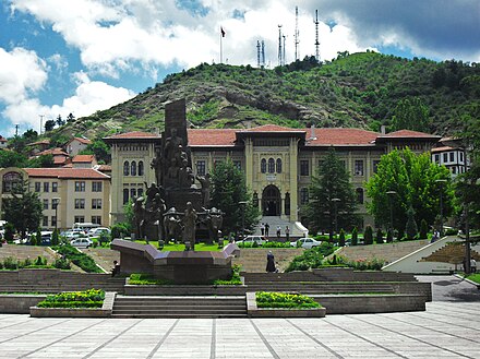
The river is crossed by, in addition to numerous modern ones, the 16th-century Nasrullah Bridge 📍, a stone humpback span with two arches out of the original five as it had its both ends extensively rebuilt to allow for the passage of modern roads. Beyond the river, at the Republic Square stands a 1990 monument 📍 commemorating the venture of supplying the frontline via regional routes during the Turkish War of Independence. The foremost figure represents Şerife Bacı, a local who died due to cold exposure during the endeavour. Behind the monument is the governor's office 📍, a fine example of late Ottoman architecture. It is backed by a pleasant clock tower 📍, also from the late Ottoman period, on the adjacent hilltop.
Do
Horse riding in Daday, a nearby town.
Buy
- Local sweet halva (çekme helvası) can be found at stores all over the city, starting from 1 TL for 100-g packages or 2 TL for 300-g packages.
- There is a large shopping mall 📍 at about the midway of the main street, between the old town and the newer northern suburbs. In addition to a number of other stores, it hosts a large Migros supermarket.
Eat
Local etli ekmek is kind of a large pizza, topped by cheese and spicy bacons (pastırma), quite dissimilar to the dish known by the same name in the Central Anatolia city of Konya. You'll find numerous eateries all around the city serving etli ekmek, and along with a soup and some salad, it costs around 7-8 TL.
Drink
Sleep
There are hotels along the main street. However, if you happen to show up during one of the numerous-year-round ceremonies held in the nearby military garrisons, when families from all over the country flow into the city to see their conscripted sons, be ready to face outrageously high rip-off rates or even unable to obtain a room.
Connect
The local telephone code is (+90) 366.
Nearby
 Kasaba 📍 is a village 17 km northwest of Kastamonu. As might be suggested by its name (a Turkish word denoting a larger town), it held a much greater importance in the past: it was a secondary seat to the Candaroğlu Kingdom prior to the Ottoman expansion, and in the early 20th century, it had a population exceeding 20,000 (comparable to Kastamonu of that time), down to barely more than 100 a century later.
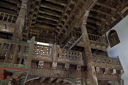
The only reason to head this way (and a good one at that) is Mahmut Bey Mosque, commissioned in 1366 by its eponym, who belonged to the Candaroğlu dynasty. It is one of the few Turkish mosques of completely wooden construction — its pretty elaborately carved pieces were all artfully jointed together without the use of any nails (hence its colloquial name, Çivisiz Cami, "the nailless mosque"), finished by delicate plant-dye ornaments, faded in the meantime. The overall effect is almost East Asia.
Driving to Kasaba is straightforward: take the road to Daday until Göçen, from where you will branch off for the final 3 km. By public transport, you may catch the minibuses bound for Daday up to the turn-off at Göçen, but from there you are likely on your own.
Go next

- İnebolu to the north is a historic town on the Black Sea.
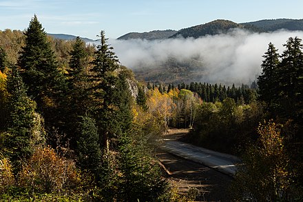
- Küre Mountains National Park to the northwest is an area of extreme natural beauty: lush forests, striking gorges, and a rich biodiversity.
- Safranbolu to the west is a World Heritage site for its very well preserved old town with whitewashed Ottoman houses.
- Ilgaz National Park to the south is a winter sports destination, offering an almost Nordic landscape in the middle of Turkey.
- Boyabat is to the east. Drop by to see its impressive citadel overlooking the river valley below on your way to Sinop, an ancient Black Sea port with excellent views.
Kastamonu
kastamonu.bel.trCide
2nd-order administrative division
Kastamonu
Primary administrative division