The Riga region on the Baltic Sea sits at the heart of Latvia, and is its political, population, and cultural center.
Cities
- Riga 📍 – The capital city of Latvia and the European Capital of Culture in 2014 with a long history.
- Limbaži
- Jūrmala 📍 – A popular holiday and sea resort town with wooden houses just west of Riga, which claims to have the longest beach in Northern Europe.
- Salacgrīva
- Saulkrasti
- Sigulda 📍 – A town in central Latvia with many interesting castles and historic points of interest. Probably, the most popular destination outside of Riga for foreign tourists, also due to its closeness.
- Tukums 📍 – A town some 70 km west of Riga. Not that exciting, but known for its affinity with roses, the Rose Festival, and the nearby Cinevilla, a dummy city and now theme park.
Other destinations
- Salaspils 📍 – 15 km southeast of Riga where Salaspils concentration camp was located.
- North Vidzeme Biosphere Reserve – A reserve that covers 6% of the territory of Latvia, and offers hiking trails, beaches, and nature education.
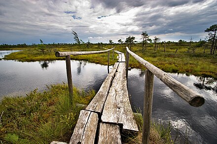
- Ķemeri National Park 📍 — A park mostly occupied by forests and mires, with boardwalk trails.
Understand
.jpg/440px-Jaunpils_castle_(1).jpg) In addition to the city of Riga, the most popular tourist destination in the country, there is the seaside resort of Jūrmala with its seaside wooden houses and numerous spas. Further west, there is Tukums, which houses a city built in 2004 only for the making of a film.
In addition to the city of Riga, the most popular tourist destination in the country, there is the seaside resort of Jūrmala with its seaside wooden houses and numerous spas. Further west, there is Tukums, which houses a city built in 2004 only for the making of a film.
The area is also rich in natural sites; Kemeri National Park with its forest and peat landscapes; to the north, the Baltic beaches offer a unique landscape between forest and pine and sea; and the town of Sigulda and its three castles, and also the gateway to the Gauja National Park, the oldest national park in the country.
Get in
1188.lv provides up-to-date bus and train schedules, route planner and prices.
All transport (bus, train, car) is spider web wise possible from Riga, mostly direct and quite frequent. The railway tracks and roads spread equally distributed in all possible land-based directions. This allows for convenient day trips to the below mentioned sites (even several ones) starting and finishing at Riga.
Get around
Travel around Riga can be less frequent, and sometimes it is even preferable to first going back to Riga and continuing from there.
See

- Pastarins Museum, Bisnieki, Zentene, 57.122963°, 23.018675°, +371 63154518, +371 28651091, +371 63142473, pastarinamuzejs@inbox.lv. W-Su 10:00-17:00. Baking bread, churning butter, field work, countryside goodies, games, nature trail, E. Birznieks-Upitis, Pastarins.
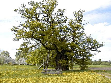
- Kaive oak (Kaives ozols, Oak of Ancestors), 57.064306°, 23.025528°, +371 63124451, tic@tukums.lv. It is the biggest oak in Baltics. It's older than 1000 years and 10 m round.
- Jaunmokas Castle / Palace (Jaunmokas Manor / Jaunmoku pils), Jaunmokas, Tumes pagasts, 56.9816°, 23.054°, +371 63107125, +371 26187442, +371 63124572 (museum), info@jaunmokupils.lv. M-Su 10:00-18:00 (museum). Forestry museum, guide, castle interior, the room of columns, lodging, horse-drawn carriage rides, the centre of Latvian ornament, herbal teas.
- Cinevilla Studios (Kinopilsēta "Cinevilla"), Vidusvecvagari, 56.878333°, 23.219167°, +371 28 606 677, mdambis@inbox.lv. Daily 10:00–19:00. It was built as a movies backlot, and is now a cinema theme park.
- Dunduri meadows (Dunduru pļavas), 56.8299353°, 23.4008537°, +371 67730078, pieriga@daba.gov.lv. Surrounded by forests these fields in Ķemeri National Park are a nice place to visit and observe wild horses and bulls. The location has an observation tower with roof, potentially good for 2-3 people for overnighting.
- Jaunpils Castle, Jaunpils, 56.730175°, 23.021294°, +371 63107082, +371 26101458, +371 63107081 (museum), info@jaunpilspils.lv. 10:00-17:00 (museum). Medieval castle, medieval tavern, medieval celebrations, dramatized tours, attractions, museum.
Do

-
The Great Ķemeri Moorland (inside Ķemeri National Park) (Lielais Ķemeru tīrelis), Slampes pagasts (there are frequent train connections towards Tukums with a stop in Ķemeri village, right in the middle of the Moorland; also, the major "highway" going east towards Tukums and Ventspils goes right through the Moorland), 56.90459°, 23.45363°, +371 67730078, pieriga@daba.gov.lv. Ķemeri is the third largest national park in Latvia, and popular for its extensive moorland, moorland lakes, a wooden footbridge, viewing tower, bird-watching, moss, cranberries, fierce plants. The park extends to the north and the south of the village with the same name. Only south you will find a trail made of planks across the swamp including an observation tower 📍 (but without roof, so not good for overnighting without tent) – see included track in the following. It seems that (from the satellite view) starting from the observation tower there is a trail leading even further south into the swamp, probably requiring rubber boots – check out the trail also included with this listing. Nevertheless, also northwest of Ķemeri village trails lead through the swamp, check them out on OpenStreetMap, which many mobile Apps like OsmAnd or Mapy.cz, etc. use, or any other preferred map.
-
The Great Ķemeri Moorland Trail (<span style="color:#008000; font-weight: bold;">green</span>). Distance: 11.24 km. 3–4 hr. Grade: easy. The trail starts and finishes at the Ķemeri village railway station. Download coordinates: GPX, KML.
-
Ķemeri Moorland (further into the swamp) Trail (<span style="color:#FF0000; font-weight: bold;">red</span>). Distance: 1 km. 1/2 hr. Grade: medium. Waterproof boots recommended. Start at the observation tower, from there the trail seems clearly visible. Note that this is a swamp with its common dangers, take precaution and do not walk on your own. Download coordinates: GPX, KML.
-
-
Lake Engure Nature Park (Engures ezera dabas parks), Engures pagasts, 57.260477°, 23.134706°, +371 29474420, eedp@inbox.lv. Orchid trail (start) 📍, bird-watching towers, coastal meadows, wild cows and horses, information stand. A comprehensive map can be found on the parks website.
-
Medieval Farm "Niedru lija", Jaunpils pagasts, 56.732998°, 23.016014°, +371 26336513, niedru.lija@inbox.lv. Medieval games, coin minting, school of knights, archery, spears, axe throwing, medieval meals, castle.
Eat
Drink
Sleep
In the following a list of various accommodation options in the region worth mentioning and outside of the above covered cities, towns, and parks:
- Jaunpils Castle, Jaunpils, 56.730465°, 23.021466°, +371 29442539, info@jaunpilspils.lv. Various accommodation options, inside the castle. Dorm from €15, Baron’s room from €95 2017-10-23
- Viesnīca Klidziņa, Rīgas iela 10, Skrīveri, 56.625277°, 25.0858212°, +371 26339971, +371 26308566, info@klidzina.lv. Good value for money. Drom from €12 2017-10-20
- Also check out the Dunduri meadows observation tower (see above), which has a roof, and is potentially good for 2-3 people for overnighting, if you bring a sleeping bag and mattress.
Go next
- Vidzeme – The most touristy region in Latvia with the Gauja National Park and its river valley, many medieval castles, estates and churches, and numerous interesting cities, towns and villages.
- Kurzeme – The region provides direct access to the Baltic sea with wild coast, beautiful lighthouses and sea resort towns. Preserved traditions and culture allowing visitors to visit various places such as old fishermen's villages of the Livonian time.
- Zemgale – Flattest region in Latvia, and famous for the neighbouring and historically related Jelgava Palace and Rundāle Palace, near Jelgava and Bauska, respectively.
- Latgale – A less touristy and more Russian-influenced region, but with the amazing Basilica of the Assumption near Daugavpils.