Riisitunturi National Park - national park in Posio, Finland
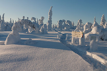
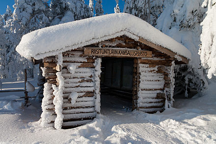 Riisitunturi National Park is in the southern part of Finnish Lapland near Posio. The park covers an area of 77 km² and represents the fell and hill landscapes in Koillismaa. There are colourful hanging bogs on the slopes of the Riisitunturi Fell and scenery over the Lakes Kitkajärvet and the forest landscape of Posio. The snowy forests wintertime are worth seeing by themselves.
There is a trail network suitable for hiking trips lasting a couple of days.
Nearby is the protected mire area of Karitunturi Fell and old-growth forest.
Understand
Visitors have to be able to take care of themselves, at least in the winter, as the area is remote and wilderness-like. The Noukavaara road is not ploughed in the winter and skiing tracks may sometimes be in poor condition. Do not expect to get quick help in emergencies. There are areas without phone coverage (try to climb higher).
Some experience in hiking and skiing in the forest are required, as the terrain is quite difficult in some places.
There is no official local visitor centre. The Oulanka visitor centre and Kuusamo customer service act as visitor centres, providing information, advice, maps etc.
- Oulanka Visitor Centre, Liikasenvaarantie 132, +358 20-639-6850, oulanka@metsa.fi. Visitor centre. Exhibitions. Child backpack carriers and snowshoes for rent. Lunch. Accessible by wheelchair. Free. Guided tours €50/group 2017-01-27
- Kuusamo Customer Service Karhuntassu, Torangintaival 2, +358 20-639-6804, karhuntassu@metsa.fi. Colocated with Hannu Hautala Nature Photography Centre. Accessible by wheelchair with an assistant. Free. The photography exhibitions have an entry fee 2017-01-27
History
The park was established in 1982.
Landscape
Flora and fauna
Climate
Get in
The park is about 30 km from the centre of Posio. The nearest airport is in Kuusamo, about 54 km from the park, the nearest railway station in Kemijärvi, about 130 km from the park. The village Tolva is near Riisitunturi and is the starting point of a skiing trail into the park. There is a taxi in the village.
There are daily coach connections from Rovaniemi and Kuusamo to Posio, the latter driving along road 81 (Kuusamo-Posio-Rovaniemi), quite near the Kirintövaara starting point in the south end of the park.
The Posio-Rovaniemi snow mobile route passes by the western edge of the park. The Karitunturi Ahmatupa open wilderness hut near Karritunturi is by this route. Posio is 10 km from the hut, 16 km from the national park by the Riisitunturi hiking trail. The trail is a skiing route in winter to the huts. Going by ski to the national park from here you need to plan your own route and make your own trail, as the hiking route probably is too steep.
Fees and permits
There are no entry or hiking fees.
Get around
There are hiking and skiing routes in the park. You are allowed to walk and ski outside the trails, except for possible restricted areas. There are shelters and open wilderness huts in the area.
See
Do
Hiking
The park offers hiking possibilities both in winter and in summer time.
- Riisin Rääpäsy Trail (4.3 km round-trip). Very nice hike featuring Riisitunturi Fell, the Open Wilderness Hut, Ikkunalampi Pond, the hanging bogs. It starts from Riisitunturi starting point. The hike is especially nice during winter time.
- Riisitunturi trail (33 km one way) from Posio to Tolva through Karitunturi mire protection area and the national park. Several huts and lean-to shelters on the way.
Cross-country skiing
From mid-January to late April there is a 7-km-long, maintained ski track in the National Park. The track starts from Korpihilla Café's parking lot and ends to the fell hut on top of Riisitunturi. The track is fairly easy.
Buy
Eat
The stove of the open wilderness huts and the day hut can be used for cooking. Open fire can be used at the lean-to shelters and campfire sites (unless there is a wildfire warning). A portable stove can be used anywhere. Catering services may be available also in the park, check with Posio tourist info or local businesses.
- Korpihilla Café and Delicacy Shop (Holtinojantie 5, 97985 Tolva, Posio), +358 400 901 910. Korpihilla is in the village of Tolva next to the Riisintunturi National Park. Korpihilla offers home made delicacies made from local, natural ingredients. Their signature drink "Kuohuva Kuusenkerkkäjuoma" has won many awards.
Drink
The water in the brook and lakes has not been tested, use your judgement. Boil it for a minute or two or use water from the customer service points if unsure.
Sleep

The open wilderness hut offers shelter for independent hikers free of charge. The Riisitunturi hut is 4.6 km from Noukavaara starting point and 1.5 km from Riisitunturi starting point. There is a day hut near Karitunturi, which can be used for overnight stay in emergencies. In peak season you should have a tent. There are also lean-to shelters.
Lodging
- Riisitunturi Open Wilderness Hut, 66.22795°, 28.56663°. 2017-01-27
- Karitunturi Ahmatupa Open Wilderness Hut, 66.15870°, 28.30001°. Open wilderness hut on the trail southwards from the park. 2017-01-27
Camping
There are no camping sites in the park. One can camp by the Riisitunturi and Karitunturi huts.
Backcountry
Backcountry camping should be avoided, as the park is small and quite popular.
Stay safe
Be sure to understand the implications of travelling in cold weather, if you are going to the park in wintertime without experienced guides taking the responsibility.
Go next
Riisitunturi National Park
nationalparks.fi/riisitunturinpluontoon.fi/riisitunturiutinaturen.fi/riisitunturiDate Time:Please wait...Timezone:Europe/HelsinkiCoordinates:66.23, 28.50
Lapland
Primary administrative division