Sierra Nevada - mountain range in the Western United States
For other places with the same name, see Sierra Nevada (disambiguation).

The Sierra Nevada region of California is its alpine region, covering a large portion of the state's inland territory. Rugged mountains and awe-inspiring canyons in the area's national parks and forests are truly part of the United States' national wilderness treasures.
It's a region of grandiose sizes; Mount Whitney, the highest peak in the contiguous U.S., is here, as well as the giant sequoias, the tallest living things on earth. The human population, however, is relatively small. Most of the towns and cities in the Sierra Nevada region are ski resort towns, or gateways to the area's parks.
Regions
Lake Tahoe is a famous and popular destination with California residents. The lake is large yet at a high elevation; there are developments around the lake, along with lodging options and choices for recreational activity.
Sparsely populated Alpine County advertises itself with the slogan "two people per square mile and you", making it a good option for a quiet mountain getaway. Attractions include the hot spring pools at Grover Hot Springs State Park, amazing views of the Sierras from the Ebbetts Pass National Scenic Byway, and the excellent winter skiing at Kirkwood Mountain Resort.
Mariposa was the largest county in California at the time of statehood in 1850, but later ceded land that formed twelve other counties. Today it maintains a relatively small footprint in the Sierra Nevada foothills, but has kept one of the state's treasures: Yosemite National Park, home to impossibly tall granite cliffs, remote alpine wilderness, and an iconic valley.
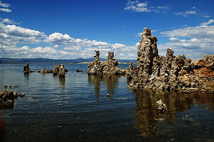
Remote and expansive Mono County is a destination for outdoor enthusiasts. It is the eastern gateway to Yosemite National Park, home to the Old West ghost town of Bodie, and Mammoth Lakes is a favorite winter skiing getaway. The gigantic Mono Lake is perhaps the county's premier attraction, a stopover for millions of migratory birds and thousands of tourists who explore its alkaline waters and bizarre tufa formations.
{{mapshape|type=geoshape|fill=|title=Eastern Sierra|wikidata=Q14214596}} {{mapshape|type=geoshape|fill=|title=Lake Tahoe|wikidata=Q169962}} {{mapshape|type=geoshape|fill=|title=Alpine County|wikidata=Q108077}} {{mapshape|type=geoshape|fill=|title=Mariposa County|wikidata=Q156191}} {{mapshape|type=geoshape|fill=|title=Mono County|wikidata=Q156366}}
Cities
Other destinations

- Yosemite National Park - a shrine to human foresight, strength of granite, power of glaciers, the persistence of life, and the tranquility of the High Sierra.
- Sequoia and Kings Canyon National Parks - Immense mountains, rugged foothills, deep canyons, vast caverns ... and the world's largest trees!
- Devils Postpile National Monument - protects and preserves the Devils Postpile formation, the high Rainbow Falls, and pristine mountain scenery
- Independence (California) - Manzanar National Historic Site, one of ten camps where Japanese American citizens and resident Japanese aliens were interned during World War II
- Sequoia National Forest
- Mono Lake
- Mount Whitney
- Rock Creek Lake
- White Mountains - Home to the bristlecone pines, trees that can live up to 5,000 years.
Understand
Location
The Sierra Nevada Mountains are located in eastern California. They stretch from the north of the state to the south, the southern ending being near Los Angeles. The southern parts of the Sierra Range include the highest mountains, such as Mount Whitney and Yosemite National Park. In the north, the mountains are generally not so high but the scenery is still known for being dramatic. However, the northern parts of the Sierras, which are heading towards the Cascades, have a few high volcanic peaks, like Mount Shasta and Mount Lassen.
History
The Sierras — especially the foothills — became populated by white settlers around 1850 due to the gold rush. This is when California became a state.
Climate
 Altitude in the Sierra Mountains results in the climate being not as hot as it would be at sea level. Snow can come at almost any time of the year, and temperatures can change quickly. As you go up into the mountains, it is forested until you reach the tops of the higher peaks. In these higher regions, there are no forests.
The lower parts of the Sierra Mountains (known as the "foothills") can get very hot and climatically have quite a lot in common with the Central Valley and the East Bay.
Get in
If traveling to Lake Tahoe, the nearest airport would be Reno/Tahoe International Airport in Neveda. Reno mostly flies throughout the continental United States. If traveling to Mammoth Lakes or Yosemite, the nearest commercial airport is Mammoth Yosemite Airport (MMH), there are year-round flights with United Express from Los Angeles. Other destinations are available during the summer. Several roads go through the Sierras, including I-80, US-50, CA-4, CA-88, CA-108, and CA-120. These roads can close in winter, however, and some of them close for large portions of the year.
Get around
Although roads such as the I-80 and US-50 make travel in parts of the mountains relatively easy, there are several things to consider when traveling in the Sierras:
Driving
- Many of the California state routes in the Sierras are closed in winter. Therefore, although they usually go far enough to reach major tourist sites and towns, they do not completely cross the mountains when winter closures come in. And even when the roads are open in winter, one is advised to bring chains. Even major roads like the I-80 have to close occasionally in bad weather.
- There are not many north-south roads. Nearly all roads cross the mountains east-west, since they connect populated areas, and are not primarily tourist routes. CA-49 is one of the few good north-south routes, although most north-south roads are twisty and slow due to the number of canyons they have to pass through. US-395 is a generally well-maintained north-south road that follows the Eastern Sierras through some sparsely populated but rather beautiful country, entering Nevada to serve Reno before heading back into California.
- A lot of California state highways go into the Sierras, but also end in the Sierras. For example, CA-203 goes west to Mammoth Lakes in the eastern Sierras and on to a pass of several thousand feet, but the road ends shortly after going over the pass, and does not go on to the Central Valley. Even worse, the CA-168 goes into the Sierras and reaches several thousand feet in elevation, comes to a dead end, only to start again on the other side of the mountains. There is no proper road connection between two parts of what seems to be the same highway.
Road Standards
Yes, traveling in the Sierras is much more difficult and requires more planning than most places. Generally, stick to state and national routes when possible - you can know two things with almost any California state routes:
- The road will be paved.
- The road will have two lanes at least, one for each direction. In some roads in the Sierras, passing roads also exist for short stretches.
Hiking
- Much of the Sierras is national parkland. This parkland has trails, and trail maps are often available in visitor centers. Trails will be of varying condition - trails in Yosemite Valley will be in much better condition than those on the edges of Kings Canyon, for example.
- For those who are ambitious, there are hiking trails in the Sierras which go hundreds of miles over mountain passes and canyons. Other trails are shorter, but still, most trails in the Sierras are pretty long and tedious.
- The Sierras are not like the community park down the road: these mountains are filled with bears and other wild animals. Although these animals will not usually attack you unless you attack them first, they are still extremely dangerous and may attack you if you have food items. Just the sight of a plastic bag can make a bear's mouth water. Even in regions of the Sierras near urban areas, bears can be spotted.
- The Sierras are a big place. In other words, you can get lost, and that's definitely no fun. As pine trees cover much of the land, landmarks might not be within view when you're in the middle of a forest. Make sure you stick to hiking trails and that you have a map with you. For more information about preparing for dangers, scroll down to the "stay safe" section.
Stay safe
What is winter?
On maps of the Sierra, some roads will be marked "Closed in winter." Travelers are often advised to "carry chains in winter." You might think that such advice refers to that time of year the rest of the world calls "winter" which lasts from Winter Solstice through Spring Equinox. You would be wrong.
What Californians are referring to is the time of year when it snows in the Sierra. Snow can begin as early as October, and last as late as May. Roads may be closed as late as July. When snow falls in mid October, it usually kills a few unprepared backpackers in the Sierra who hadn't carefully checked the weather reports. If you don't have chains during an early October or late May snowstorm, continuing to drive may kill you, too.
The Sierras are a high mountain environment containing some of the snowiest places in the US. During winter you should always carry tire chains in your car and know how to use them.
When hiking or backpacking where you will be far from help, check the weather first. The first snows of winter may come earlier than you expect, such as during early fall. In summer, be careful about heatwaves — while higher-elevation trailheads could maintain mild to warm summer temperatures, lower elevations such as river valleys and canyons can experience vastly higher temperatures. Each thousand feet in each direction can change temperature by several degrees Fahrenheit, which combined with daytime heat or the arrival of a blizzard can be fatal to the unprepared.
In summer during the North American Monsoon, thunderstorms often build up near the crest of the Sierra Nevada, particularly during late afternoon. It is unwise to be in a high, treeless place during a thunderstorm. If hiking far in summer, it's a good idea to carry a light rain jacket just in case a thunderstorm pops up out of nowhere.
Bears are endemic to most parts of the Sierras, and unfortunately some of them have realized that humans are a source of delicious food and garbage and will wander into towns. If you are camping, be sure to research how to "bear-proof" your campsite. Note that it's not just food and food-related trash that attract bears, but anything with an attractive scent. E.g. toothpaste and even soap are surprising favorites. Bears almost never attack humans unless severely provoked, but there is a risk of getting between a mother bear and her cubs, which can provoke an aggressive reaction.
In general, don't feed or touch any wildlife. Any animal may bite if startled or frightened, and some carry nasty diseases including rabies and bubonic plague.
Go next
- San Francisco is just a few hours west.
- The Gold Country where the California Gold Rush began is in the Western foothills of the Sierra. There are plenty of quaint historic towns to visit there when traveling to or from points west.
- If you're headed to Los Angeles or other places to the south, taking US 395 down the Eastern Sierra is a great scenic alternative to the monotony of traveling through California's Central Valley.
Sierra Nevada
Date Time:Please wait...Timezone:America/Los_AngelesCoordinates:37.73, -119.57
Mariposa County
2nd-order administrative division
California
Primary administrative division
United States
usa.govPopulation:327.2 MDial code:+1Currency:Dollar (USD)Voltage:120 V, 240 V, 60 HzNEMA 14-30NEMA 14-50