Skellig Michael - UNESCO heritage island off coast of Kerry, Ireland
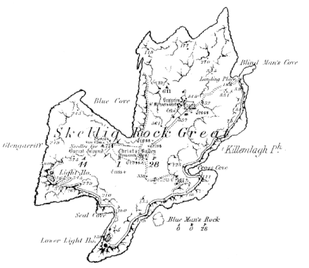
Skellig Michael (Sceilig Mhichíl) or "Great Skellig" is a small uninhabited island 12 km off the coast of County Kerry in southwest Ireland. Its twin crags, rising to 218 m (714 ft), have the remains of an ancient monastery perched above an often-roiling sea. The place is named for the Archangel Michael, as one of the few beings that could alight upon such a remote spot, and it's inscribed on the UNESCO World Heritage List.
Understand

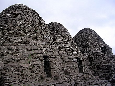
Skellig Michael was probably visited but uninhabited until a monastic settlement was founded here. This could have been as early as the 6th century, in the first great wave of religious settlements around these coasts. It's first reliably documented as suffering a Viking raid in 823 AD. The complex expanded, especially from the 11th century, and affiliated to the Augustinians. It was never a large community, perhaps 12 monks and an abbot, living and praying in their little beehive huts, tending their vegetable patches, then convening for mass. They built the Monastery on the east peak, the Hermitage on the south peak, and vertiginous paths up from the island's three landing points. In the 12th century they abandoned the place and decamped to Ballinskelligs Abbey on the mainland; the medieval climate deteriorated around that time, so their precarious settlement became untenable.
From the 1500s, Skellig Michael was a pilgrimage destination but had no permanent residents. In the 19th century two lighthouses were built so the island was again inhabited by a rota of lighthouse keepers. The second lighthouse still operates; it was rebuilt in the 1960s and automated in the 1980s. So the keepers left but tourists began to arrive: there are still no permanent residents or visitor facilities here but in summer there's a ranger, whose first task each morning is to advise the mainland boat operators whether it looks safe to come.
The island supports large numbers of gannet, fulmar, kittiwake, razorbill, common guillemot, Atlantic puffin, Storm petrels and Manx shearwaters. They mostly nest on the ground where they would be very vulnerable to predators. There are rabbits and mice here but no rats, and it's essential to keep it that way. The monastic structures are well-preserved in a remarkable scenic setting, and in 1996 Skellig Michael was inscribed as a UNESCO World Heritage Site. Although no great religious leaders or exiled Napoleons have been based here, in the 2010s it served as the refuge of none other than Luke Skywalker, in The Force Awakens and The Last Jedi Star Wars movies.
Get in
The island can only be reached by a small boat on a calm summer day; dogs, small children and anyone with impaired mobility may not land. Portmagee 📍 is the usual departure point, for a 45 min crossing. Boats sometimes sail from elsewhere along the Kerry coast.
Boats sail May-Sept and only 15 licensed boats may land per day, with a maximum 12 passengers - so that's only 180, to limit the footfall on the island and especially its precarious paths. Midsummer the boats are fully booked and with a waiting list, yet trips are often blown out by sea conditions, with no capacity to re-book those passengers for later. Each boat has a landing and re-embarkation slot that it must adhere to. It will therefore sail some time between 08:30 and 10:00. You have 2-3 hours on the island, then the return crossing is 45 min, so you'll return to harbour around 14:00-15:00.
By contrast, the non-landing trips (marketed as "eco-trips", though they burn the same amount of marine diesel) have a more relaxed schedule and sail later in the day. They've more flexibility to change route or go follow a dolphin pod. And there are more of them, so you're likelier to get on, but should still book ahead. Expect to pay €100 pp for a landing tour and €40 for non-landing.
Licensed operators in 2021 include:
- from Portmagee: Casey's and Skellig Michael Cruises.
- from Derrynane: Skellig Tours.
- from Valentia Island, Ballinskelligs or Waterville there are no sailings in 2021.
Other boat operators are reputable but don't seek Skellig licences, as there are plenty of other places they can offer to take you, with less risk of sad headshakes and refunds all round.
Skellig Michael 📍 landing point is the piratically-named Blind Man's Cove near the northeast tip. If conditions are doubtful, the boat will just circle the island and not attempt a landing, or offer an in-shore Plan B trip, or not leave harbour at all. Disappointing if you've come a long way in hopes of a visit, but ask yourself this: would you rather be on the mainland jetty wishing you could have gone out, or upchucking into the Atlantic wishing you'd stayed ashore?
Get around
 There are no vehicles on the island, nor any concessions to visitors with impaired mobility.
A narrow trail, the "Lighthouse Road", starts at Blind Man's Cove (or East Landing) and skirts the east and south base of the cliffs. The monastic East Steps from this cove are impassable, since their lower section was dynamited during 19th century construction of the landing stage and trail. 200 m brings you to Cross Cove and South Landing, no longer used. There's a helipad and the start of the South Steps, the set you use to reach the monastery. The shore trail continues to the lighthouse, then to the disused lighthouse - they were built at the same time to create a double light that wouldn't be mistaken for any other - but this is closed to the public.
The South Steps are in a reasonable condition, but they are old, uneven and steep, with no safety rail against the precipitous drop, and there are 618 of them. (There were more below the Lighthouse Road to South Landing, but now impassable.) They bring you onto Christ's Saddle between the two peaks. The East Steps and the North Steps from the third landing area also lead here but are impassable, so the North Landing is nowadays a "blind cove" with no path out. From the saddle a cliff-edge path continues to the monastery on the east peak. The route to the hermitage on the south peak is impassable and that area is off-limits. Archaeologists have found traces of other steps around the island.
See
- Ashore in Portmagee before you sail, the Skellig Experience is a good introduction to the island. If the weather turns against you, it may be all you get to see.
- Marine life: on the boat, always be looking, you never know what might fleetingly appear. Seals and dolphins are not unusual, other cetaceans are rare, but what about that vast creature that left its footprints on Valentia Island - it must come up for air soon? Even if nothing shows, those beasties are doing you a favour, because gazing towards the middle distance and horizon will help to minimise sea-sickness.
- From the boat on the non-landing trips you see several features not visible from the island paths, such as the disused lighthouse, and other monastic stairways.
- Wailing Woman is a rock formation along the South Steps.
- Christ's Saddle has spectacular views of the South Peak.
- The Monastery and the monks' beehive huts are found towards the East Peak.
- Sea birds swirl all around, orbiting the great crags and gulfs on sharp wings.
- Little Skellig 📍 has 35,000 pairs of gannets. The islet is a nature reserve with sheer cliff sides, so landing is neither permitted nor possible. It was long supposed to be utterly uninhabitable, but in 2020 archaeologists found remains of an oratory and dwellings for one or two monks. No steps were found, they must have used a grappling hook and knotted rope to get ashore.
- Lemon Rock 📍 the last of the trio is a 20 m stone fang. In the legend of St Brendan the Navigator, he came across a lonely wave-dashed outcrop bearing Judas Iscariot, who was granted one day's leave per year from hell to perch upon it. That rock's GPS coordinates couldn't be read from the original manuscript but this place seems a good candidate.
- Puffin Island is geologically the east end of the chain, but it's very close to the mainland and quite a different experience. Other boats visit but if a trip advertised as "Skelligs" brought you here, you'd have cause to grind your gums; even that red-haired hitchhiker you picked up at Lemon Rock would be complaining.
Do
- Consider Plan B before you even go to the jetty. Trips are not infrequently called off so think of other attractions you could swiftly move on to, without wasting the morning pouring over maps and guidebooks, even this one.
- Have a last loo break before setting out. Only the seabirds are allowed to poop on the island, a right they vigorously exercise.
- May the 4th be with you: Star Wars Day is on that date, for obvious reasons. There are wordwide cosplay events, which sometimes include Skellig Michael because of its use as a film location. The landing tours only start later in that month but you could join a non-landing trip or get up a group for a charter, and marvel that even Chewbacca manages to turn green as he feeds the fish with his breakfast.
Buy
The island is a retail-free zone. That's maybe why the monks chose it.
Eat
There are no catering facilities on the island.
Bringing a picnic is a good idea but don't eat it around the monastery or Christ's Saddle, else the birds will mob the place and cover it in guano. The base of the steps near the helipad is a good sheltered spot.
Drink
- Carry water or other drinks with you, there's no water supply on the boats or island.
- Lots of pubs in Portmagee and elsewhere for when you return, but go easy on the drink the evening before your boat trip: think about that heaving ocean.
Sleep

There's lots of mainland accommodation in Portmagee and the nearby villages of Ballinskelligs, Waterville, and Knightstown on Valentia Island.
Further out you could look in Caherciveen or Killorglin to the east, or south towards Kenmare.
Stay safe
This is a wilderness outing to an uninhabited Atlantic island with no visitor facilities, including toilets. Bring food, water, stout clothes and shoes, and any necessary medication.
The boat won't go out in poor conditions, but even on a decent day it can be choppy, and landing and re-embarking is tricky as the boat rolls about by the landing stage.
There are no safety rails on the paths up to the monastery. In 2009 two tourists were killed in separate incidents by falling from the same spot near the head of the steps.
Connect
There is no mobile signal on the boat crossing or on the island. Finish up any calls at Portmagee.
Go next
Back to Portmagee or your other departure point it must be. From there continue round the Ring of Kerry either anti-clockwise towards Kenmare (the usual direction) or clockwise to Caherciveen and Killorglin.
Related: UNESCO World Heritage List
County Kerry
2nd-order administrative division
Munster
Primary administrative division
