Subantarctic islands
Subantarctic islands
The Subantarctic islands are those islands scattered across the Southern Ocean that lie between 45 and 60 degrees latitude south. They are cold but not polar deep freeze: modulated by the ocean, their midsummer temperature is about 5-10°C and their winters average 0 to -10°C. This means they support a thin tundra vegetation and are just about habitable, though they have no permanent residents. So it's not their coldness but their remoteness and lack of population, hence lack of transport and amenities, that renders them a challenge to the traveller. They're beyond the range of individual travel, so you need to join an expedition, cruise or similar organised party.
The exceptions are those islands close to mainland South America, the Falklands and Tierra del Fuego. They have towns, places to stay and eat, and regular transport. Many people visit them as part of an organised trip down into Antarctica but you can get yourself there independently. You'll need warm clothing but the general descriptions and advice for the Subantarctic islands doesn't apply to them. They're marked on the map for convenience but not considered further on this page.
Islands
East to west these islands are:
- New Zealand Subantarctic Islands 📍 are in five groups: The Snares, Bounty Islands, Antipodes, Auckland Islands and Campbell Island.
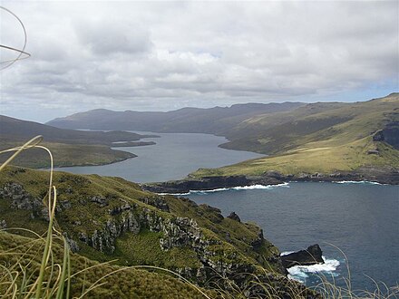
- Macquarie Island 📍, part of Tasmania in Australia, is a wildlife reserve 20 miles long by 3 miles wide.
- Heard Island and McDonald Islands 📍 are a territory of Australia, with that nation's only active volcanoes, last erupting in 2016. It's also a
- Kerguelen 📍 is part of the French Southern and Antarctic Lands territory. The main island Grande Terre is 90 miles east-west by 70 miles north-south and has a permanent scientific settlement. There are some 300 lesser isles in the archipelago.
- Crozet Islands 📍 are a French archipelago, with the research station Alfred Faure on Île de la Possession.
- Prince Edward Islands 📍 are part of South Africa, 1200 miles southeast of the Cape, with Marion Island the larger and Prince Edward the smaller island.
- Bouvet Island 📍 is Norwegian, ice-clad, and volcanic though with no recent eruptions.
- South Sandwich Islands 📍 are administered by Britain together with South Georgia. They're volcanic and stretch almost to the 60th parallel, so they're on the threshold of Antarctica and are the most difficult to access of all the Subantarctic islands.
- South Georgia Island 📍 is an icy, mountainous British island, with the old whaling stations of Grytviken and South Leith.
- Falkland Islands 📍 are a British overseas territory where the 3000-odd people are heavily outnumbered by sheep and penguins.
- Tierra del Fuego 📍 is an archipelago at the tip of mainland South America. Its eastern section with the city of Río Grande and port of Ushuaia is in Argentina, and the larger, wilder western section is in Chile. Further north, other islands dot Chile's fjord coastline for hundreds of miles up into warmer latitudes.
Get in
It's not too difficult for those islands near a regular cruise route to Antarctica and with a harbour or at least a sheltered beach that a Rib / Zodiac can access. These are routinely visited by cruises in summer: see Antarctica#Get in for options. Cruises from Ushuaia in Tierra del Fuego towards the Antarctic Peninsula often take in South Georgia, and those from New Zealand towards the Ross Sea might take in the NZ Group or Macquarie.
At the other end of the scale, islands far from a cruise route and lacking harbours are very challenging to reach, and then there's the getting out to consider. Bouvet Island is one bleak and daunting example. Some of these places have only been reached by a handful of people in the 250 years since they were discovered.
Midpoint on the scale of difficulty is Kerguelen. Tourists may visit on the regular supply ship from Réunion, which makes a one-month circuit of the heaving ocean and also calls at Crozet and Amsterdam Island.
You may need official permission to land, or even to sail close to shore - this is chiefly to protect the wildlife. Cruise operators and expedition organisers are responsible for arranging this, and it may need to be sorted several months in advance.
Get around
The lack of development on these islands means that there are no roads or even any form of paths on most of them.
See
- No trees: subantarctic scenery lacks trees and shrubs, and resembles tundra. This means that birds (including penguins) nest on open ground, where they are vulnerable to rats or visitor disturbance. The islands have rocky outcrops and tussocky grasslands; there may be ice caps at high elevations, but not on low ground.
- Sea life includes seals and whales. They were once hunted commercially, and some islands have the rusty ruins of old whaling stations.
- Volcanoes are active on Heard Island and the McDonald Islands, and along the chain of South Sandwich Islands. Their active history is only partially known, as it's only in the 21st century that satellite imaging has spotted their belchings of steam and ash. Penguins are fond of volcanoes, as the geothermal warmth creates areas free of glaciers.
- Huge icebergs – defined as 20 km or more across – are common around Antarctica, and may last for decades, but most remain pinned within the pack ice. A few escape, and the largest may reach the Subantarctic islands and shipping lanes of these latitudes, so they're tracked by the US Ice Center. A good example was A68a, which in 2021 approached South Georgia before breaking up. "A" means it calved in the quadrant between 0<sup>o</sup> and 90<sup>o</sup> West, the Bellingshausen and Weddell seas – in this case it was the Larsen Ice Shelf on the west coast of the Peninsula. B-icebergs are from the quadrant 90<sup>o</sup> to 180<sup>o</sup> West, and so on round. A68 means it was the 68th iceberg from Quadrant A, and when it broke into pieces that were huge in their own right, these were labelled A68b, c, d etc, with the mother-berg being A68a. Its end was unexpected: it didn't gradually fracture, but suddenly foamed and fizzed away like a colossal Alkaseltzer. Probably day-time melt water permeated it to freeze and expand at night, pushing open the cracks for the next day's melt water, until there was massive structural failure. So A68a has given us insight into how other ice blocks might suddenly destabilise.
- Iceberg A76a 📍 (as at 10 March 2023) is the largest now in play, extending some 136 km by 35 km. It was bigger than Mallorca when it calved from the Filchner–Ronne Ice Shelf, then broke into three and is drifting towards the Shag Rocks off South Georgia Island.
Do
These little-explored islands are quiet places with little or no population, so hiking is really your only option.
Buy, eat, and drink
You must bring everything you need with you and take everything away, especially trash.
There may be fresh water sources in summer, but the birds will get there first and may foul it.
Stay safe
Weather
The environment is extreme, with latitudes called the roaring forties, filthy fifties and screaming sixties for good reason. Storms sweeping off Antarctica, unobstructed by any land, bring cold strong winds, rain or snow and rough seas to the region. This part of the world is the preserve of deep sea fishing ships (not boats), warships on fisheries patrols, oceanographic research ships, round-the-world yachts and the occasional icebreaker on its way to Antarctica. If you get into trouble, you must be prepared to rescue yourself, as emergency rescue services may be thousands of miles and several days away.