The Trans-Siberian Highway is the unofficial name for a network of federal highways which span Russia cross-country from Saint Petersburg to Vladivostok; a small section of the route passes through the northern edge of Kazakhstan.
Understand
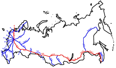 The Trans-Siberian Highway is a network of seven federal highways which span over 11,000 km (6,800 mi) of Russia, from Saint Petersburg on the Baltic Sea (Atlantic Ocean) to Vladivostok on the Sea of Japan (Pacific Ocean). Much of the route parallels that of the earlier Trans-Siberian Railway. A large portion is numbered as part of Asian Highway Network route AH6, in many places also coinciding with European route E30.
The Trans-Siberian Highway is one of the world's longest national highways, although Australia's Highway 1 continental ring road is longer.
Prepare
To temporarily import a vehicle, one should bring a driving licence (international driving licence recommended, not mandatory), vehicle registration documents (and, if the driver is not the registered owner, a letter of attorney), customs declaration forms (submit one copy on entry and the other when leaving the country) and a "green card" indicating the vehicle has insurance which is valid in Russia.
Vehicles with studded tires must display a warning sticker (a 'ш' in a red triangle). A separate sticker must state the nationality of the vehicle. See Driving in Russia for more details.
Get in
Saint Petersburg is a few days' to one week's drive away from most parts of Europe and there are multiple ways in. For instance you can drive to Poland and take the Via Baltica up to Latvia or Estonia and from there on to Saint Petersburg. Alternatively you can get to Finland by taking the ferry from Germany or Sweden and drive along the European route E18. If flying in, there are direct flights from Saint Petersburg from most major airports in Europe, as well as some flights from elsewhere in the world.
Vladivostok is served by ferries from South Korea and Japan. You can also drive in from China and possibly North Korea. You can get in by plane from elsewhere in Russia and larger East Asian destinations.
Drive
This itinerary is listed from west to east, beginning in St. Petersburg and ending 11,000 kilometres (6,800 mi) later in Vladivostok. The trip may be made in either direction. (In some cases, two numbers are listed for the same road as the old M-series numbers for all but the largest highways were replaced with R-series numbers, which may display as P-series if written in Cyrillic text. The old numbers were removed in 2017.)
Saint Petersburg to Moscow
 Saint Petersburg 📍 (pop 5 million) is the second largest city and former capital of the Russian Empire. From Saint Petersburg's Pushkinsky District, the M10 (Russia Highway) runs 664 kilometres (413 mi) south through Novgorod 📍, Tver 📍, Klin 📍 and Khimki 📍 to Moscow.
Moscow to Chelyabinsk
Moscow 📍 is the capital of Russia and of the former Soviet Union. From here, the M5 (Ural Highway) runs for 1,880 kilometres (1,170 mi) east through Kolomna 📍, Ryazan 📍, Penza 📍, Ulyanovsk Oblast, Samara 📍, Orenburg Oblast, Tatarstan and Ufa 📍 to Chelyabinsk.
Chelyabinsk to Novosibirsk
From Chelyabinsk 📍, the M51 (Russian route R254, Irtysh Highway) runs 1,528 kilometres (949 mi) eastward through Russia and Kazakhstan. It runs from Chelyabinsk through Kurgan 📍, crosses through the Kazakhstani North near Petropavl and returns to Russia to reach Omsk 📍 and Novosibirsk.
(It is possible to bypass Kazakhstan – as the mainline Trans-Siberian Railway now does – but it requires a bit of a detour: exit at Makushino for Ishim, Tyumen Oblast then take Russian route R402 to Omsk, rejoining the Trans-Siberian there to continue to Novosibirsk.)
Novosibirsk to Irkutsk
From Novosibirsk 📍 the M53 (R255, Siberia Highway) continues 1,860 kilometres (1,160 mi) through Tomsk 📍, Kemerovo 📍, Krasnoyarsk 📍 and Tayshet 📍 to Irkutsk.
Irkutsk to Chita
From Irkutsk 📍, Russian route M55 (R258, Baikal Highway) runs 1,113 kilometres (692 mi) through Ulan-Ude 📍 to Chita. You will have to go around Lake Baikal at this point.
Chita to Khabarovsk
 From Chita 📍, the M58 (R297, Amur Highway) 2,100 kilometres (1,300 mi) east to Belogorsk 📍, Blagoveshchensk 📍 and Khabarovsk was the last section completed; it was fully paved by 2010. Before the construction of this highway, the only east-west route through central Siberia's roadless 400 mile (640 km) Zilov Gap was the Trans-Siberian Railway.
Khabarovsk to Vladivostok
From Khabarovsk 📍 the M60 (A370, Ussuri Highway) covers the final 760 kilometres (470 mi) through Khabarovsk Krai, Ussuriysk 📍 and Artyom 📍. The highway ends at the Pacific seaport of Vladivostok 📍.
Stay safe
Traffic in Russia is unpredictable; expect to encounter dangerous overtaking and excessive speeds in urban areas. Roads and cars are often in dangerously bad condition. Police corruption is declining, but still exists; a dashcam is a necessity as evidence in a collision and as a defence against authority trouble. See the article on driving in Russia for details.
Go next
- A ferry (dead link: January 2023) runs from Donghae, South Korea to Vladivostok, continuing to Japan
- In the western end you have the rest of Europe ahead of you; Finland and Estonia are the nearest countries from St. Petersburg.