Valldal - valley in Norddal Municipality in Møre og Romsdal county, Norway
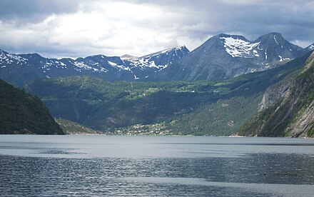
Valldal is the 30-kilometre-long valley going from the fjord in the south to the famous Trollstigen in the north. It is a fertile valley (known for strawberries and fruit) surrounded by alpine mountains. The valley is home to road 63 connecting Geiranger and Åndalsnes. The area sits on the northern shore of Norddalsfjorden-Tafjorden branch of Storfjorden and includes Tafjord village and valley as well as Fjørå village.
.jpg/440px-A_view_towards_Norddalsfjorden_near_Kilsti,_M%C3%B8re_og_Romsdal,_Norway,_2013_June_(cropped-2nd).jpg)
Understand
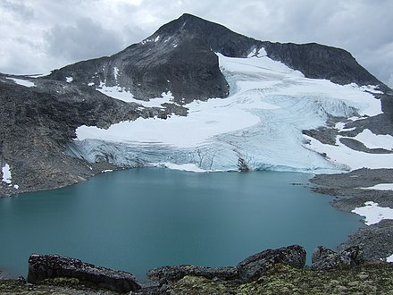
Valldal is in the south-east corner of Møre og Romsdal county in West Norway. The village Sylte at the Norddalsfjord (a branch of Storfjord) is the centre of this agricultural district. Norddalsfjord is the northern branch of Storfjord, while the more famous Geirangerfjord extends to the south. Valldal is the western border of the Reinheimen - Norway's youngest national park.
Valldal is surrounded by attractive alpine mountains and steep, green hills. A wild river runs through the valley creating several nice waterfalls, including Holsfossen (10 kilometres upstream), Gudbrandsjuvet (15 km upstream) and Skjerdsura (16 km upstream) - these waterfalls are next to the road.
Despite the northern latitude, Valldal has a mild climate and is famous for cherries, apples, raspberries, and strawberries produced on a commercial scale. The thick forests are home to a large number of red deer, roe deer and other wild animals. In the high mountains towards the east, rein deer and wolverine enjoy endless wilderness.
Road 63 through Valldal connects, Trollstigen and Geiranger, two of Norway's major attractions, to each other. Because of its natural beauty, involving both wild, alpine mountains, green fertile valleys and deep fjords, and impressive road constructions, the route was previously called the Golden Route. Now the stretch is named one of Norway's 18 National Tourist Route (dead link: January 2023). The Minister of transport inaugurated all of the 18 routes in a ceremony at iconic Trollstigen mountain pass.
From Sylte (Valldal village) there is a local road to Tafjord, a tiny village at the mouth of a wild, narrow valley. From Tafjord village the road leads to the 100-metre-high Zacahricasdammen, a concrete water dam in the extensive Tafjord hydro power production system. This is also the gateway to the network of paths and huts in the Tafjord mountains, the western part of Reinheimen national park.
Places
- Valldal village (aka Sylte)
- Valldal valley proper (from fjord to Trollstigen mountain pass)
- Fjørå village
- Tafjord village
Get in
By car
- Route 63 from Åndalsnes via Trollstigen (summer only, from mid May to November). Route 63 from Geiranger including short ferry at Eidsdal (all year) and Skjåk/Stryn via Geiranger mountain pass (summer only).
- Route 650 from Sjøholt, connected to E39 from Ålesund (west) and Molde (north). Route 650 connects to route 60 via ferry at Stranda, route 60 allows all-year access from Stryn, Førde, Sogndal and Bergen.
By boat
Ferry service from Valldal to Geiranger has been discontinued.
By bus
 To Valldal there are buses from
- Ålesund
- Geiranger
- Åndalsnes (summer only)
- Hellesylt/Stranda few times every day.
By rail
The Rauma railway terminates at Åndalsnes the closest and only railway in the area, about 50 km from Valldal, transfer from Åndalsnes via Trollstigen mountain pass (summer only).
- Rauma railway terminal station, Åndalsnes, 62.567°, 7.690°. Terminal station of the scenic Rauma line, a fine piece of railway engineering. Connectios to Trondheim and Oslo via Dombås junction.
By air
There is no airport, closest airports:
- Ålesund Airport, Vigra, 62.558°, 6.114°.
- Molde Airport, 62.7465°, 7.2596°.
- Ørsta/Volda Airport, 62.180°, 6.080°.
Get around
There is one road (route 63) running through the valley. There are few buses every day from Valldal via Trollstigen to Åndalsens. It is possible to get around by bus but relatively time consuming and gives no freedom stop at nice and interesting places. A car or bicycle gives the best opportunity to travel your own way.
There are a couple of taxis in the valley. Unless you are in the village, you must order the taxi by phone and be prepared to wait for it.
See

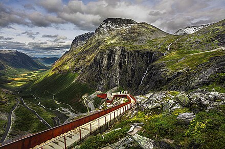
- Trollstigen mountain pass, 62.4549°, 7.6656°. summer only (late May - October). The Trollstigen, a mountain road climbing the pass between Isterdalen valley in the North and Valldal valley in the South. This iconic road is the major attraction in this area and one of the most visited destinations in Norway. It is a elegant road and engineering achievement amidst iconic mountains and wild waterfalls. Part of road 63 between Åndalsnes and Geiranger, designated as one of Norway's national tourist routes. During high season the traffic load is high at noon (11 to 14 o'clock), traffic jams occur, try to drive early morning or evening. Free
- "The snake" - a geological formation in the cliffs above Valldal village (Sylte).
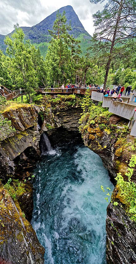
- Gudbrandsjuvet gorge, Road 63 (15 km from Valldal), 62.3307°, 7.4695°. All day, all year. The gorge and waterfall at Gudbrandsjuvet (15 kilometers upstream). The dry stone bridge across the gorge constructed in the 1920s as part of the Valldal-Åndalsnes road is still in use. The main river runs through a narrow (5 metres) and deep (25 metres) gorge, in fact a series of large "giant's kettle". The gorge is so narrow and complex that it is hard to see all even if the road runs across and there is an elaborate system of viewing platforms for visitors. Lovely rapids/waterfalls at Skjerdsura (boulders) just north of Gudbrandsjuvet along the road. According to the Sagas, king Olaf the Saint built the first road through the Skjerdsura boulders in year 1028. Free
- Zacharias dam, Tafjord (Road uphill from Tafjord (car needed).), 62.2011°, 7.4905°. All day, all year.. The Zacahrias dam in Tafjord is a 95-metre-high concrete dam in a narrow river gorge. The main reservoir for the Tafjord hydro power complex. Grand nature. Free.
- Holsfossen (waterfall and bridge), 62.337°, 7.388°. In Holsfossen (waterfall 10 km from fjord) next to the road there is a tiny power station that has been reopened after being closed for 50 years. Free
- Tafjord power station and museum, 62.226836057°, 7.4232816696°. 11:00 to 17:00 (summer). Tafjord power plant, first power station built 1920s, now a museum. Free
- Muldalsfossen, Road 92 (Drive towards Tafjord, hike.), 62.2513°, 7.4349°. 24 hour. Muldalsfossen (waterfall) is a strange waterfall on the road between Tafjord and Valldal. The waterfall is hidden in a steep gorge and exit height is not known, about 200 m. Best viewed from the abandoned farm on the shelf (about 1 hour hike uphill). Be extremely careful on the slopes around the waterfall, fatal accidents have happened. Free
Do


- Valldal Naturopplevingar, 62.2972°, 7.2629°. Offers a variety of outdoor activities like whitewater rafting in the river Valldøla (4 hour trip 790 kr), Canyoning (4 hour 790 kr), Sea kayak and SUP rental (from 300 kr). They are located in the center of the village. Phone +47 900 14 035
- Hike to or around numerous charming "sæters" (outfarms), scramble the hills to summits for a spectacular panorama, try fishing in the fjord. Salmon fishing in the river is reserved for owners, but permission to fish for a specific period can be purchased at the tourist information office. Valldal and nearby Tafjord are starting points for the network of trails and lodges in the Tafjord mountains.
- Walk the small road to Muldalen and visit the abandoned farms at the shelf overlooking the spectacular Muldalsfossen. The small road starts close to the small bridge after the 5 kilometer tunnel on the road from Valldal to Tafjord.
- See the great fjord from the mountain top at nearby Stranda via the Stranda gondola lift.
- Drive one of the smaller roads up hill sides to get the best panorama. Lingeåsen (at Valldal village), Selboskar/Hauge (at Fjørå), Kilsti (at Eidsdal across the fjord) and Lilleås/Hatlestad (at Norddal across the fjord) offers effortless panoramas.
Buy
You can buy hand- and homemade jam and juice at the local shop, Norsk Baerindustri, which you can find in the street at the backside of the church. It has a healthy selection of jams and juices, pressed and simmered in the small factory behind the shop and sourced in the main from local farmers.
Eat
Try locally produced strawberries, raspberries, sweet cherries, apples and other fruits available from mid summer to September.
Drink
Sleep
.jpg/440px-Valldal_(1).jpg) Although many tourists rush to world-famous Geiranger, neighbors like Valldal offers inexpensive accommodation a short trip from the crowded and narrow Geiranger village.
Although many tourists rush to world-famous Geiranger, neighbors like Valldal offers inexpensive accommodation a short trip from the crowded and narrow Geiranger village.
Valldal is dominated by camping and caravans. A large number of cabins ("hytter") are available along the main road
- Fjellro Turisthotell, +47 70 25 75 13, fjellro@realtime.no. The only hotel in Valldal village
- Gjerde Camping, +47 70 25 79 61, gjcamp@online.no.
- Juvet Landscape Hotel (Juvet Hotell), Gudbrandsjuvet in Valldal (Road 63, 13 km from Valldal village, 30 from Åndalsnes). This unsual hotel is situated at the Gudbrandsjuvet gorge, close to road 63 Trollstigen-Geiranger, yet peaceful and hidden from the rush along the road.
- Valldal Hytter & Fritid, +47 901 01 143, kaia@kragebakk.no.
Connect
The tourist information office in Valldal is in the village close to the marina.
Go next
- Geiranger by bus or car via ferry at Linge.

- By car: roads to Geiranger (short ferry at Linge), Ålesund and Åndalsnes via Trollstigen.
- Visit Åndalsnes via the Trollstigen. Trollstigen ("The Troll Pathway") is a mountain road and national scenic route on highway 63 between Åndalsnes and Valldal in West Norway. It is one of Norway's major attractions due to its steep incline and eleven hairpin bends climbing cliffs and steep hills until the mountain pass. Trollstigen is closed during the fall and winter months. A normal opening season stretches from the mid of May to October.
- Ålesund or Molde by bus or car.
Valldal
Timezone:MultipleCoordinates:62.33, 7.38

