Cairngorms National Park - national park in Scotland, United Kingdom
The Cairngorms, by far the largest national park in Scotland and the United Kingdom, spans the mountains between the Highlands region and Aberdeenshire, plus smaller areas of Angus, Perth and Kinross, and Moray. The park takes its name from the Cairn Gorm or "Blue Mountain" and surrounding peaks and plateaux, but it also includes the Monadhliath & Grampian ranges to the east, the Angus Glens, and the upper valleys of the Spey, Dee and Tay.
The park has no entry fees or gates. Permits may be required for activities such as fishing, and there are various commercially-run activities such as skiing and pony-trekking. But most of what the park has to offer is free, not least the scenery.
Most accommodation, eating and similar facilities are in the small towns listed below, especially Aviemore. This page describes facilities that range across the park, or that aren't close to any settlement.
Understand
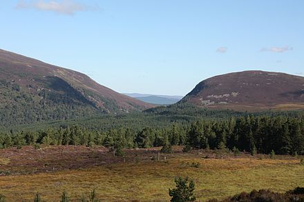
The Cairngorms are essentially a huge block of granite. During the Ice Age, the ice sat on top but didn't move. Elsewhere in Britain (e.g. in the English Lake District) it carved out U-shaped valleys and other distinctive glacial features; here, with the exception of a few narrow valleys such as Lairig Ghru, it just polished the block into a series of rounded tops of similar height. So what was left behind was a plateau at 1000-1200 m altitude, with the peaks of Ben Macdui (1309 m), Braeriach (1296 m), Cairn Toul (1291 m) and Cairn Gorm (1244 m).
This creates a habitat for hardy plants and animals that are common in sub-arctic countries but rare in Britain. It's too cold, stony and steep for agriculture, and the Caledonian forests in the valleys represent the last stand of the primeval forest that once cloaked Scotland. Modern times have seen encroachment by sheep-farming, game hunting and forestry, and climate change has become appreciated as a threat. The area was therefore protected in 2003 by designation as a national park. It's a remarkable wilderness, interspersed by lochs, rivers, woodland and moors. Wildlife includes crossbills, ospreys, capercaillie, golden eagles, red deer, red squirrels, otters, and mountain hare. Highlights include:
- the Eurasian beaver (Castor fiber), with some 500 now inhabiting the Tay valley; likeliest sightings are May-Aug at Loch of the Lowes above Dunkeld.
- a free-roaming herd of reindeer (Rangifer tarandus), about 150 between Cairngorm and Glenlivet; usually just a distant smudge on the moor, but they may come snuffling up for hand-outs.
- you will be very lucky to spot the Scottish wildcat (Felis silvestris silvestris), or be sure that it's not just a burly domestic cat - they interbreed enthusiastically and there may be only a few dozen "pure" wildcats out there.
Room for any more? As the UK's largest park, with an area of 4,528 km<sup>2</sup> (1,748 sq mi), the Cairngorms may be suitable for re-introduction of long-extinct species such as lynx, wolves, and even bears. But this has to be balanced against its IUCN designation as a "Category 5" area, where farming and commercial activity are permitted, and tourism is encouraged, within sustainable limits. The family picnic remains safe for now.
Towns
The main service town and access point for the western, larger side of the park is Aviemore 📍, which straggles into Coylumbridge.
Other small settlements along or near the main road A9 are Blair Atholl 📍, Dalwhinnie, Laggan, Newtonmore, Kingussie 📍 and Carrbridge 📍.
Going down the Spey Valley east from Aviemore are Boat of Garten, Dulnain Bridge and Grantown on Spey 📍.
The east side of the park, mostly in Aberdeenshire, is smaller and has fewer facilities, and most visitors come on day-trips.
Small places along the Dee valley are Ballater and Braemar 📍.
Get in
By plane
Inverness and Aberdeen are the closest airports, with connections across Europe and the UK. Edinburgh is a longer drive but has more flights, and is west of the city so you drive straight out onto M90 then A9.
By train
The railway line on the west (Tay & Spey) side of the park has trains between Edinburgh & Glasgow via Perth to Inverness every hour or two, plus the Highland Sleeper running overnight from London Euston to Inverness. Stations along the way (with not all trains stopping) are Dunkeld & Birnam, Pitlochry, Blair Atholl, Dalwhinnie, Newtonmore, Kingussie, Aviemore and Carrbridge.
The railway to the east hugs the coast from Dundee to Aberdeen, and is always at least 30 miles from the park boundaries. Trains also run from Aberdeen to Elgin, Nairn and Inverness, but it's even less convenient to access the park from that direction.
By bus
The Edinburgh-Inverness route operated by Scottish CityLink goes through the park along the A9.
By car
The A9 from Perth to Inverness enters the park in the south and follows along the western side of it to the north east of the park.
Follow the A93 from Aberdeen to enter the park from the east.
Get around
By bus
Stagecoach operates a few local buses. It is best to plan your journey in advance with Traveline Scotland.
By bicycle
The National Route 7 passes through the national park roughly following along the A9.
See
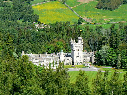
- Balmoral Castle, Balmoral Estates, Ballater AB35 5T (off A93 midway between Ballater and Braemar), 57.039722°, -3.231389°. April-July daily 10:00-17:00, occasional guided tours in winter.. Prince Albert, Queen Victoria's husband, bought this land and built a grandiloquent pile of a castle, the prototype of the "Scottish Baronial" style, all mock-turrets and stags heads looming over the stairways. Completed in 1856, it remains the Royal Family's summer holiday home. You can only visit one room within the castle, the ballroom, plus an exhibition in the stables, and the gardens. Prior to her death in 2022, Queen Elizabeth II usually resided here in Aug & Sept, at which times public access was restricted. See website for dates of guided tours in winter. Adult £11.50 2018-11-01
- Dalwhinnie Distillery, 56.940128°, -4.238061°. Open all year. The highest whisky distillery in Scotland. You can visit the distillery by tour.
- RZSS Highland Wildlife Park, 57.1111°, -3.97472°, +44 1540 651270. Safari park and zoo. 2017-04-02
Do
Mountain biking, canoeing, climbing, walking, horse-riding, sailing, skiing, snowboarding, golf, clay pigeon shooting, canyoning, gorge walking, orienteering, yoga, shinty, wildlife and birdwatching, tennis, swimming, white water rafting, river tubing, archery, fishing.
Walking:

- Cateran Trail. 103 km circular hiking route. 2017-04-18
- Abernethy Forest, 57.243°, -3.660°. A large forest (4,000 hectares) originating from the ancient Caledonian Forest. The forest is part of a larger National Nature Reserve and is great for wildlife spotting. The main entrance points are near Loch Garten in the west and near Nethy Bridge in the north. 2017-07-29
- Cairngorm Mountain (Cairn Gorm). A popular hike beginning at the Cairngorm Mountain ski centre. Ascend the rocky hillside to see tinkling brooks, nesting birds, and staggering views of the surrounding mountains (as long as clouds aren't blocking the view). There are several trails to the top, some more popular than others; the Windy Ridge path is recommended as it mostly avoids walking close to the funicular railway and associated structures. On the peak you'll find a large cairn and an automated weather station. If you get to the peak and the view is hidden by clouds, never fear – the clouds may dissipate in a few minutes, and if not, nearby side trails lead to lower vantage points with worthwhile views of their own. If you have the energy, it's possible to combine the summits of Cairngorm and Ben Macdui on a single loop. 2021-07-08
- Ben Macdui. For serious hikers, the summit of Ben Macdui, the second-highest mountain in the British Isles, can be reached on a 17-km loop beginning at the Cairngorm Mountain ski centre. This may be tricky if you don't have a car, as it will be hard to make it back to the ski centre in time for the last bus back to Aviemore. 2021-07-08
- Loch An Eilein. A tranquil loch reachable by a trail from Aviemore's Rothiemurchus neighbourhood. Bring a map or download an OpenStreetMap-based app like OsmAnd or Mapy.cz to help you navigate. Turn left just before Lochan Mor (the turn is slightly hard to spot, but if you miss it the other trail will also go to Loch An Eilein). You may see deer on the way, especially if you set off early before the other walkers have scared them away. It takes about an hour to walk to Loch An Eilein from Aviemore, and the loch is also reachable by car if you prefer. There is another path circling the loch, which may take about two and a half hours to complete. This path is popular with dog walkers and mountain bikers, and is reasonably flat and not too challenging. In the middle of the loch is a small island with the remains of a castle. If you decide to walk around the loch, take one of the side trails that say "Path not maintained" to get to Loch Gamhna, which is somehow even more peaceful than Loch An Eilein itself. In spring and summer, keep an eye out for ducks with ducklings. 2021-07-08
- Ord Ban. A 400-m hill near Loch An Eilein, a worthwhile hike with rewarding views. Compared to the path around the loch, this trail is much quieter, somewhat more challenging, and less maintained. Make sure to wear long trousers because your legs may be seen as an invitation for dozens of tiny ticks, and wear good footwear because part of the trail is very muddy. The vegetation changes dramatically near the top of the hill, and the peak has views of the nearby landscape. If desired, this walk can be done in a loop that goes back to the loch. 2021-07-08
Mountain biking:
- Laggan Wolftrax, 57.00075°, -4.31689°, +44 1479 861220. A network of purpose-built mountain bike trails, with a café, shop and bike hire.
Skiing: there are three downhill skiing facilities within the park:
- Cairngorm Mountain, PH22 1RB (15 miles east of Aviemore, Stagecoach Bus 31 runs every 30 min), 57.13372°, -3.67028°, +44 1479 861261. The funicular, has been closed since Oct 2018 because of damage to the track supports, and the managing company went bankrupt. Future plans for the resort are unclear. 2019-05-13
- Glenshee Ski Centre, Cairnwell, Braemar, Aberdeenshire, AB35 5XU (on the A93, 15 km south of Braemar), 56.88680°, -3.41569°, +44 13397 41320. 2017-07-30
- The Lecht 2090, Strathdon, Aberdeenshire, AB36 8YP (on the A939, 30 km northeast of Ballater), 57.20106°, -3.24798°, +44 1975 651440. 2017-07-30
Buy
Eat
And see individual towns listed above.
- Gordon's Tearoom and Restaurant, Mar Rd, Braemar, +44 1339 741611. 2017-04-18
Drink
- Goodbrand & Ross tea room, Corgarff, Strathdon, 57.162395°, -3.185195°, +44 1975 651433. 2017-04-18
Sleep
And see individual towns listed above.
There are plenty of guest houses, self-catering cottages and hotels throughout the park, and a couple of Caravan & Camping parks.
- Glen Clova Hotel, Glenclova, 56.844388°, -3.104161°, +44 1575 550350. Offers dog-friendly hotel rooms, lodges, and shared sleeping spaces (bunkhouses). The bunkhouse has washrooms and a full kitchen; bring your own towels and soap. Some accommodation packages include breakfast, use the website's check availability feature to see what packages are available. Also has a restaurant and bar that has a pet friendly section. You can get a packed lunch here. Average prices are £20 per person per night for bunkhouse stays, £110 per night for hotel rooms, £550 for a few nights stay in a luxury lodge 2017-04-18
Camping
- Spey Bridge Caravan & Camping Park, Perth Rd, Newtonmore, 57.056784°, -4.129997°, +44 1540 673275. 2017-04-18
Backcountry
You can camp out in the wilderness if you are in a small group for a couple of nights, although you must stay away from houses and not disturb any livestock.
Stay safe
Check the Mountain Weather Information Service (MWIS) for Scotland before going hiking in the mountains.
In an emergency, dial 999 or 112 and ask for "police, mountain rescue".
Go next
- Rannoch Moor
- Loch Lomond and The Trossachs National Park — Scotland's first National Park
Cairngorms National Park
cairngorms.co.ukAberdeenshire
2nd-order administrative division
Scotland
Primary administrative division