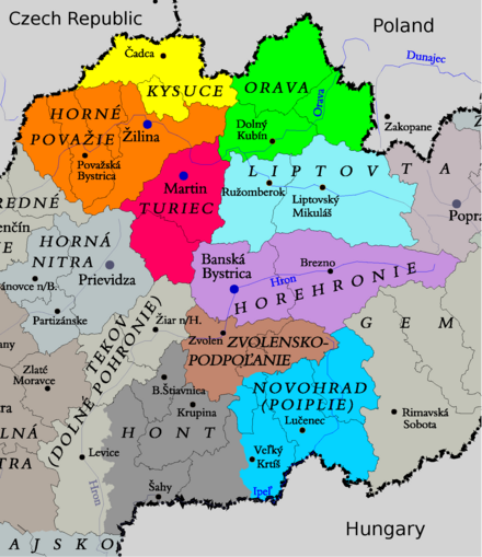
Central Slovakia - region in Slovakia
Central Slovakia is bounded by the Czech Republic and Poland to the north, and Hungary to the south.
Regions

Kysuce (Čadca, Kysucké Nové Mesto, Krásno nad Kysucou)
Historically one of the poorer regions, it's recovering thanks to car manufacturing, ski and cross-country possibilities.
Horné Považie (Bytča, Čičmany, Rajec, Papradno, Púchov, Rajecké Teplice, Žilina)
Beautiful countryside.
Orava (Dolný Kubín, Námestovo, Terchová, Trstená, Tvrdošín)
Orava castle and nature.
Turiec (Martin, Turčianske Teplice)
Surrounded by mountains with many hiking and skiing possibilities. Mineral springs spa also in Turčianske Teplice. National cultural center in Martin.
Liptov (Liptovský Hrádok, Liptovský Mikuláš, Ružomberok)
One of the most visited regions, thanks to a plethora of natural and historical sites. Hiking, skiing, water activities, caves, castles - it's all there.
Horehronie (Banská Bystrica, Brezno)
National parks, caves, skiing and spas.
Hont (Banská Štiavnica, Pukanec)
Contains multiple castles (in Čabradský Vrbovok, Bzovík), mineral water pools in Dudince and others.
Novohrad (Lučenec, Veľký Krtíš)
Volcanic mountain ranges, mining towns, castle ruins.
Cities
- Banská Bystrica, 48.74°, 19.14°. was one of the most important mining towns of Hungarian part of Austro-Hungarian Empire; beautiful restored square, many churches, castles and museums and memorial of the Slovak National Uprising 2016-11-05
- Banská Štiavnica, 48.46°, 18.91°. This medieval mining town in central Slovakia is a UNESCO World Heritage site 2016-11-05
- Dolný Kubín, 49.217°, 19.293°. Orava castle, skiing in the nearby mountains. 2016-11-05
- Púchov, 49.121°, 18.324°. Very peaceful spa town surrounded by magnificent Mala Fatra National Park 2016-11-05
- Liptovský Mikuláš, 49.085°, 19.613°. Historical centre of Liptov, it is located between High Tatras and Low Tatras, near the Liptovská Mara dam. 2019-03-05
- Rajecké Teplice, 49.128°, 18.680°. Spa area. 2016-11-05
- Ružomberok, 49.082°, 19.304°. On the first sight an industrial city, providing plethora of hiking and relaxation possibilities; includes the UNESCO-listed folk village of Vlkolínec 📍. 2016-11-05
- Žilina, 49.223°, 18.737°. Fourth biggest city with a well preserved historical city centre influenced by German architecture and unique museum of the tinker´s culture located at the Budatín castle 2016-11-05
- Zvolen, 48.575°, 19.133°. 2016-11-05
Other destinations
Understand
Get in
There are regular inter-city bus and train connections available, both to Bratislava/Košice and surrounding countries.
D1 and R1 highways connect most of the biggest cities, except the mountainous area between Žilina and Liptovský Mikuláš, where work is still ongoing. Traffic jams occur there in the rush hours (mostly Friday and Sundays afternoon).
Get around
See
- Likava castle ruins, 49.1052°, 19.3120°. 2016-11-05
- Liptov village museum, 49.1068°, 19.8045°. A reconstruction of a historical village destroyed while creating Liptovská Mara dam. 2016-11-05
- Modrý Kameň castle ruins, 48.243611°, 19.333056°. This 13th-century castle of gothic-renaissance style is placed in a town of the same name. Nowadays, a museum of dolls and toys can be visited here. 2017-12-28
- Orava castle, 49.2618°, 19.3585°. 2016-11-05
- Strečno castle, 49.1746°, 18.8625°. 2016-11-05
- SNP memorial, 48.7352°, 19.1497°. 2016-11-05
- Zvolen Castle (Zvolenský zámok), 48.57289°, 19.12724°. A castle standing on a low hill. Slovak National Gallery collections displayed. 2016-11-04
Do
The area is a great place to go hiking and skiing. Check e.g. Ružomberok or Liptovský Mikuláš.
Mountain ranges:
- Choč Mountains, 49.152°, 19.343°. Pretty ravines and great overview from the top of the main mountain. 2016-11-05
- Great Fatra, 48.967°, 19.104°. 2016-11-05
- Little Fatra, 49.233°, 19.039°. Peaks like Veľký Rozsutec, or ravine Jánošíkove diery make this area very worth the day or two of stay. 2016-11-05
- Muranska planina National Park., 48.740°, 20.045°. 2016-11-05
- Oravská Magura, 49.299785°, 19.357541°. 2016-11-05 and Oravské Beskydy (Orava Beskids)
- Poľana, 48.637222°, 19.483889°. Many thousand years ago, this was one of the biggest Earth's strato-volcanoes, with diameter approx. 18km. Nowadays though, it's completely forested and suitable for easy hiking. 2016-11-05
- Low Tatras ("Nízke Tatry" / Národný Park Nízke Tatry), 48.94°, 19.61°. Skiing, multi-day hiking and caves. 2016-11-05
- Tatra National Park, 49.15°, 19.92°. Their most visited part is High Tatras ("Vysoké Tatry"). Great place for one-day hikes, relaxation and skiing. 2016-11-05
Eat
Drink
Stay safe
Go next
Central Slovakia
Timezone:MultipleCoordinates:48.76, 19.19