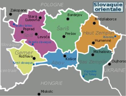
Eastern Slovakia - region in Slovakia
Eastern Slovakia is bounded by Poland to the north, Ukraine to the east, and Hungary to the south.
Regions
This region corresponds to the city of Košice and its surroundings. The places worth visiting are the caves of Jasov, World Heritage Site, Valley Zádiel, an impressive canyon carved in limestone rocks - or you can try a cure in the spa of Štós, which specializes in treating respiratory diseases. Many excursions are possible near Lake Ružín and in the Volovské Vrchy Mountains stretching west of Košice.
Near the town of Rožnava, is the Slovak Karst National Park, which many caves are part of world natural heritage. From an architectural standpoint, the castles of Betliar and Krásnohorské Podhradie are worth stopping.
The main town of the region is Prešov but the tourist point of view, it is the small town of Bardejov that is certainly the most attractive. In addition to its World Heritage Centre, the city is a great base for visiting some of the wooden churches spread around.
Spiš (Spišské Podhradie, Poprad, Kežmarok)
Old German colonization of land in the Middle Ages, we find several World Heritage sites around the small town of Spišské Podhradie and the town of Levoča. Also other localities as Spišská Sobota, Kežmarok are worth visiting. For nature lovers, there are 3 national parks: Slovak Paradise National Park is a paradise for hikers, the Tatra National Park, and the Pieniny National Park known for raft descents of the Dunajec makes the border with Poland.
The easternmost tourist region of Slovakia. It has a wooded landscape of low mountains, much of which is covered by the Poloniny National Park, which includes primary forests and is the only place where bisons live in the wild in Slovakia.
The region is dominated by the plain of the river Tisza. The water of rivers and flooded areas make it a paradise for birdwatchers. Wine lovers will have to make a visit to the cellar of the Slovak Tokaj vineyards.
Cities
- Bardejov, 49.29216°, 21.27580°. Bardejov — center of the Northern Saris region, well preserved town centre is in the UNESCO World Heritage List.
- Kežmarok, 49.13725°, 20.43122°. Historic Germanic city (Käsmark) known for its baroque church and castle at the feet of High Tatras.
- Košice, 48.72132°, 21.25683°. The main town with about 250 000 inhabitants. Metropolis of eastern Slovakia, the second largest city in the country with the easternmost Gothic cathedral of the European continent, the oldest in Europe armories assigned to a city, a historic center with the complex of the Cathedral, numerous churches, palaces and museums.
- Levoča, 49.02616°, 20.58872°. A well-preserved city center on the list of UNESCO World Heritage list
- Michalovce, 48.7557°, 21.9184°. The second largest city in The Kosice Region and the gateway to the Vihorlat Mountains and Zemplinska Sirava, Slovakia's largest artificial lake providing for many recreational opportunities.
- Poprad, 49.05486°, 20.30128°. At the feet of Tatra National Park, it's the entrance to High Tatras
- Prešov, 48.99790°, 21.24138°. Good example of renaissance architecture in Slovakia, numerous churches and a nearby Solivar - one of the most interesting salt mine museums in Europe
- Spišská Nová Ves, 48.94336°, 20.56898°. Entrance to Slovak Paradise National Park.
- Ždiar, 49.27072°, 20.26540°. A town in Tatras, with original folk traditions and ethnographic museum.
Other destinations
- Tatra National Park, 49.180278°, 19.919444°. Hiking in the summer is the main activity. Carpathian mountains are accessible by well marked trails or with mountain guides.
- Pieniny National Park, 49.4°, 20.416666°.
- Poloniny National Park, 49.05°, 22.43°. One of the few places in Europe where flee wolves (Canis Lupus), brown bears, lynx and bisons live.
- Slovak Karst National Park, 48.6°, 20.519444°.
- Slovak Paradise National Park, 48.908333°, 20.4°.
- Slovak Tokaj vineyards, 48.42738°, 21.69697°.
Understand
Get in
Get around
See
Do
Eat
Drink
Stay safe
Go next
Central Slovakia | Poland | Ukraine | Hungary
