Voyages of James Cook
Voyages of James Cook
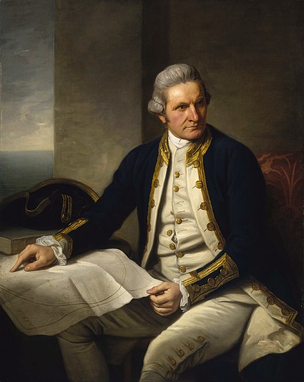 Captain James Cook was a British explorer, navigator, cartographer, and captain in the Royal Navy.
Understand
Youth
Born in 1728 in the village of Marton in North Yorkshire, when he was 16 (1745) Cook moved to the fishing village of Staithes, to be apprenticed as a shop boy. After 18 months, not proving suited for shop work, Cook travelled to the nearby port town of Whitby and was introduced to John and Henry Walker, who were Quakers, and prominent local ship-owners in the coal trade. Their house is now the Captain Cook Memorial Museum. Cook was taken on as a merchant navy apprentice in their small fleet of vessels, plying coal along the English coast. His first assignment was aboard the collier Freelove, and he spent several years on this and various other coasters, sailing between the Tyne and London. As part of his apprenticeship, Cook applied himself to the study of algebra, geometry, trigonometry, navigation and astronomy—all skills he would need one day to command his own ship.
Royal Navy and First Voyage
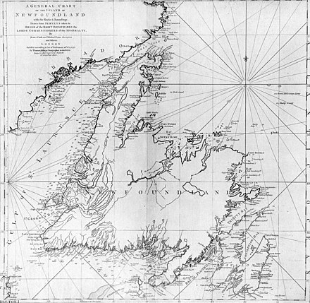
He joined the Royal Navy in 1755, and saw action in the Seven Years' War (1756 - 1763), surveying and mapping much of the entrance to the Saint Lawrence River during the siege of Quebec City, which fell to the British on 13 September 1759. This brought him to the attention of the Admiralty and Royal Society, which led to his commission in 1766 as commander of HM Bark Endeavour for a scientific expedition, his first voyage (1768–1771) to the Pacific Ocean, to observe and record the 1769 transit of Venus across the Sun from Tahiti. This data, when combined with observations from other places, would help to determine the distance of the Earth from the Sun. Cook, at age 39, was promoted to lieutenant to grant him sufficient status to take the command. For its part, the Royal Society agreed that Cook would receive a one hundred guinea gratuity in addition to his Naval pay.
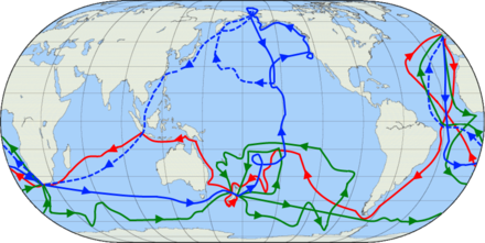
The expedition departed England on 26 August 1768, rounded Cape Horn and continued westward across the Pacific, arriving at Tahiti on 13 April 1769, where the observations of the Venus Transit were made, proving not as conclusive or accurate as had been hoped. Once these were completed, Cook opened the sealed orders from the Admiralty for the second part of his voyage: to search the south Pacific for signs of the postulated rich southern continent of Terra Australis. Cook then made the first recorded circumnavigation of New Zealand. Having aboard Tupaia, an exceptionally accomplished Tahitian aristocrat and priest, who helped guide him through the Polynesian islands, he mapped the complete coastline, making only some minor errors. Next, he sailed west for the first recorded European contact and waypoint naming on the eastern coastline of Australia, famously starting on 29 April 1770 with Botany Bay, named after the many first unique specimens retrieved by the botanists Joseph Banks and Daniel Solander.
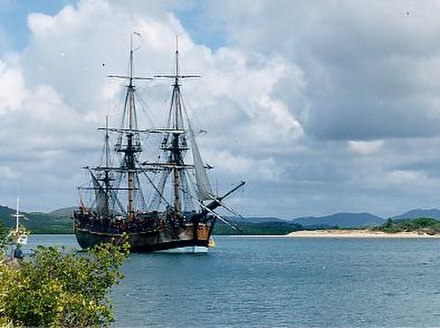 On 22 August 1770, Endeavour reached the northernmost tip of the coast and, without disembarking, Cook named it Cape York. Leaving the east coast, Endeavour turned west and nursed her way through the dangerously shallow waters of Torres Strait. Searching for a vantage point, Cook saw a steep hill on a nearby island, from the top of which he hoped to see "a passage into the Indian Seas". He disembarked, named the island "Possession Island", and claimed the entire coastline that he had just explored for the British crown, naming it New South Wales. He returned to England via Batavia, where many in his crew succumbed to malaria, the Cape of Good Hope, the island of Saint Helena on 30 April 1771, and anchored at The Downs on 12 July 1771. Cook's journals were published upon his return, and he became something of a hero among the scientific community. However, the aristocratic botanist Joseph Banks was a greater hero among the general public, and even attempted to take command of Cook's second voyage, but removed himself from it before it began.
Second Voyage
 From 1772 to 1775, on the ships HMS Resolution and HMS Adventure, commissioned by the British government with advice from the Royal Society, he went to circumnavigate the globe as far south as possible to finally determine whether there was any great Terra Australis. On 17 January 1773, Resolution was the first ship to venture south of the Antarctic Circle, which she did twice more on this voyage. The final such crossing, on 3 February 1774, was to be the most southerly penetration, reaching latitude 71°10′ S at longitude 106°54′ W. Cook almost encountered the mainland of Antarctica, but turned towards Tahiti to resupply his ship. He then resumed his southward course in a second fruitless attempt to find the supposed continent. On this leg of the voyage, he brought a young Tahitian named Omai, who proved to be somewhat less knowledgeable about the Pacific than Tupaia had been on the first voyage. On his return voyage to New Zealand in 1774, Cook landed at the Friendly Islands, Easter Island, Norfolk Island, New Caledonia, and Vanuatu. Before returning to England, Cook made a final sweep across the South Atlantic from Cape Horn and surveyed, mapped, and took possession for Britain of South Georgia, which had been explored by the English merchant Anthony de la Roché in 1675. Cook also discovered and named Clerke Rocks and the South Sandwich Islands ("Sandwich Land"). He then turned north to South Africa, and from there continued back to England. His reports upon his return home put to rest the popular myth of Terra Australis. Cook's second voyage marked a successful employment of Larcum Kendall's K1 copy of John Harrison's H4 marine chronometer, which enabled Cook to calculate his longitude with much greater accuracy. Cook's log was full of praise for this chronometer, which he used to make charts of the southern Pacific Ocean that were so remarkably accurate that copies of them were still in use in the mid-20th century.

Third Voyage
His third and final voyage (12 July 1776 – 4 October 1780)'s ostensible purpose was to return his second voyage's young Tahitian passenger Omai to his homeland, but this was but a cover for the Admiralty's plan to send Cook on a voyage to discover the Northwest Passage. HMS Resolution, to be commanded by Cook, and HMS Discovery, commanded by Charles Clerke, were prepared for the voyage which started from Plymouth in 1776. After dropping Omai at Tahiti, Cook travelled north and in 1778 became the first European to begin formal contact with the Hawaiian Islands, making landfall in January 1778 at Waimea harbour and Kauai afterwards. Cook named the archipelago the "Sandwich Islands" after the fourth Earl of Sandwich, the acting First Lord of the Admiralty.
Next, he sailed north and then northeast to explore the west coast of North America, north of the Spanish settlements in Alta California. He sighted and named Cape Foulweather on the Oregon coast, at approximately 44°30′ N latitude. This bad weather forced his ships south, to about 43° N, before they could begin a more northern exploration of the coast. Not noticing the Strait of Juan de Fuca, he entered Friendly Cove on Vancouver Island, making cordial but sometimes uneasy contact with the local Yuquot people. Cook explored and mapped the coast all the way to the Bering Strait, on the way identifying what came to be known as Cook Inlet in Alaska; thus, in a single visit, Cook charted the majority of the North American northwest coastline on world maps for the first time, determined the extent of Alaska, and closed the gaps in Russian (from the west) and Spanish (from the south) exploratory probes of the northern limits of the Pacific. By the second week of August 1778, Cook went through the Bering Strait, sailing into the Chukchi Sea. He headed northeast up the coast of Alaska until he was blocked by sea ice at a latitude of 70°44′ N.
The expedition then sailed west to the Siberian coast, and then southeast, back through the Bering Strait. He made a few other attempts to sail through it, and became increasingly frustrated on this voyage, perhaps suffering from a stomach ailment; it has been speculated that this led to irrational behaviour towards his crew, such as forcing them to eat walrus meat, which they found inedible. From the Bering Strait, the crews went south to Unalaska in the Aleutians, where Cook put in on 2 October to again re-caulk the ship's leaking timbers. They then headed back to the Sandwich Islands. Cook was killed at Kealakekua Bay on 14 February 1779, in a conflict with locals. The expedition returned home, reaching England in October 1780.
Legacy
Some ascribe Cook's success to his observation that certain foods — among them lime — prevented scurvy. The term "limey" for an Englishman dates to that era. However, the discovery of the connection between certain foods and the prevention of scurvy was made multiple times by multiple people and forgotten almost as often as discovered. He surely mapped lands and oceans in greater detail and on a scale not previously charted by Western explorers, surveying and naming features, and recorded islands and coastlines on European maps for the first time. He displayed a combination of seamanship, superior surveying and cartographic skills, physical courage, and an ability to lead men in adverse conditions.
See
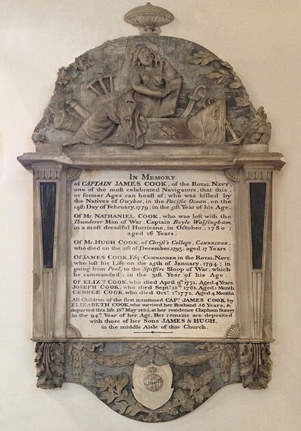
England
- Captain Cook Birthplace Museum, Stewart Park in Marton, Middlesbrough, North Yorkshire. This biographical museum opened on 28 October 1978, the 250th anniversary of Cook's birth, in the same spot. It champions and surveys his life, times and subsequent journeys. 2020-05-15
- Captain Cook Memorial Museum, Whitby, North Yorkshire, 54.4867°, -0.6118°. This house belonged to Captain John Walker, to whom James Cook was apprenticed in 1746. Having lodged there as an apprentice, Cook returned to visit in the winter of 1771–72 after his first voyage. 2020-05-15
- The Vache. Within the estate is a monument dedicated to the memory of Cook, who frequently visited the estate and named a South Sea island "Vache Island". 2020-05-15
Australia

- James Cook Collection, The Australian Museum, City East, Sydney, -33.8743°, 151.2134°. "Captain Cook" is a most esteemed household name in Australia; most coastal toponyms in Queensland and New South Wales given by him in his first voyage are used with pride to this day. Hundreds of artifacts collected on his three voyages throughout the Pacific Ocean, along with documents and memorabilia related to these voyages, are displayed here. Many of the ethnographic artifacts were collected at a time of first contact between Pacific peoples and Europeans. 2020-05-13
- Captain Cook's Landing Place, Captain Cook Drive, Kurnell (Sydney/Cronulla), -34.0315°, 151.172°. Sunrise to Sunset. You can stand on the rock where Captain Cook first stepped ashore, starting the process of European settlement. The landing place is also now next to a large oil refinery. There is a monument walk here, and an interpretive visitors centre. The area is never crowded with visitors, and many Sydneysiders have never visited. There are usually plenty of available and well maintained electric barbecues and picnic tables by the water. Buses can be a couple of hours apart so check the times. Sutherland Shire used to be named the birthplace of modern Australia, referring to European settlement. Now the aspects of the Aboriginal and European settlement interaction are emphasised, and interpreted in the visitors centre in the park. There is a National Park Admission fee ($11/24hr) to drive into the Park. If you only want to visit the monuments and see the landing place you can easily park just by the beach outside the park and not incur any fee to walk along the monument track from the other end. Foot or bicycle access is always free
- Point Danger Light (Captain Cook Memorial Light), 300 Boundary St, Tweed Heads NSW 2485, Gold Coast (the coastal boundary between Queensland and New South Wales). Sailing north from Botany Bay, on 16 May 1770 (log date) Endeavour encountered reefs formed by a lava flow from Mount Warning. To avoid them, Cook steered course to the east, and underlined "Mount Warning" and "Point Danger" in his log. Point Danger was later made official as the boundary mark between the colonies. The actual spot is today a controversy worth digressing with the locals (Cook Island, off Fingal Head, seems more likely what Cook meant); this is the official one, with his active lighthouse that lays claim to be the first in the world to experiment with laser as a light source (the experiment failed, and the light source was replaced in 1975 by a regular electric lamp), a Captain Cook memorial, the Centaur Memorial and Walk of Remembrance, the Marine Rescue NSW Point Danger station, and the southern end of the Gold Coast Oceanway. 2020-05-15
- Town of 1770 (Seventeen Seventy), Central Queensland. Built on the site of the second landing of Endeavour in Australia in May 1770 (and their first landing in what is nowadays the state of Queensland). The community of Seventeen Seventy hold the re-enactment of this historic landing each year as part of the 1770 Festival, held in May. There are also four National Parks in the vicinity. 2020-05-15
- Cooktown, Far North Queensland. On 17 June 1770, Endeavour was beached on the banks of the now-named Endeavour River, after she ran aground on the Great Barrier Reef. Undertaking repairs at the mouth of the river, she spent 48 days here. Both the town and the -high Mount Cook, which rises up behind the town, are named after James Cook. Today it is billed as the gateway to the Queensland wilderness, with mountains, Outback terrain and top scuba diving around. There is also a James Cook Museum, about Cook's voyages, Aboriginal and natural history, the gold rush and the legacy of the Chinese miners, housed in a former convent school, built in 1888 and run by Irish nuns. 2020-05-15
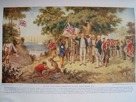
- Possession Island (Bedanug, Bedhan Lag), Far North Queensland. Here Captain Cook claimed possession of the entire east coast he had explored for Britain, on 22 August 1770. In his journal, he wrote: "I now once more hoisted English Coulers and in the Name of His Majesty King George the Third took possession of the whole Eastern Coast...by the name New South Wales, together with all the Bays, Harbours Rivers and Islands situate upon the said coast". Today, it's the centre of Possession Island National Park, an area of , established as a Protected Area in 1977, and managed by the Queensland Parks and Wildlife Service. 2020-05-18
Alaska
- Resolution Park, 320 L St, Anchorage, 61.220278°, -149.901389°. Small park featuring a bronze statue of Captain Cook standing on a wooden deck gazing out on Cook Inlet, which he explored in 1778 aboard HMS Resolution. The park was dedicated in 1978 and named for his ship. The park's interpretive display, powerful mounted telescope, and commanding vantage point make this a rewarding stop. 2020-10-23
Hawaii
- Monument to Cook's Death, Kealakekua Bay in Big Island, 19.481306°, -155.933444°. The attempted kidnapping of Kalaniʻōpuʻu, the ruling chief of the island of Hawaii, to hold him hostage for a stolen lifeboat was the fatal error of Cook's final voyage, and ultimately led to his death. A large white stone monument was commissioned by a local princess on the north shore of the bay in 1874, enclosed by a chain supported by four cannon from the ship HMS Fantome with their breaches embedded in the rock in 1876, and was deeded to the United Kingdom in 1877. It marks the approximate location of Cook's death. The Cook monument is unreachable by road; this remote location is accessible only by water or an hour-long hike along a moderately steep trail. Many visitors have rented kayaks in the town of Captain Cook and paddled across the bay, about 1.5 miles (2.4 km) from its southern end. State conservation regulations prohibit kayaks, stand-up paddleboards, surfboards, and bodyboards from entering the bay unless part of a tour with a licensed local operator. 2020-05-15